San Ignacio elevation
San Ignacio (Davao, Province of Davao Oriental), Philippines elevation is 22 meters and San Ignacio elevation in feet is 72 ft above sea level [src 1]. San Ignacio is a populated place (feature code) with elevation that is 66 meters (217 ft) smaller than average city elevation in Philippines.
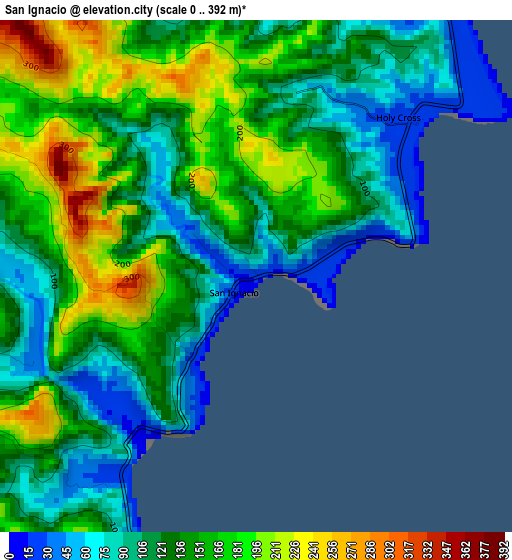
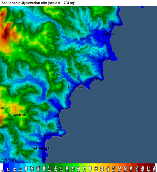
Below is the Elevation map of San Ignacio, which displays elevation range with different colors. Scale of the first map is from 0 to 392 m (0 to 1286 ft) with average elevation of 135.9 meters (=446 ft) [note 1]
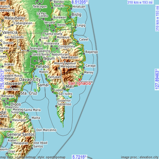
These maps also provides idea of topography and contour of this city, they are displayed at different zoom levels. More info about maps, scale and edge coordinates you can find below images.
| \ | Map #1 | Map #2 | Topo.Map |
| Scale [m] | 0..392 m | 0..704 m | × |
| Scale [ft] | 0..1286 ft | 0..2310 ft | × |
| Average | 135.9 m = 446 ft | 187.6 m = 615 ft | × |
| Width | 9.7 km = 6 mi | 19.39 km = 12 mi | 310.3 km = 192.8 mi |
| Height | 9.7 km = 6 mi | 19.39 km = 12 mi | 310.3 km = 192.8 mi |
| ↑Max Latitude | 7.162504° | 7.206105° | 8.51205° |
| Latitude at center | 7.1189° | 7.1189° | 7.1189° |
| ↓Min Latitude | 7.075291° | 7.031679° | 5.7215° |
| ← Min Longitude | 126.444435° | 126.400489° | 125.08213° |
| Longitude center | 126.48838° | 126.48838° | 126.48838° |
| →Max Longitude | 126.532325° | 126.576271° | 127.89463° |
Nearby cities:
Cities around San Ignacio sort by population:
• Mati elevation 21 m
35.1 km,  238°
238°
• Manay 15 m
12.1 km,  27°
27°
• Bobon 18 m
33 km,  212°
212°
• Caraga 29 m
25 km,  20°
20°
• San Pedro 30 m
25 km,  7°
7°
• Tarragona 21 m
9 km, 210°
• Mayo 16 m
21.6 km,  233°
233°
• Santiago 50 m
21.1 km, 26°
• Lukatan 95 m
14.2 km, 211°
• Jovellar 24 m
7.1 km, 210°
• Limot 221 m
25.3 km,  249°
249°
• San Luis 13 m
36.5 km, 10°
Multilingual:
 En español:
San Ignacio elevación 22 m.
 En France:
San Ignacio élévation 22 m.
 Auf Deutsch:
San Ignacio höhe über dem Meeresspiegel ist 22 m.

Sources and notes:
- [note 1] Map square and city borders are not equal. Map elevation data is calculated only from area inside that square.
- [src 1] Elevation data from geonames database provided with same terms of usage.
- [src 2] The elevation map of San Ignacio is generated using elevation data from NASA's 3 arcsec (90m) resolution SRTM data.
- [src 3] Base (background) map © OpenStreetMap contributors tiles are generated by Geofabrik and OpenTopoMap.
Copyright & License:
This San Ignacio Elevation Map is licensed under CC BY-SA. You may reuse any part from this page, if you give a proper credit by linking to this URL:
 More info on terms of use page.