San Miguel elevation
San Miguel (Caraga, Province of Surigao del Sur), Philippines elevation is 43 meters and San Miguel elevation in feet is 141 ft above sea level [src 1]. San Miguel is a populated place (feature code) with elevation that is 45 meters (148 ft) smaller than average city elevation in Philippines.
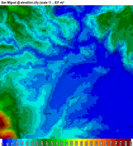
Below is the Elevation map of San Miguel, which displays elevation range with different colors. Scale of the first map is from 11 to 837 m (36 to 2746 ft) with average elevation of 131.4 meters (=431 ft) [note 1]
These maps also provides idea of topography and contour of this city, they are displayed at different zoom levels. More info about maps, scale and edge coordinates you can find below images.
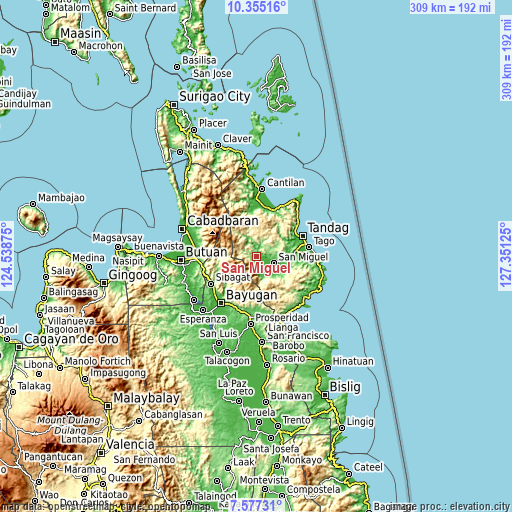
| \ | Map #1 | Topo.Map |
| Scale [m] | 11..837 m | × |
| Scale [ft] | 36..2746 ft | × |
| Average | 131.4 m = 431 ft | × |
| Width | 9.65 km = 6 mi | 308.9 km = 191.9 mi |
| Height | 9.65 km = 6 mi | 308.9 km = 191.9 mi |
| ↑Max Latitude | 9.012295° | 10.35516° |
| Latitude at center | 8.96889° | 8.96889° |
| ↓Min Latitude | 8.925479° | 7.57731° |
| ← Min Longitude | 125.901055° | 124.53875° |
| Longitude center | 125.945° | 125.945° |
| →Max Longitude | 125.988945° | 127.35125° |
Nearby cities:
Cities around San Miguel sort by population:
• Bayugan elevation 65 m
30.7 km,  219°
219°
• Tandag 8 m
30.4 km,  66°
66°
• Taligaman 199 m
32.6 km,  257°
257°
• Tago 9 m
32 km,  79°
79°
• Sibagat 46 m
31.7 km,  239°
239°
• Anticala 70 m
33.2 km,  276°
276°
• Madrid 19 m
32.7 km,  3°
3°
• Carmen 13 m
29.7 km,  15°
15°
• Buenavista 11 m
28.7 km,  55°
55°
• Mabahin 20 m
34.6 km,  45°
45°
• Gamut 8 m
25 km, 80°
• Lanuza 9 m
32.3 km, 23°
Multilingual:
 En español:
San Miguel elevación 43 m.
 En France:
San Miguel élévation 43 m.
 Auf Deutsch:
San Miguel höhe über dem Meeresspiegel ist 43 m.

Sources and notes:
- [note 1] Map square and city borders are not equal. Map elevation data is calculated only from area inside that square.
- [src 1] Elevation data from geonames database provided with same terms of usage.
- [src 2] The elevation map of San Miguel is generated using elevation data from NASA's 3 arcsec (90m) resolution SRTM data.
- [src 3] Base (background) map © OpenStreetMap contributors tiles are generated by Geofabrik and OpenTopoMap.
Copyright & License:
This San Miguel Elevation Map is licensed under CC BY-SA. You may reuse any part from this page, if you give a proper credit by linking to this URL:
 More info on terms of use page.