Santa Clara elevation
Santa Clara (Autonomous Region in Muslim Mindanao, Province of Basilan), Philippines elevation is 161 meters and Santa Clara elevation in feet is 528 ft above sea level [src 1]. Santa Clara is a populated place (feature code) with elevation that is 73 meters (240 ft) bigger than average city elevation in Philippines.
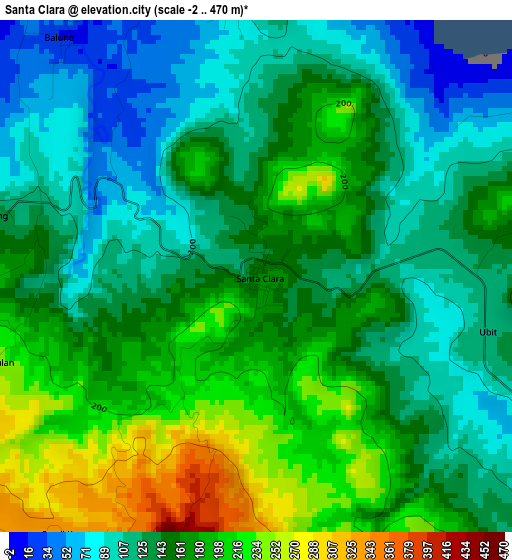
Below is the Elevation map of Santa Clara, which displays elevation range with different colors. Scale of the first map is from -2 to 470 m (-7 to 1542 ft) with average elevation of 153.1 meters (=502 ft) [note 1]
These maps also provides idea of topography and contour of this city, they are displayed at different zoom levels. More info about maps, scale and edge coordinates you can find below images.
| \ | Map #1 | Map #2 | Topo.Map |
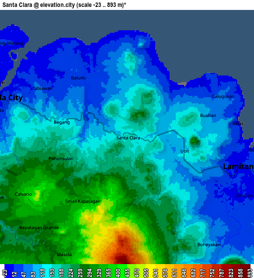
| Scale [m] | -2..470 m | -23..893 m | × |
| Scale [ft] | -7..1542 ft | -75..2930 ft | × |
| Average | 153.1 m = 502 ft | 172.3 m = 565 ft | × |
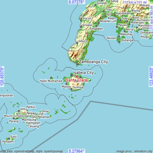
| Width | 9.71 km = 6 mi | 19.41 km = 12.1 mi | 310.6 km = 193 mi |
| Height | 9.71 km = 6 mi | 19.41 km = 12.1 mi | 310.6 km = 193 mi |
| ↑Max Latitude | 6.721845° | 6.765486° | 8.07278° |
| Latitude at center | 6.6782° | 6.6782° | 6.6782° |
| ↓Min Latitude | 6.634551° | 6.590898° | 5.27964° |
| ← Min Longitude | 122.016055° | 121.972109° | 120.65375° |
| Longitude center | 122.06° | 122.06° | 122.06° |
| →Max Longitude | 122.103945° | 122.147891° | 123.46625° |
Nearby cities:
Cities around Santa Clara sort by population:
• Zamboanga elevation 9 m
25.9 km,  3°
3°
• City of Isabela 10 m
10.2 km,  286°
286°
• Maluso 5 m
25.3 km,  233°
233°
• Tuburan 3 m
23.9 km,  99°
99°
• Lamitan City 42 m
8.3 km,  112°
112°
• Semut 8 m
17.6 km, 95°
• Tipo-Tipo 238 m
17 km,  129°
129°
• Tairan Camp 36 m
24.7 km,  260°
260°
• Colonia 19 m
11.4 km, 109°
• Begang 105 m
5 km, 286°
• Tablas 80 m
13.8 km, 113°
• Balas 12 m
8.7 km,  83°
83°
Multilingual:
 En español:
Santa Clara elevación 161 m.
 En France:
Santa Clara élévation 161 m.
 Auf Deutsch:
Santa Clara höhe über dem Meeresspiegel ist 161 m.

Sources and notes:
- [note 1] Map square and city borders are not equal. Map elevation data is calculated only from area inside that square.
- [src 1] Elevation data from geonames database provided with same terms of usage.
- [src 2] The elevation map of Santa Clara is generated using elevation data from NASA's 3 arcsec (90m) resolution SRTM data.
- [src 3] Base (background) map © OpenStreetMap contributors tiles are generated by Geofabrik and OpenTopoMap.
Copyright & License:
This Santa Clara Elevation Map is licensed under CC BY-SA. You may reuse any part from this page, if you give a proper credit by linking to this URL:
 More info on terms of use page.