Santo Niño elevation
Santo Niño (Cagayan Valley, Province of Cagayan), Philippines elevation is 22 meters and Santo Niño elevation in feet is 72 ft above sea level [src 1]. Santo Niño is a seat of a third-order administrative division (feature code) with elevation that is 66 meters (217 ft) smaller than average city elevation in Philippines.
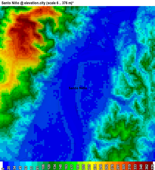
Below is the Elevation map of Santo Niño, which displays elevation range with different colors. Scale of the first map is from 6 to 376 m (20 to 1234 ft) with average elevation of 85.3 meters (=280 ft) [note 1]
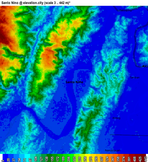
These maps also provides idea of topography and contour of this city, they are displayed at different zoom levels. More info about maps, scale and edge coordinates you can find below images.
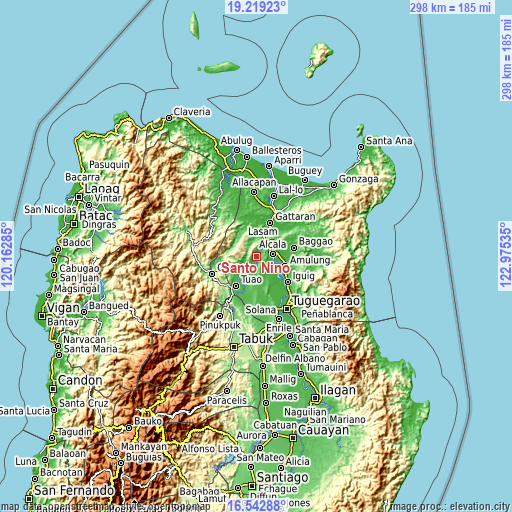
| \ | Map #1 | Map #2 | Topo.Map |
| Scale [m] | 6..376 m | 3..442 m | × |
| Scale [ft] | 20..1234 ft | 10..1450 ft | × |
| Average | 85.3 m = 280 ft | 83.7 m = 275 ft | × |
| Width | 9.3 km = 5.8 mi | 18.6 km = 11.6 mi | 297.6 km = 184.9 mi |
| Height | 9.3 km = 5.8 mi | 18.6 km = 11.6 mi | 297.6 km = 184.9 mi |
| ↑Max Latitude | 17.927916° | 17.969723° | 19.21923° |
| Latitude at center | 17.8861° | 17.8861° | 17.8861° |
| ↓Min Latitude | 17.844274° | 17.802438° | 16.54288° |
| ← Min Longitude | 121.525155° | 121.481209° | 120.16285° |
| Longitude center | 121.5691° | 121.5691° | 121.5691° |
| →Max Longitude | 121.613045° | 121.656991° | 122.97535° |
Nearby cities:
Cities around Santo Niño sort by population:
• Lasam elevation 15 m
20.2 km,  9°
9°
• Piat 56 m
14.4 km,  222°
222°
• Alcala 31 m
9.4 km,  79°
79°
• Afusing Centro 22 m
7.2 km,  121°
121°
• Maguilling 37 m
15 km,  210°
210°
• Calantac 21 m
16.5 km, 81°
• Dalaoig 41 m
16.9 km,  65°
65°
• Accusilian 38 m
19.1 km, 216°
• Amulung 25 m
17.3 km,  108°
108°
• Tupang 24 m
7.9 km, 74°
• Estefania 19 m
18.9 km, 120°
• Alannay 16 m
19.5 km, 5°
Multilingual:
 En español:
Santo Niño elevación 22 m.
 En France:
Santo Niño élévation 22 m.
 Auf Deutsch:
Santo Niño höhe über dem Meeresspiegel ist 22 m.

Sources and notes:
- [note 1] Map square and city borders are not equal. Map elevation data is calculated only from area inside that square.
- [src 1] Elevation data from geonames database provided with same terms of usage.
- [src 2] The elevation map of Santo Niño is generated using elevation data from NASA's 3 arcsec (90m) resolution SRTM data.
- [src 3] Base (background) map © OpenStreetMap contributors tiles are generated by Geofabrik and OpenTopoMap.
Copyright & License:
This Santo Niño Elevation Map is licensed under CC BY-SA. You may reuse any part from this page, if you give a proper credit by linking to this URL:
 More info on terms of use page.