San Vicente elevation
San Vicente (Bicol, Province of Camarines Sur), Philippines elevation is 25 meters and San Vicente elevation in feet is 82 ft above sea level [src 1]. San Vicente is a populated place (feature code) with elevation that is 63 meters (207 ft) smaller than average city elevation in Philippines.
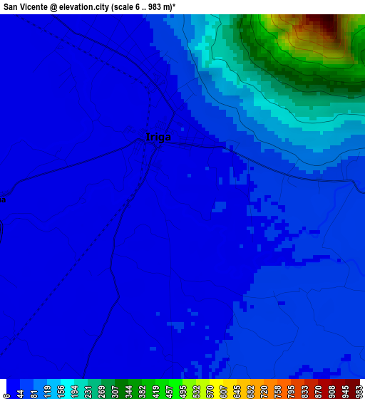
Below is the Elevation map of San Vicente, which displays elevation range with different colors. Scale of the first map is from 6 to 983 m (20 to 3225 ft) with average elevation of 76.6 meters (=251 ft) [note 1]
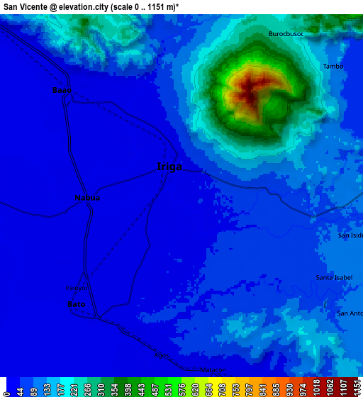
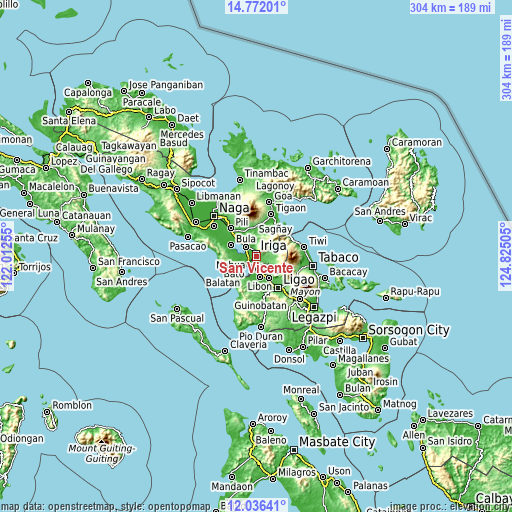
These maps also provides idea of topography and contour of this city, they are displayed at different zoom levels. More info about maps, scale and edge coordinates you can find below images.
| \ | Map #1 | Map #2 | Topo.Map |
| Scale [m] | 6..983 m | 0..1151 m | × |
| Scale [ft] | 20..3225 ft | 0..3776 ft | × |
| Average | 76.6 m = 251 ft | 96.7 m = 317 ft | × |
| Width | 9.51 km = 5.9 mi | 19.01 km = 11.8 mi | 304.2 km = 189 mi |
| Height | 9.51 km = 5.9 mi | 19.01 km = 11.8 mi | 304.2 km = 189 mi |
| ↑Max Latitude | 13.450844° | 13.49358° | 14.77201° |
| Latitude at center | 13.4081° | 13.4081° | 13.4081° |
| ↓Min Latitude | 13.365349° | 13.32259° | 12.03641° |
| ← Min Longitude | 123.374855° | 123.330909° | 122.01255° |
| Longitude center | 123.4188° | 123.4188° | 123.4188° |
| →Max Longitude | 123.462745° | 123.506691° | 124.82505° |
Nearby cities:
Cities around San Vicente sort by population:
• Iriga City elevation 30 m
2.8 km,  343°
343°
• Nabua 13 m
5 km,  269°
269°
• Santa Justina 70 m
6 km,  102°
102°
• Santo Domingo 126 m
3.5 km,  67°
67°
• San Antonio 42 m
4.1 km,  177°
177°
• Lourdes 16 m
5.3 km,  247°
247°
• San Vicente 16 m
7 km,  314°
314°
• San Miguel 19 m
1.7 km,  318°
318°
• Agos 30 m
7.5 km,  197°
197°
• Masoli 31 m
6.3 km,  210°
210°
• Salvacion 30 m
7.7 km, 323°
• Bagumbayan 58 m
7.1 km,  333°
333°
Multilingual:
 En español:
San Vicente elevación 25 m.
 En France:
San Vicente élévation 25 m.
 Auf Deutsch:
San Vicente höhe über dem Meeresspiegel ist 25 m.

Sources and notes:
- [note 1] Map square and city borders are not equal. Map elevation data is calculated only from area inside that square.
- [src 1] Elevation data from geonames database provided with same terms of usage.
- [src 2] The elevation map of San Vicente is generated using elevation data from NASA's 3 arcsec (90m) resolution SRTM data.
- [src 3] Base (background) map © OpenStreetMap contributors tiles are generated by Geofabrik and OpenTopoMap.
Copyright & License:
This San Vicente Elevation Map is licensed under CC BY-SA. You may reuse any part from this page, if you give a proper credit by linking to this URL:
 More info on terms of use page.