Subusub elevation
Subusub (Ilocos, Province of La Union), Philippines elevation is 153 meters and Subusub elevation in feet is 502 ft above sea level [src 1]. Subusub is a populated place (feature code) with elevation that is 65 meters (213 ft) bigger than average city elevation in Philippines.
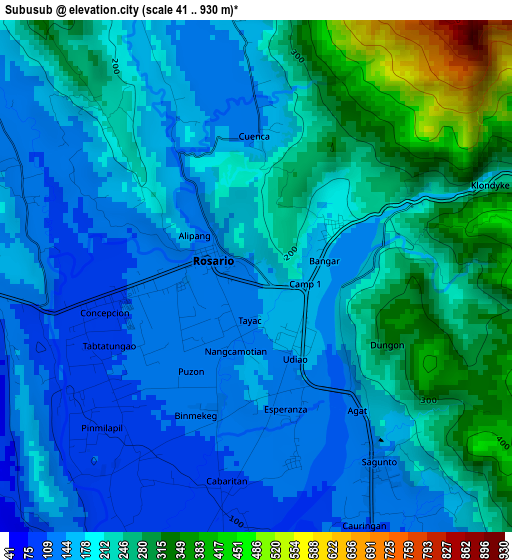
Below is the Elevation map of Subusub, which displays elevation range with different colors. Scale of the first map is from 41 to 930 m (135 to 3051 ft) with average elevation of 206.8 meters (=678 ft) [note 1]
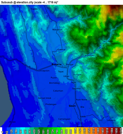
These maps also provides idea of topography and contour of this city, they are displayed at different zoom levels. More info about maps, scale and edge coordinates you can find below images.
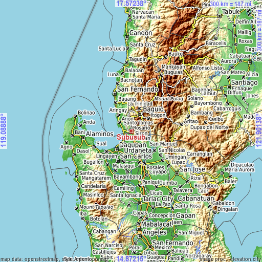
| \ | Map #1 | Map #2 | Topo.Map |
| Scale [m] | 41..930 m | -4..1716 m | × |
| Scale [ft] | 135..3051 ft | -13..5630 ft | × |
| Average | 206.8 m = 678 ft | 273.3 m = 897 ft | × |
| Width | 9.38 km = 5.8 mi | 18.77 km = 11.7 mi | 300.2 km = 186.5 mi |
| Height | 9.38 km = 5.8 mi | 18.77 km = 11.7 mi | 300.3 km = 186.6 mi |
| ↑Max Latitude | 16.26908° | 16.311261° | 17.57238° |
| Latitude at center | 16.22689° | 16.22689° | 16.22689° |
| ↓Min Latitude | 16.184691° | 16.142483° | 14.87215° |
| ← Min Longitude | 120.451185° | 120.407239° | 119.08888° |
| Longitude center | 120.49513° | 120.49513° | 120.49513° |
| →Max Longitude | 120.539075° | 120.583021° | 121.90138° |
Nearby cities:
Cities around Subusub sort by population:
• Sison elevation 93 m
6.3 km,  159°
159°
• Paldit 95 m
7.8 km,  148°
148°
• Inabaan Sur 180 m
4.4 km,  335°
335°
• Tabaan 394 m
8.4 km,  15°
15°
• Caronoan West 151 m
6.6 km,  307°
307°
• Bataquil 68 m
8.7 km, 156°
• Bobonan 56 m
10.8 km, 161°
• Nama 67 m
10.8 km, 151°
• Pugo 65 m
11 km, 344°
• Damortis 11 m
9.7 km,  279°
279°
• Sagunto 149 m
3.6 km,  144°
144°
• Rosario 126 m
1 km,  292°
292°
Multilingual:
 En español:
Subusub elevación 153 m.
 En France:
Subusub élévation 153 m.


Sources and notes:
- [note 1] Map square and city borders are not equal. Map elevation data is calculated only from area inside that square.
- [src 1] Elevation data from geonames database provided with same terms of usage.
- [src 2] The elevation map of Subusub is generated using elevation data from NASA's 3 arcsec (90m) resolution SRTM data.
- [src 3] Base (background) map © OpenStreetMap contributors tiles are generated by Geofabrik and OpenTopoMap.
Copyright & License:
This Subusub Elevation Map is licensed under CC BY-SA. You may reuse any part from this page, if you give a proper credit by linking to this URL:
 More info on terms of use page.