Sulop elevation
Sulop (Davao, Province of Davao del Sur), Philippines elevation is 16 meters and Sulop elevation in feet is 52 ft above sea level [src 1]. Sulop is a seat of a third-order administrative division (feature code) with elevation that is 72 meters (236 ft) smaller than average city elevation in Philippines.
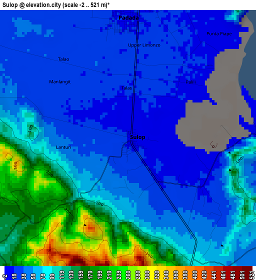
Below is the Elevation map of Sulop, which displays elevation range with different colors. Scale of the first map is from -2 to 521 m (-7 to 1709 ft) with average elevation of 79.7 meters (=261 ft) [note 1]
These maps also provides idea of topography and contour of this city, they are displayed at different zoom levels. More info about maps, scale and edge coordinates you can find below images.
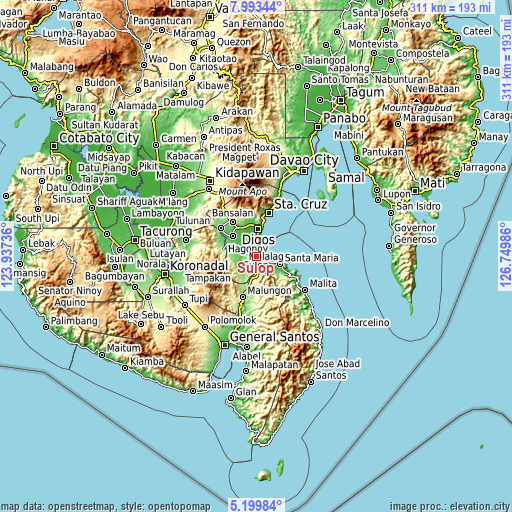
| \ | Map #1 | Map #2 | Topo.Map |
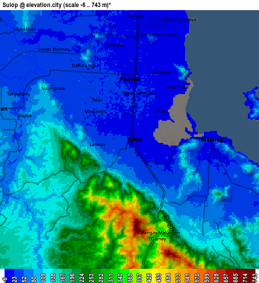
| Scale [m] | -2..521 m | -6..743 m | × |
| Scale [ft] | -7..1709 ft | -20..2438 ft | × |
| Average | 79.7 m = 261 ft | 113.5 m = 372 ft | × |
| Width | 9.71 km = 6 mi | 19.42 km = 12.1 mi | 310.6 km = 193 mi |
| Height | 9.71 km = 6 mi | 19.42 km = 12.1 mi | 310.6 km = 193 mi |
| ↑Max Latitude | 6.642262° | 6.685911° | 7.99344° |
| Latitude at center | 6.59861° | 6.59861° | 6.59861° |
| ↓Min Latitude | 6.554954° | 6.511294° | 5.19984° |
| ← Min Longitude | 125.299665° | 125.255719° | 123.93736° |
| Longitude center | 125.34361° | 125.34361° | 125.34361° |
| →Max Longitude | 125.387555° | 125.431501° | 126.74986° |
Nearby cities:
Cities around Sulop sort by population:
• Guihing Proper elevation 13 m
9.6 km,  5°
5°
• Padada 17 m
4.7 km,  1°
1°
• Hagonoy 16 m
9.6 km,  348°
348°
• Matanao 42 m
13.3 km,  312°
312°
• Malalag 13 m
6.1 km,  92°
92°
• Sinayawan 13 m
13.2 km,  343°
343°
• Bulacan 30 m
9.2 km,  112°
112°
• Kiblawan 94 m
11.9 km,  278°
278°
• New Baclayon 12 m
3.3 km,  119°
119°
• Ignit 16 m
12.7 km,  333°
333°
• Malinao 34 m
9.2 km,  316°
316°
• Tanlad 11 m
11.2 km, 87°
Multilingual:
 En español:
Sulop elevación 16 m.
 En France:
Sulop élévation 16 m.


Sources and notes:
- [note 1] Map square and city borders are not equal. Map elevation data is calculated only from area inside that square.
- [src 1] Elevation data from geonames database provided with same terms of usage.
- [src 2] The elevation map of Sulop is generated using elevation data from NASA's 3 arcsec (90m) resolution SRTM data.
- [src 3] Base (background) map © OpenStreetMap contributors tiles are generated by Geofabrik and OpenTopoMap.
Copyright & License:
This Sulop Elevation Map is licensed under CC BY-SA. You may reuse any part from this page, if you give a proper credit by linking to this URL:
 More info on terms of use page.