Tabuating elevation
Tabuating (Central Luzon, Province of Nueva Ecija), Philippines elevation is 28 meters and Tabuating elevation in feet is 92 ft above sea level [src 1]. Tabuating is a populated place (feature code) with elevation that is 60 meters (197 ft) smaller than average city elevation in Philippines.
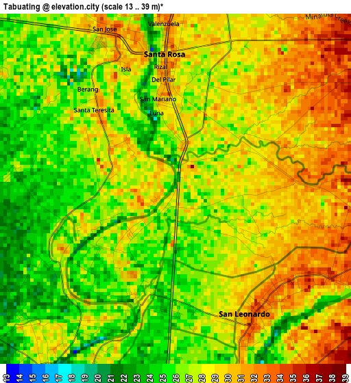
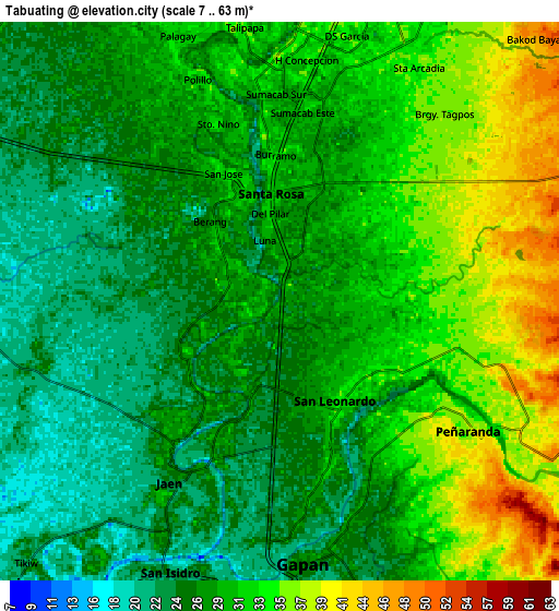
Below is the Elevation map of Tabuating, which displays elevation range with different colors. Scale of the first map is from 13 to 39 m (43 to 128 ft) with average elevation of 27.5 meters (=90 ft) [note 1]
These maps also provides idea of topography and contour of this city, they are displayed at different zoom levels. More info about maps, scale and edge coordinates you can find below images.
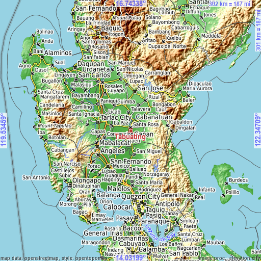
| \ | Map #1 | Map #2 | Topo.Map |
| Scale [m] | 13..39 m | 7..63 m | × |
| Scale [ft] | 43..128 ft | 23..207 ft | × |
| Average | 27.5 m = 90 ft | 29.3 m = 96 ft | × |
| Width | 9.42 km = 5.9 mi | 18.84 km = 11.7 mi | 301.5 km = 187.3 mi |
| Height | 9.42 km = 5.9 mi | 18.84 km = 11.7 mi | 301.5 km = 187.3 mi |
| ↑Max Latitude | 15.434465° | 15.476821° | 16.74338° |
| Latitude at center | 15.3921° | 15.3921° | 15.3921° |
| ↓Min Latitude | 15.349727° | 15.307345° | 14.03199° |
| ← Min Longitude | 120.896895° | 120.852949° | 119.53459° |
| Longitude center | 120.94084° | 120.94084° | 120.94084° |
| →Max Longitude | 120.984785° | 121.028731° | 122.34709° |
Nearby cities:
Cities around Tabuating sort by population:
• Gapan elevation 24 m
9.5 km,  176°
176°
• Jaen 25 m
7.5 km,  197°
197°
• San Leonardo 32 m
4.1 km,  142°
142°
• Peñaranda 41 m
8.2 km,  123°
123°
• Santa Rosa 31 m
3.5 km,  354°
354°
• Nieves 27 m
7.1 km,  173°
173°
• Santo Rosario 27 m
7.2 km,  310°
310°
• San Anton 26 m
5.4 km, 204°
• Soledad 36 m
6.1 km,  48°
48°
• Putlod 27 m
8.2 km,  253°
253°
• Lambakin 24 m
8.9 km,  255°
255°
• Lawang Kupang 22 m
10.2 km,  241°
241°
Multilingual:
 En español:
Tabuating elevación 28 m.
 En France:
Tabuating élévation 28 m.
 Auf Deutsch:
Tabuating höhe über dem Meeresspiegel ist 28 m.

Sources and notes:
- [note 1] Map square and city borders are not equal. Map elevation data is calculated only from area inside that square.
- [src 1] Elevation data from geonames database provided with same terms of usage.
- [src 2] The elevation map of Tabuating is generated using elevation data from NASA's 3 arcsec (90m) resolution SRTM data.
- [src 3] Base (background) map © OpenStreetMap contributors tiles are generated by Geofabrik and OpenTopoMap.
Copyright & License:
This Tabuating Elevation Map is licensed under CC BY-SA. You may reuse any part from this page, if you give a proper credit by linking to this URL:
 More info on terms of use page.