Taclobo elevation
Taclobo (Mimaropa, Province of Romblon), Philippines elevation is 11 meters and Taclobo elevation in feet is 36 ft above sea level [src 1]. Taclobo is a populated place (feature code) with elevation that is 77 meters (253 ft) smaller than average city elevation in Philippines.
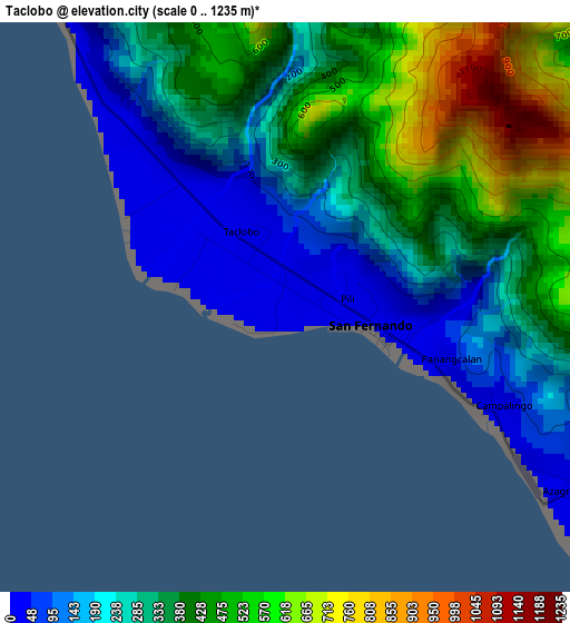
Below is the Elevation map of Taclobo, which displays elevation range with different colors. Scale of the first map is from 0 to 1235 m (0 to 4052 ft) with average elevation of 335.6 meters (=1101 ft) [note 1]
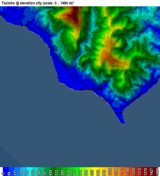
These maps also provides idea of topography and contour of this city, they are displayed at different zoom levels. More info about maps, scale and edge coordinates you can find below images.
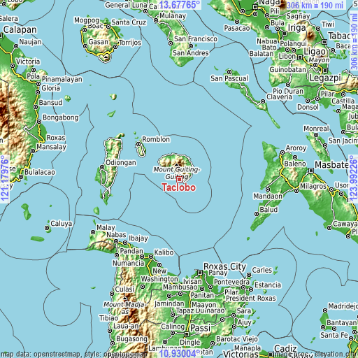
| \ | Map #1 | Map #2 | Topo.Map |
| Scale [m] | 0..1235 m | -3..1484 m | × |
| Scale [ft] | 0..4052 ft | -10..4869 ft | × |
| Average | 335.6 m = 1101 ft | 399 m = 1309 ft | × |
| Width | 9.55 km = 5.9 mi | 19.1 km = 11.9 mi | 305.5 km = 189.8 mi |
| Height | 9.55 km = 5.9 mi | 19.1 km = 11.9 mi | 305.5 km = 189.8 mi |
| ↑Max Latitude | 12.350372° | 12.393297° | 13.67765° |
| Latitude at center | 12.30744° | 12.30744° | 12.30744° |
| ↓Min Latitude | 12.264501° | 12.221555° | 10.93004° |
| ← Min Longitude | 122.542065° | 122.498119° | 121.17976° |
| Longitude center | 122.58601° | 122.58601° | 122.58601° |
| →Max Longitude | 122.629955° | 122.673901° | 123.99226° |
Nearby cities:
Cities around Taclobo sort by population:
• Romblon elevation 14 m
45.4 km,  311°
311°
• Concepcion 71 m
54.4 km,  280°
280°
• San Agustin 8 m
57.3 km,  300°
300°
• Tampayan 47 m
21.5 km,  344°
344°
• Cajimos 23 m
46.5 km, 313°
• Magdiwang 10 m
21.1 km, 338°
• España 9 m
12.7 km, 312°
• Alad 15 m
50.3 km, 313°
• Tugdan 9 m
54.4 km,  270°
270°
• Sogod 190 m
11.4 km,  47°
47°
• Cajidiocan 50 m
12.3 km,  57°
57°
• San Fernando 6 m
1.6 km,  105°
105°
Multilingual:
 En español:
Taclobo elevación 11 m.
 En France:
Taclobo élévation 11 m.


Sources and notes:
- [note 1] Map square and city borders are not equal. Map elevation data is calculated only from area inside that square.
- [src 1] Elevation data from geonames database provided with same terms of usage.
- [src 2] The elevation map of Taclobo is generated using elevation data from NASA's 3 arcsec (90m) resolution SRTM data.
- [src 3] Base (background) map © OpenStreetMap contributors tiles are generated by Geofabrik and OpenTopoMap.
Copyright & License:
This Taclobo Elevation Map is licensed under CC BY-SA. You may reuse any part from this page, if you give a proper credit by linking to this URL:
 More info on terms of use page.