Tartaro elevation
Tartaro (Central Luzon, Province of Bulacan), Philippines elevation is 36 meters and Tartaro elevation in feet is 118 ft above sea level [src 1]. Tartaro is a populated place (feature code) with elevation that is 52 meters (171 ft) smaller than average city elevation in Philippines.
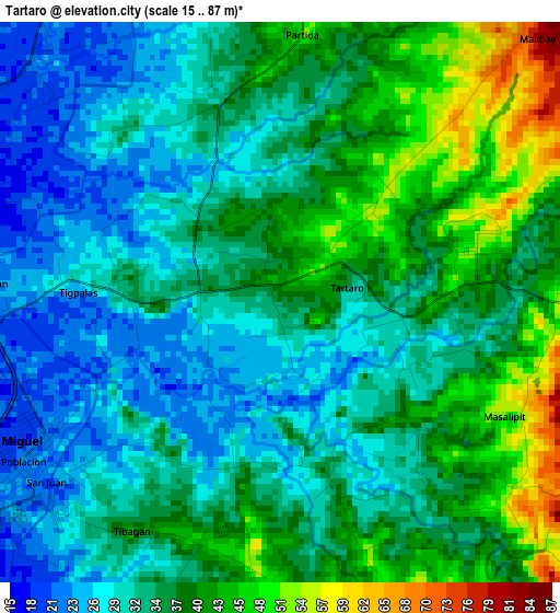
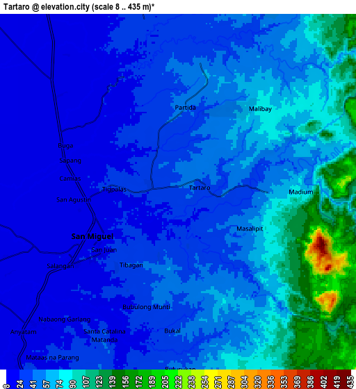
Below is the Elevation map of Tartaro, which displays elevation range with different colors. Scale of the first map is from 15 to 87 m (49 to 285 ft) with average elevation of 35.2 meters (=115 ft) [note 1]
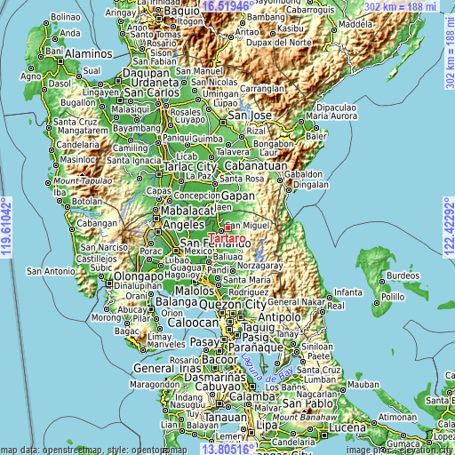
These maps also provides idea of topography and contour of this city, they are displayed at different zoom levels. More info about maps, scale and edge coordinates you can find below images.
| \ | Map #1 | Map #2 | Topo.Map |
| Scale [m] | 15..87 m | 8..435 m | × |
| Scale [ft] | 49..285 ft | 26..1427 ft | × |
| Average | 35.2 m = 115 ft | 52.2 m = 171 ft | × |
| Width | 9.43 km = 5.9 mi | 18.86 km = 11.7 mi | 301.8 km = 187.5 mi |
| Height | 9.43 km = 5.9 mi | 18.86 km = 11.7 mi | 301.8 km = 187.5 mi |
| ↑Max Latitude | 15.20908° | 15.251482° | 16.51946° |
| Latitude at center | 15.16667° | 15.16667° | 15.16667° |
| ↓Min Latitude | 15.124251° | 15.081824° | 13.80516° |
| ← Min Longitude | 120.972725° | 120.928779° | 119.61042° |
| Longitude center | 121.01667° | 121.01667° | 121.01667° |
| →Max Longitude | 121.060615° | 121.104561° | 122.42292° |
Nearby cities:
Cities around Tartaro sort by population:
• San Ildefonso elevation 22 m
12.5 km,  220°
220°
• San Miguel 24 m
5.2 km,  238°
238°
• Sibul 54 m
4.8 km,  86°
86°
• Camias 23 m
4.6 km,  270°
270°
• Salapungan 15 m
10.2 km,  249°
249°
• Batasan Bata 15 m
8.5 km, 253°
• Calumpang 50 m
1.2 km,  47°
47°
• Mapaniqui 13 m
12.1 km, 236°
• Pinambaran 24 m
5.7 km,  313°
313°
• Santa Lucia 31 m
4.9 km,  346°
346°
• Bulualto 21 m
9.1 km, 311°
• Masalipit 42 m
3 km,  133°
133°
Multilingual:
 En español:
Tartaro elevación 36 m.
 En France:
Tartaro élévation 36 m.


Sources and notes:
- [note 1] Map square and city borders are not equal. Map elevation data is calculated only from area inside that square.
- [src 1] Elevation data from geonames database provided with same terms of usage.
- [src 2] The elevation map of Tartaro is generated using elevation data from NASA's 3 arcsec (90m) resolution SRTM data.
- [src 3] Base (background) map © OpenStreetMap contributors tiles are generated by Geofabrik and OpenTopoMap.
Copyright & License:
This Tartaro Elevation Map is licensed under CC BY-SA. You may reuse any part from this page, if you give a proper credit by linking to this URL:
 More info on terms of use page.