Tibanbang elevation
Tibanbang (Davao, Province of Davao Oriental), Philippines elevation is 42 meters and Tibanbang elevation in feet is 138 ft above sea level [src 1]. Tibanbang is a populated place (feature code) with elevation that is 46 meters (151 ft) smaller than average city elevation in Philippines.
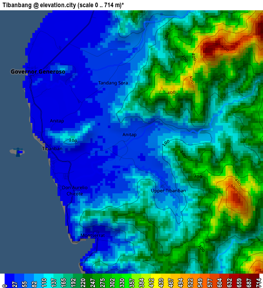
Below is the Elevation map of Tibanbang, which displays elevation range with different colors. Scale of the first map is from 0 to 714 m (0 to 2343 ft) with average elevation of 161.1 meters (=529 ft) [note 1]
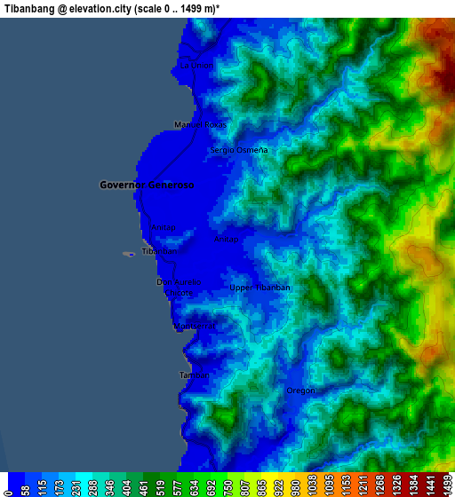
These maps also provides idea of topography and contour of this city, they are displayed at different zoom levels. More info about maps, scale and edge coordinates you can find below images.
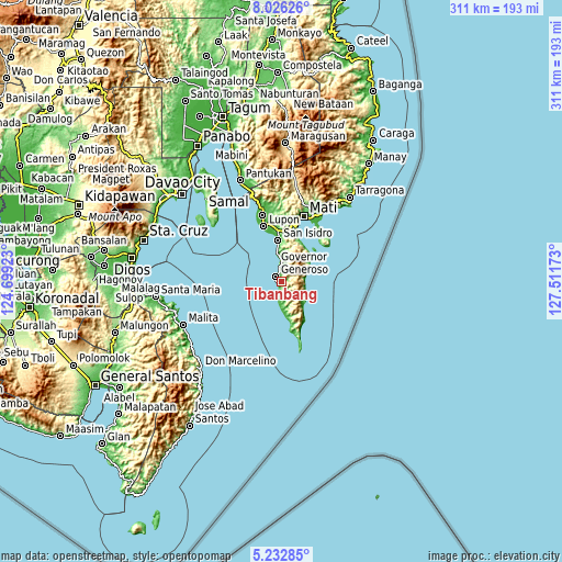
| \ | Map #1 | Map #2 | Topo.Map |
| Scale [m] | 0..714 m | 0..1499 m | × |
| Scale [ft] | 0..2343 ft | 0..4918 ft | × |
| Average | 161.1 m = 529 ft | 368.1 m = 1208 ft | × |
| Width | 9.71 km = 6 mi | 19.41 km = 12.1 mi | 310.6 km = 193 mi |
| Height | 9.71 km = 6 mi | 19.41 km = 12.1 mi | 310.6 km = 193 mi |
| ↑Max Latitude | 6.675179° | 6.718825° | 8.02626° |
| Latitude at center | 6.63153° | 6.63153° | 6.63153° |
| ↓Min Latitude | 6.587877° | 6.54422° | 5.23285° |
| ← Min Longitude | 126.061535° | 126.017589° | 124.69923° |
| Longitude center | 126.10548° | 126.10548° | 126.10548° |
| →Max Longitude | 126.149425° | 126.193371° | 127.51173° |
Nearby cities:
Cities around Tibanbang sort by population:
• Batobato elevation 21 m
21.7 km,  353°
353°
• Sigaboy 13 m
4.4 km,  304°
304°
• La Union 19 m
8.3 km, 346°
• Baon 18 m
18.3 km, 353°
• Nangan 25 m
17.8 km,  173°
173°
• Luzon 16 m
12.6 km,  185°
185°
• Tiblawan 6 m
17 km,  178°
178°
• Talisay 58 m
9.8 km,  356°
356°
• Manikling 21 m
28 km, 349°
• Magdug 17 m
9.4 km, 187°
• Bitaogan 18 m
15.5 km, 348°
• Surup 37 m
27.2 km, 170°
Multilingual:
 En español:
Tibanbang elevación 42 m.
 En France:
Tibanbang élévation 42 m.
 Auf Deutsch:
Tibanbang höhe über dem Meeresspiegel ist 42 m.

Sources and notes:
- [note 1] Map square and city borders are not equal. Map elevation data is calculated only from area inside that square.
- [src 1] Elevation data from geonames database provided with same terms of usage.
- [src 2] The elevation map of Tibanbang is generated using elevation data from NASA's 3 arcsec (90m) resolution SRTM data.
- [src 3] Base (background) map © OpenStreetMap contributors tiles are generated by Geofabrik and OpenTopoMap.
Copyright & License:
This Tibanbang Elevation Map is licensed under CC BY-SA. You may reuse any part from this page, if you give a proper credit by linking to this URL:
 More info on terms of use page.