Tuban elevation
Tuban (Davao, Province of Davao del Sur), Philippines elevation is 19 meters and Tuban elevation in feet is 62 ft above sea level [src 1]. Tuban is a populated place (feature code) with elevation that is 69 meters (226 ft) smaller than average city elevation in Philippines.
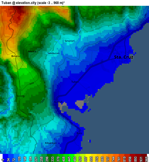
Below is the Elevation map of Tuban, which displays elevation range with different colors. Scale of the first map is from -3 to 968 m (-10 to 3176 ft) with average elevation of 233.8 meters (=767 ft) [note 1]
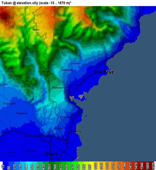
These maps also provides idea of topography and contour of this city, they are displayed at different zoom levels. More info about maps, scale and edge coordinates you can find below images.
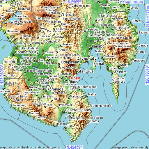
| \ | Map #1 | Map #2 | Topo.Map |
| Scale [m] | -3..968 m | -15..1670 m | × |
| Scale [ft] | -10..3176 ft | -49..5479 ft | × |
| Average | 233.8 m = 767 ft | 391 m = 1283 ft | × |
| Width | 9.7 km = 6 mi | 19.41 km = 12.1 mi | 310.5 km = 192.9 mi |
| Height | 9.7 km = 6 mi | 19.41 km = 12.1 mi | 310.5 km = 192.9 mi |
| ↑Max Latitude | 6.866412° | 6.91004° | 8.2169° |
| Latitude at center | 6.82278° | 6.82278° | 6.82278° |
| ↓Min Latitude | 6.779144° | 6.735504° | 5.42459° |
| ← Min Longitude | 125.342995° | 125.299049° | 123.98069° |
| Longitude center | 125.38694° | 125.38694° | 125.38694° |
| →Max Longitude | 125.430885° | 125.474831° | 126.79319° |
Nearby cities:
Cities around Tuban sort by population:
• Digos elevation 18 m
8.8 km,  201°
201°
• Guihing Proper 13 m
15.8 km,  193°
193°
• Astorga 45 m
12.1 km,  39°
39°
• Sibulan 63 m
14.9 km,  33°
33°
• Coronon 20 m
9.3 km,  47°
47°
• Sinayawan 13 m
15 km,  214°
214°
• Matti 47 m
10.4 km,  236°
236°
• Goma 80 m
8.1 km, 244°
• Managa 66 m
15.7 km, 236°
• Balutakay 10 m
12 km, 199°
• Takub 122 m
5.4 km, 46°
• Santa Cruz 12 m
3.3 km,  61°
61°
Multilingual:
 En español:
Tuban elevación 19 m.
 En France:
Tuban élévation 19 m.


Sources and notes:
- [note 1] Map square and city borders are not equal. Map elevation data is calculated only from area inside that square.
- [src 1] Elevation data from geonames database provided with same terms of usage.
- [src 2] The elevation map of Tuban is generated using elevation data from NASA's 3 arcsec (90m) resolution SRTM data.
- [src 3] Base (background) map © OpenStreetMap contributors tiles are generated by Geofabrik and OpenTopoMap.
Copyright & License:
This Tuban Elevation Map is licensed under CC BY-SA. You may reuse any part from this page, if you give a proper credit by linking to this URL:
 More info on terms of use page.