Tubay elevation
Tubay (Caraga, Province of Agusan del Norte), Philippines elevation is 12 meters and Tubay elevation in feet is 39 ft above sea level [src 1]. Tubay is a seat of a third-order administrative division (feature code) with elevation that is 76 meters (249 ft) smaller than average city elevation in Philippines.
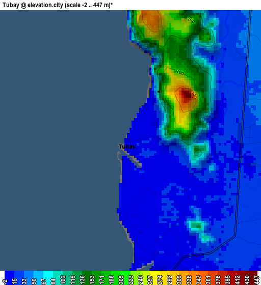
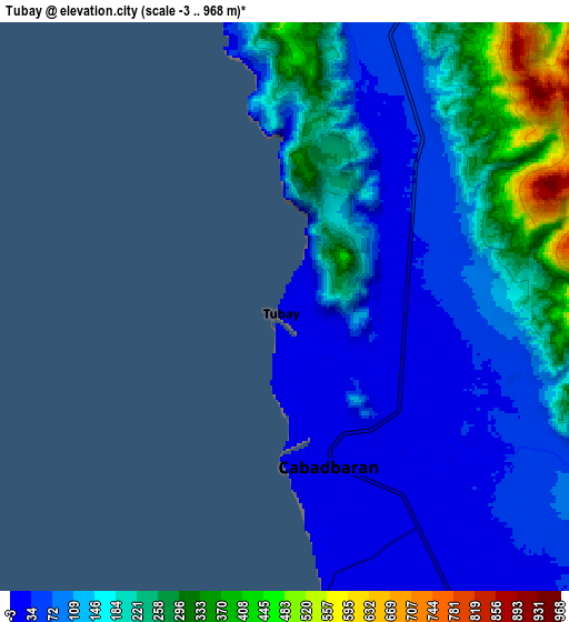
Below is the Elevation map of Tubay, which displays elevation range with different colors. Scale of the first map is from -2 to 447 m (-7 to 1467 ft) with average elevation of 58.2 meters (=191 ft) [note 1]
These maps also provides idea of topography and contour of this city, they are displayed at different zoom levels. More info about maps, scale and edge coordinates you can find below images.
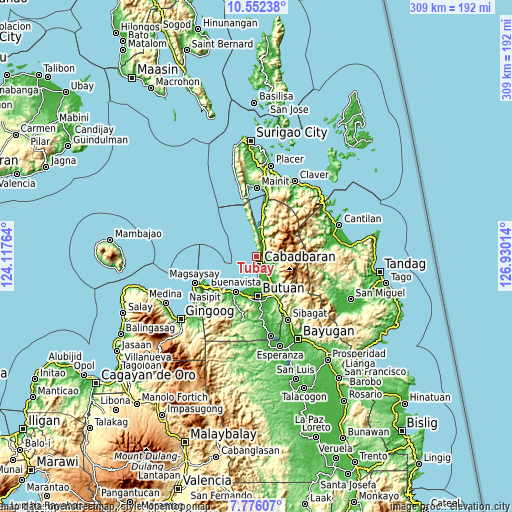
| \ | Map #1 | Map #2 | Topo.Map |
| Scale [m] | -2..447 m | -3..968 m | × |
| Scale [ft] | -7..1467 ft | -10..3176 ft | × |
| Average | 58.2 m = 191 ft | 141.5 m = 464 ft | × |
| Width | 9.65 km = 6 mi | 19.3 km = 12 mi | 308.7 km = 191.8 mi |
| Height | 9.65 km = 6 mi | 19.3 km = 12 mi | 308.7 km = 191.8 mi |
| ↑Max Latitude | 9.210321° | 9.253697° | 10.55238° |
| Latitude at center | 9.16694° | 9.16694° | 9.16694° |
| ↓Min Latitude | 9.123553° | 9.080161° | 7.77607° |
| ← Min Longitude | 125.479945° | 125.435999° | 124.11764° |
| Longitude center | 125.52389° | 125.52389° | 125.52389° |
| →Max Longitude | 125.567835° | 125.611781° | 126.93014° |
Nearby cities:
Cities around Tubay sort by population:
• Cabadbaran elevation 10 m
5.1 km,  165°
165°
• Magallanes 6 m
16.4 km,  182°
182°
• La Union 6 m
9.1 km, 171°
• Agay 14 m
14.4 km,  151°
151°
• Caloc-an 8 m
13.4 km, 176°
• Comagascas 23 m
5 km,  127°
127°
• Calamba 42 m
10.4 km, 132°
• Del Pilar 40 m
6.9 km,  104°
104°
• Sanghan 13 m
10.5 km, 149°
• Santa Ana 38 m
5.3 km,  57°
57°
• Jagupit 45 m
9.2 km,  24°
24°
• Balangbalang 43 m
16.4 km,  138°
138°
Multilingual:
 En español:
Tubay elevación 12 m.
 En France:
Tubay élévation 12 m.


Sources and notes:
- [note 1] Map square and city borders are not equal. Map elevation data is calculated only from area inside that square.
- [src 1] Elevation data from geonames database provided with same terms of usage.
- [src 2] The elevation map of Tubay is generated using elevation data from NASA's 3 arcsec (90m) resolution SRTM data.
- [src 3] Base (background) map © OpenStreetMap contributors tiles are generated by Geofabrik and OpenTopoMap.
Copyright & License:
This Tubay Elevation Map is licensed under CC BY-SA. You may reuse any part from this page, if you give a proper credit by linking to this URL:
 More info on terms of use page.