Tutay elevation
Tutay (Central Visayas, Province of Cebu), Philippines elevation is 14 meters and Tutay elevation in feet is 46 ft above sea level [src 1]. Tutay is a populated place (feature code) with elevation that is 74 meters (243 ft) smaller than average city elevation in Philippines.
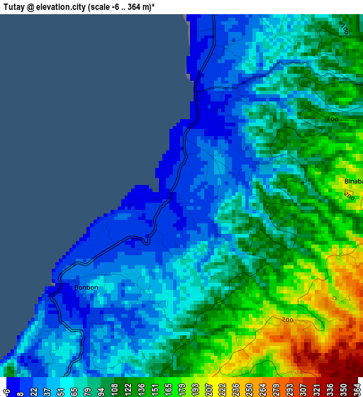
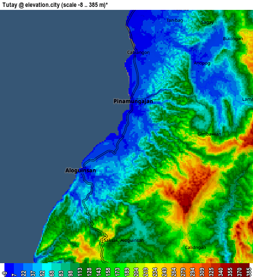
Below is the Elevation map of Tutay, which displays elevation range with different colors. Scale of the first map is from -6 to 364 m (-20 to 1194 ft) with average elevation of 91.9 meters (=302 ft) [note 1]
These maps also provides idea of topography and contour of this city, they are displayed at different zoom levels. More info about maps, scale and edge coordinates you can find below images.
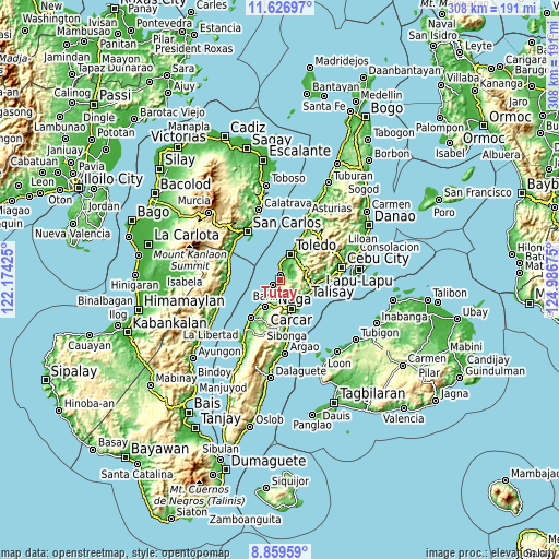
| \ | Map #1 | Map #2 | Topo.Map |
| Scale [m] | -6..364 m | -8..385 m | × |
| Scale [ft] | -20..1194 ft | -26..1263 ft | × |
| Average | 91.9 m = 302 ft | 117.3 m = 385 ft | × |
| Width | 9.62 km = 6 mi | 19.23 km = 11.9 mi | 307.7 km = 191.2 mi |
| Height | 9.62 km = 6 mi | 19.23 km = 11.9 mi | 307.7 km = 191.2 mi |
| ↑Max Latitude | 10.289542° | 10.332777° | 11.62697° |
| Latitude at center | 10.2463° | 10.2463° | 10.2463° |
| ↓Min Latitude | 10.203053° | 10.159799° | 8.85959° |
| ← Min Longitude | 123.536555° | 123.492609° | 122.17425° |
| Longitude center | 123.5805° | 123.5805° | 123.5805° |
| →Max Longitude | 123.624445° | 123.668391° | 124.98675° |
Nearby cities:
Cities around Tutay sort by population:
• Pinamungahan elevation 2 m
2.7 km,  7°
7°
• Guadalupe 224 m
14.7 km,  168°
168°
• Can-asujan 54 m
15.4 km,  146°
146°
• Bonbon 43 m
3.5 km,  226°
226°
• Tajao 3 m
7.6 km,  2°
2°
• Valencia 152 m
12.8 km,  164°
164°
• Uling 149 m
14.7 km,  74°
74°
• Aloguinsan 6 m
4.4 km, 232°
• Alpaco 288 m
11.2 km,  91°
91°
• Lut-od 92 m
5.5 km,  77°
77°
• Buenavista 117 m
8 km, 163°
• Mantalongon 167 m
13.4 km,  179°
179°
Multilingual:
 En español:
Tutay elevación 14 m.
 En France:
Tutay élévation 14 m.


Sources and notes:
- [note 1] Map square and city borders are not equal. Map elevation data is calculated only from area inside that square.
- [src 1] Elevation data from geonames database provided with same terms of usage.
- [src 2] The elevation map of Tutay is generated using elevation data from NASA's 3 arcsec (90m) resolution SRTM data.
- [src 3] Base (background) map © OpenStreetMap contributors tiles are generated by Geofabrik and OpenTopoMap.
Copyright & License:
This Tutay Elevation Map is licensed under CC BY-SA. You may reuse any part from this page, if you give a proper credit by linking to this URL:
 More info on terms of use page.