Unzad elevation
Unzad (Ilocos, Province of Pangasinan), Philippines elevation is 40 meters and Unzad elevation in feet is 131 ft above sea level [src 1]. Unzad is a populated place (feature code) with elevation that is 48 meters (157 ft) smaller than average city elevation in Philippines.
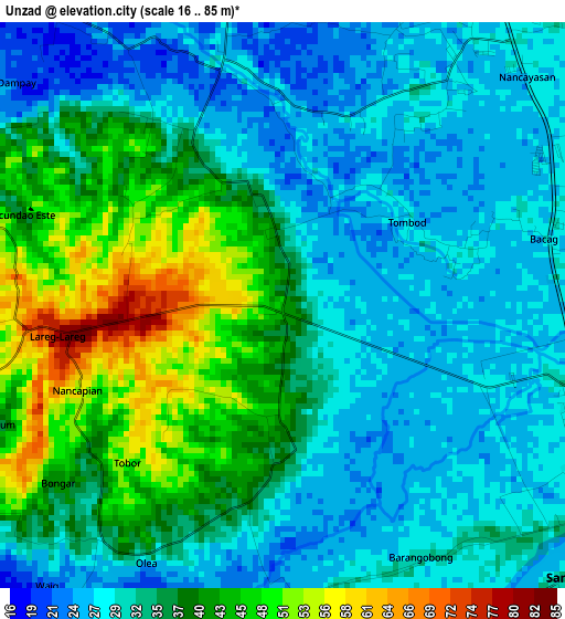
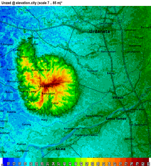
Below is the Elevation map of Unzad, which displays elevation range with different colors. Scale of the first map is from 16 to 85 m (52 to 279 ft) with average elevation of 34.4 meters (=113 ft) [note 1]
These maps also provides idea of topography and contour of this city, they are displayed at different zoom levels. More info about maps, scale and edge coordinates you can find below images.
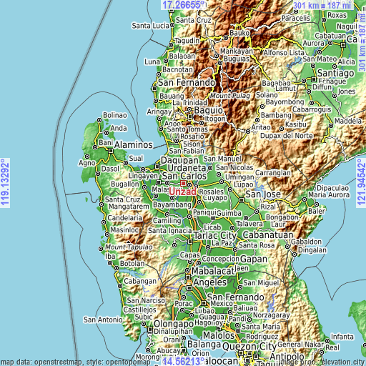
| \ | Map #1 | Map #2 | Topo.Map |
| Scale [m] | 16..85 m | 7..85 m | × |
| Scale [ft] | 52..279 ft | 23..279 ft | × |
| Average | 34.4 m = 113 ft | 27.8 m = 91 ft | × |
| Width | 9.4 km = 5.8 mi | 18.8 km = 11.7 mi | 300.7 km = 186.8 mi |
| Height | 9.4 km = 5.8 mi | 18.8 km = 11.7 mi | 300.7 km = 186.8 mi |
| ↑Max Latitude | 15.961146° | 16.003392° | 17.26655° |
| Latitude at center | 15.91889° | 15.91889° | 15.91889° |
| ↓Min Latitude | 15.876626° | 15.834352° | 14.56213° |
| ← Min Longitude | 120.495225° | 120.451279° | 119.13292° |
| Longitude center | 120.53917° | 120.53917° | 120.53917° |
| →Max Longitude | 120.583115° | 120.627061° | 121.94542° |
Nearby cities:
Cities around Unzad sort by population:
• Urdaneta elevation 32 m
7.2 km,  28°
28°
• Villasis 30 m
5.6 km,  110°
110°
• Puelay 28 m
5.1 km,  134°
134°
• Bacag 32 m
4.8 km,  74°
74°
• Pindangan Centro 28 m
6.6 km,  168°
168°
• Barangobong 30 m
4.7 km, 167°
• Capulaan 41 m
1.6 km,  187°
187°
• Canan Norte 41 m
6.7 km,  261°
261°
• Sanlibo 24 m
1.2 km,  102°
102°
• Bacundao Weste 39 m
6.7 km,  266°
266°
• Lunec 36 m
6.6 km,  306°
306°
• Tombod 24 m
3.3 km,  64°
64°
Multilingual:
 En español:
Unzad elevación 40 m.
 En France:
Unzad élévation 40 m.


Sources and notes:
- [note 1] Map square and city borders are not equal. Map elevation data is calculated only from area inside that square.
- [src 1] Elevation data from geonames database provided with same terms of usage.
- [src 2] The elevation map of Unzad is generated using elevation data from NASA's 3 arcsec (90m) resolution SRTM data.
- [src 3] Base (background) map © OpenStreetMap contributors tiles are generated by Geofabrik and OpenTopoMap.
Copyright & License:
This Unzad Elevation Map is licensed under CC BY-SA. You may reuse any part from this page, if you give a proper credit by linking to this URL:
 More info on terms of use page.