Upi elevation
Upi (Autonomous Region in Muslim Mindanao, Province of Maguindanao), Philippines elevation is 447 meters and Upi elevation in feet is 1467 ft above sea level [src 1]. Upi is a populated place (feature code) with elevation that is 359 meters (1178 ft) bigger than average city elevation in Philippines.
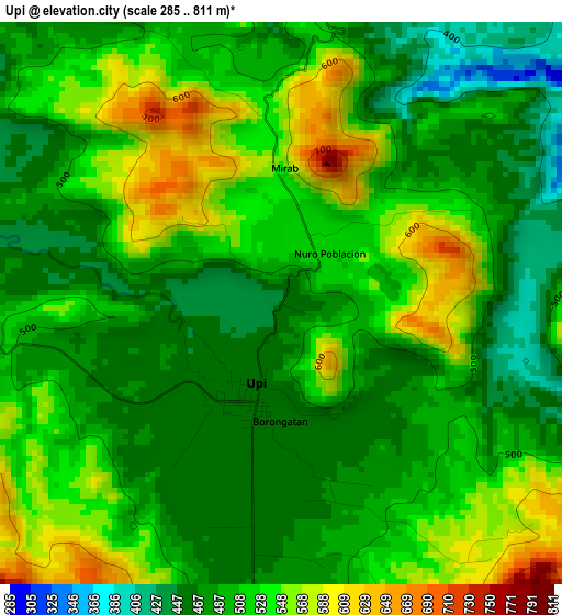
Below is the Elevation map of Upi, which displays elevation range with different colors. Scale of the first map is from 285 to 811 m (935 to 2661 ft) with average elevation of 508.5 meters (=1668 ft) [note 1]
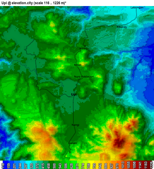
These maps also provides idea of topography and contour of this city, they are displayed at different zoom levels. More info about maps, scale and edge coordinates you can find below images.
| \ | Map #1 | Map #2 | Topo.Map |
| Scale [m] | 285..811 m | 116..1226 m | × |
| Scale [ft] | 935..2661 ft | 381..4022 ft | × |
| Average | 508.5 m = 1668 ft | 498.1 m = 1634 ft | × |
| Width | 9.7 km = 6 mi | 19.4 km = 12.1 mi | 310.3 km = 192.8 mi |
| Height | 9.7 km = 6 mi | 19.4 km = 12.1 mi | 310.4 km = 192.9 mi |
| ↑Max Latitude | 7.069443° | 7.113052° | 8.41929° |
| Latitude at center | 7.02583° | 7.02583° | 7.02583° |
| ↓Min Latitude | 6.982213° | 6.938591° | 5.62818° |
| ← Min Longitude | 124.122725° | 124.078779° | 122.76042° |
| Longitude center | 124.16667° | 124.16667° | 124.16667° |
| →Max Longitude | 124.210615° | 124.254561° | 125.57292° |
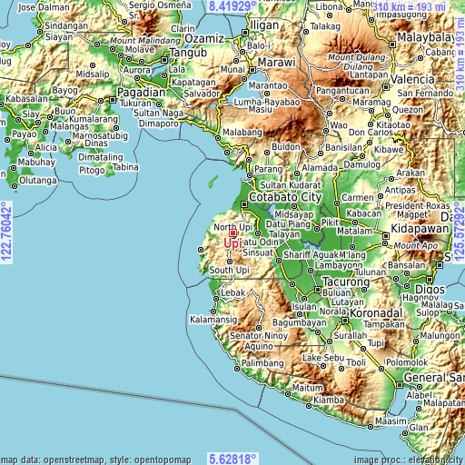
Nearby cities:
Cities around Upi sort by population:
• Cotabato elevation 7 m
23.7 km,  21°
21°
• South Upi 515 m
21.5 km,  184°
184°
• Awang 66 m
15.4 km, 23°
• Tamontaka 8 m
18.4 km, 20°
• Salimbao 10 m
23.9 km, 23°
• Blinsung 469 m
1.8 km,  119°
119°
• Rimpeso 507 m
7.3 km,  268°
268°
• Taviran 5 m
20.1 km,  57°
57°
• Labuñgan 291 m
11.4 km,  41°
41°
• Makir 34 m
15.2 km,  87°
87°
• Dadus 12 m
17.5 km,  78°
78°
• Dinaig 19 m
16.4 km, 90°
Multilingual:
 En español:
Upi elevación 447 m.
 En France:
Upi élévation 447 m.


Sources and notes:
- [note 1] Map square and city borders are not equal. Map elevation data is calculated only from area inside that square.
- [src 1] Elevation data from geonames database provided with same terms of usage.
- [src 2] The elevation map of Upi is generated using elevation data from NASA's 3 arcsec (90m) resolution SRTM data.
- [src 3] Base (background) map © OpenStreetMap contributors tiles are generated by Geofabrik and OpenTopoMap.
Copyright & License:
This Upi Elevation Map is licensed under CC BY-SA. You may reuse any part from this page, if you give a proper credit by linking to this URL:
 More info on terms of use page.