Wawa elevation
Wawa (Mimaropa, Province of Mindoro Occidental), Philippines elevation is 11 meters and Wawa elevation in feet is 36 ft above sea level [src 1]. Wawa is a populated place (feature code) with elevation that is 77 meters (253 ft) smaller than average city elevation in Philippines.
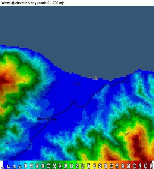
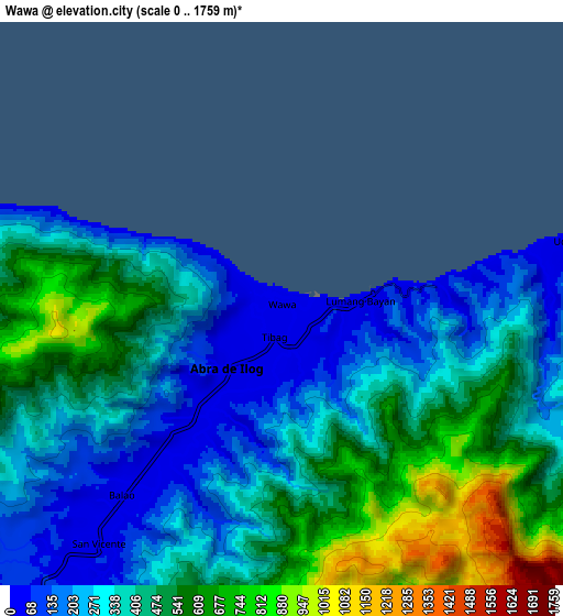
Below is the Elevation map of Wawa, which displays elevation range with different colors. Scale of the first map is from 0 to 700 m (0 to 2297 ft) with average elevation of 157.2 meters (=516 ft) [note 1]
These maps also provides idea of topography and contour of this city, they are displayed at different zoom levels. More info about maps, scale and edge coordinates you can find below images.
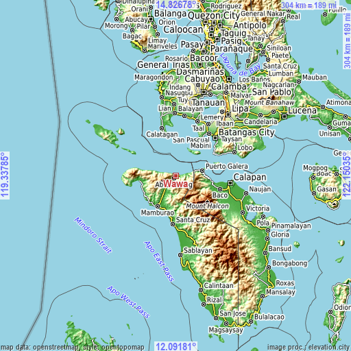
| \ | Map #1 | Map #2 | Topo.Map |
| Scale [m] | 0..700 m | 0..1759 m | × |
| Scale [ft] | 0..2297 ft | 0..5771 ft | × |
| Average | 157.2 m = 516 ft | 405.2 m = 1329 ft | × |
| Width | 9.5 km = 5.9 mi | 19.01 km = 11.8 mi | 304.1 km = 189 mi |
| Height | 9.5 km = 5.9 mi | 19.01 km = 11.8 mi | 304.1 km = 189 mi |
| ↑Max Latitude | 13.505934° | 13.54866° | 14.82678° |
| Latitude at center | 13.4632° | 13.4632° | 13.4632° |
| ↓Min Latitude | 13.420459° | 13.377709° | 12.09181° |
| ← Min Longitude | 120.700155° | 120.656209° | 119.33785° |
| Longitude center | 120.7441° | 120.7441° | 120.7441° |
| →Max Longitude | 120.788045° | 120.831991° | 122.15035° |
Nearby cities:
Cities around Wawa sort by population:
• Mamburao elevation 9 m
31.1 km,  210°
210°
• San Teodoro 73 m
29.4 km,  96°
96°
• Paluan 11 m
30.9 km,  260°
260°
• Cabacao 24 m
16.9 km, 213°
• Balatero 84 m
20 km,  77°
77°
• Puerto Galera 12 m
22.9 km, 79°
• Sabang 12 m
25.3 km, 78°
• Odala 14 m
8.6 km, 79°
• Abra de Ilog 23 m
2.7 km,  216°
216°
• Dulangan 19 m
25.5 km,  88°
88°
• Tingloy 13 m
25.9 km,  31°
31°
• Tabinay 17 m
23.1 km, 83°
Multilingual:
 En español:
Wawa elevación 11 m.
 En France:
Wawa élévation 11 m.


Sources and notes:
- [note 1] Map square and city borders are not equal. Map elevation data is calculated only from area inside that square.
- [src 1] Elevation data from geonames database provided with same terms of usage.
- [src 2] The elevation map of Wawa is generated using elevation data from NASA's 3 arcsec (90m) resolution SRTM data.
- [src 3] Base (background) map © OpenStreetMap contributors tiles are generated by Geofabrik and OpenTopoMap.
Copyright & License:
This Wawa Elevation Map is licensed under CC BY-SA. You may reuse any part from this page, if you give a proper credit by linking to this URL:
 More info on terms of use page.