Punaauia elevation
Punaauia (Îles du Vent), French Polynesia elevation is 24 meters and Punaauia elevation in feet is 79 ft above sea level [src 1]. Punaauia is a populated place (feature code) with elevation that is 0 meters (0 ft) bigger than average city elevation in French Polynesia.
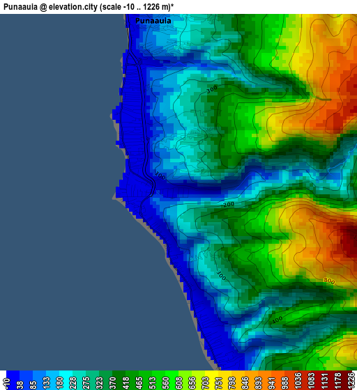
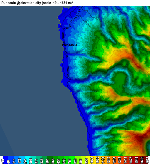
Below is the Elevation map of Punaauia, which displays elevation range with different colors. Scale of the first map is from -10 to 1226 m (-33 to 4022 ft) with average elevation of 388 meters (=1273 ft) [note 1]
These maps also provides idea of topography and contour of this city, they are displayed at different zoom levels. More info about maps, scale and edge coordinates you can find below images.
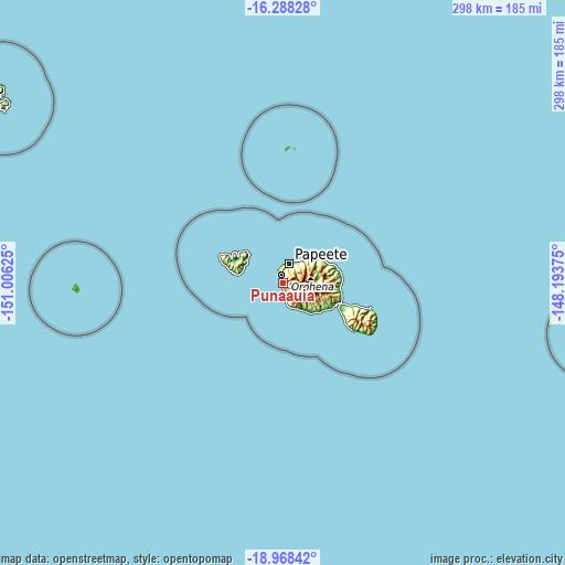
| \ | Map #1 | Map #2 | Topo.Map |
| Scale [m] | -10..1226 m | -19..1671 m | × |
| Scale [ft] | -33..4022 ft | -62..5482 ft | × |
| Average | 388 m = 1273 ft | 508.1 m = 1667 ft | × |
| Width | 9.31 km = 5.8 mi | 18.63 km = 11.6 mi | 298 km = 185.2 mi |
| Height | 9.31 km = 5.8 mi | 18.63 km = 11.6 mi | 298 km = 185.2 mi |
| ↑Max Latitude | -17.591445° | -17.54955° | -16.28828° |
| Latitude at center | -17.63333° | -17.63333° | -17.63333° |
| ↓Min Latitude | -17.675206° | -17.717072° | -18.96842° |
| ← Min Longitude | -149.643945° | -149.687891° | -151.00625° |
| Longitude center | -149.6° | -149.6° | -149.6° |
| →Max Longitude | -149.556055° | -149.512109° | -148.19375° |
Nearby cities:
Cities around Punaauia sort by population:
• Faaa elevation 5 m
9.3 km,  0°
0°
• Papeete 9 m
11.2 km,  18°
18°
• Pirae 7 m
14.8 km,  28°
28°
• Mahina 12 m
18.4 km,  39°
39°
• Paea 16 m
5.8 km,  162°
162°
• Papao 7 m
14 km, 157°
• Arue 94 m
16.8 km, 39°
• Otutara 6 m
25.1 km,  127°
127°
• Paopao 45 m
26.8 km,  298°
298°
• Taunoa 3 m
29 km,  116°
116°
• Afareaitu 16 m
21.5 km, 295°
• Teavaro 27 m
23.1 km,  309°
309°
Multilingual:
 En español:
Punaauia elevación 24 m.
 En France:
Punaauia élévation 24 m.


Sources and notes:
- [note 1] Map square and city borders are not equal. Map elevation data is calculated only from area inside that square.
- [src 1] Elevation data from geonames database provided with same terms of usage.
- [src 2] The elevation map of Punaauia is generated using elevation data from NASA's 3 arcsec (90m) resolution SRTM data.
- [src 3] Base (background) map © OpenStreetMap contributors tiles are generated by Geofabrik and OpenTopoMap.
Copyright & License:
This Punaauia Elevation Map is licensed under CC BY-SA. You may reuse any part from this page, if you give a proper credit by linking to this URL:
 More info on terms of use page.