Río Luís elevation
Río Luís (Veraguas), Panama elevation is 58 meters and Río Luís elevation in feet is 190 ft above sea level [src 1]. Río Luís is a seat of a third-order administrative division (feature code) with elevation that is 114 meters (374 ft) smaller than average city elevation in Panama.
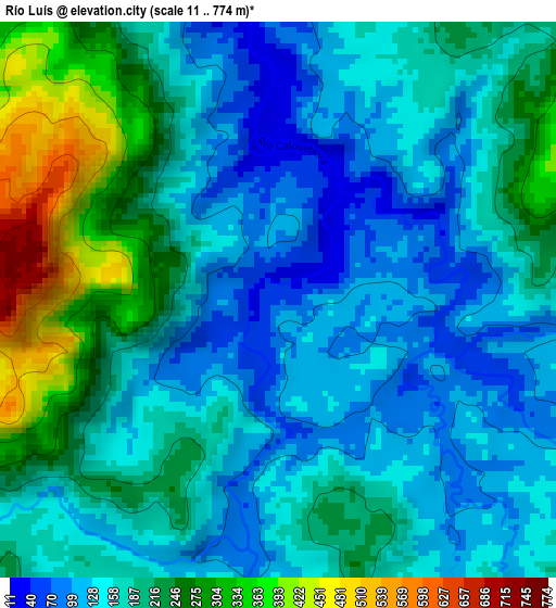
Below is the Elevation map of Río Luís, which displays elevation range with different colors. Scale of the first map is from 11 to 774 m (36 to 2539 ft) with average elevation of 185.2 meters (=608 ft) [note 1]
These maps also provides idea of topography and contour of this city, they are displayed at different zoom levels. More info about maps, scale and edge coordinates you can find below images.
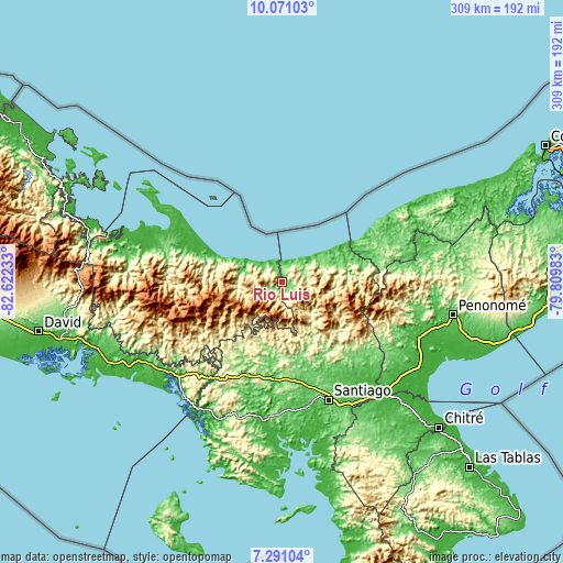
| \ | Map #1 | Topo.Map |
| Scale [m] | 11..774 m | × |
| Scale [ft] | 36..2539 ft | × |
| Average | 185.2 m = 608 ft | × |
| Width | 9.66 km = 6 mi | 309.1 km = 192.1 mi |
| Height | 9.66 km = 6 mi | 309.1 km = 192.1 mi |
| ↑Max Latitude | 8.727049° | 10.07103° |
| Latitude at center | 8.68361° | 8.68361° |
| ↓Min Latitude | 8.640166° | 7.29104° |
| ← Min Longitude | -81.260025° | -82.62233° |
| Longitude center | -81.21608° | -81.21608° |
| →Max Longitude | -81.172135° | -79.80983° |
Nearby cities:
Cities around Río Luís sort by population:
• Santa Fé elevation 429 m
24.5 km,  141°
141°
• Paredón Arriba 435 m
25 km,  174°
174°
• Calovébora 23 m
11.5 km,  3°
3°
• El Pantano 387 m
22.9 km, 135°
• El Alto 621 m
27.5 km,  134°
134°
• Loma Yuca 325 m
21.1 km,  280°
280°
• Gatú 667 m
33.4 km,  119°
119°
• Los Corotúes 324 m
31.8 km,  157°
157°
• Los Valles 391 m
26.2 km,  175°
175°
• Güibale 772 m
24.9 km,  220°
220°
• Santa Catalina 7 m
16.4 km,  311°
311°
• Río Grande 329 m
10.7 km,  228°
228°
Multilingual:
 En español:
Río Luís elevación 58 m.
 En France:
Río Luís élévation 58 m.


Sources and notes:
- [note 1] Map square and city borders are not equal. Map elevation data is calculated only from area inside that square.
- [src 1] Elevation data from geonames database provided with same terms of usage.
- [src 2] The elevation map of Río Luís is generated using elevation data from NASA's 3 arcsec (90m) resolution SRTM data.
- [src 3] Base (background) map © OpenStreetMap contributors tiles are generated by Geofabrik and OpenTopoMap.
Copyright & License:
This Río Luís Elevation Map is licensed under CC BY-SA. You may reuse any part from this page, if you give a proper credit by linking to this URL:
 More info on terms of use page.