Algarrobos Arriba elevation
Algarrobos Arriba (Chiriquí), Panama elevation is 162 meters and Algarrobos Arriba elevation in feet is 531 ft above sea level [src 1]. Algarrobos Arriba is a populated place (feature code) with elevation that is 10 meters (33 ft) smaller than average city elevation in Panama.
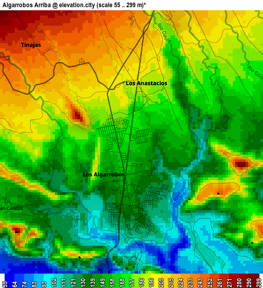
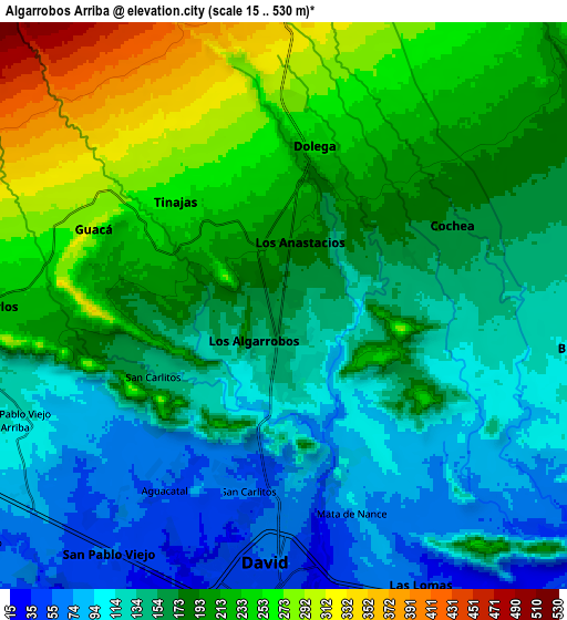
Below is the Elevation map of Algarrobos Arriba, which displays elevation range with different colors. Scale of the first map is from 55 to 299 m (180 to 981 ft) with average elevation of 167.2 meters (=549 ft) [note 1]
These maps also provides idea of topography and contour of this city, they are displayed at different zoom levels. More info about maps, scale and edge coordinates you can find below images.
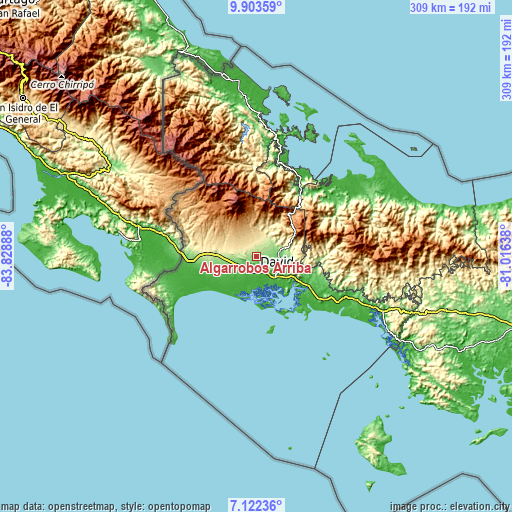
| \ | Map #1 | Map #2 | Topo.Map |
| Scale [m] | 55..299 m | 15..530 m | × |
| Scale [ft] | 180..981 ft | 49..1739 ft | × |
| Average | 167.2 m = 549 ft | 175.5 m = 576 ft | × |
| Width | 9.66 km = 6 mi | 19.33 km = 12 mi | 309.2 km = 192.1 mi |
| Height | 9.66 km = 6 mi | 19.33 km = 12 mi | 309.3 km = 192.2 mi |
| ↑Max Latitude | 8.558958° | 8.602412° | 9.90359° |
| Latitude at center | 8.5155° | 8.5155° | 8.5155° |
| ↓Min Latitude | 8.472037° | 8.428568° | 7.12236° |
| ← Min Longitude | -82.466575° | -82.510521° | -83.82888° |
| Longitude center | -82.42263° | -82.42263° | -82.42263° |
| →Max Longitude | -82.378685° | -82.334739° | -81.01638° |
Nearby cities:
Cities around Algarrobos Arriba sort by population:
• Los Algarrobos elevation 144 m
2.2 km,  184°
184°
• Nuevo San Carlitos 61 m
6.7 km,  193°
193°
• Dolega District 247 m
5.8 km,  9°
9°
• Quinteño 104 m
5.9 km,  147°
147°
• Los Anastacios 179 m
1.6 km,  358°
358°
• Caimito 207 m
2.9 km, 7°
• Mata del Nance 83 m
7.6 km,  161°
161°
• Tinajas 273 m
5.8 km,  315°
315°
• Guaca Arriba 269 m
8.1 km,  287°
287°
• Cochea Abajo 127 m
7.1 km,  99°
99°
• San Carlos 226 m
9.5 km,  270°
270°
• Dos Ríos Abajo 155 m
4.2 km,  70°
70°
Multilingual:
 En español:
Algarrobos Arriba elevación 162 m.
 En France:
Algarrobos Arriba élévation 162 m.
 Auf Deutsch:
Algarrobos Arriba höhe über dem Meeresspiegel ist 162 m.

Sources and notes:
- [note 1] Map square and city borders are not equal. Map elevation data is calculated only from area inside that square.
- [src 1] Elevation data from geonames database provided with same terms of usage.
- [src 2] The elevation map of Algarrobos Arriba is generated using elevation data from NASA's 3 arcsec (90m) resolution SRTM data.
- [src 3] Base (background) map © OpenStreetMap contributors tiles are generated by Geofabrik and OpenTopoMap.
Copyright & License:
This Algarrobos Arriba Elevation Map is licensed under CC BY-SA. You may reuse any part from this page, if you give a proper credit by linking to this URL:
 More info on terms of use page.