Antón elevation
Antón (Coclé), Panama elevation is 24 meters and Antón elevation in feet is 79 ft above sea level [src 1]. Antón is a seat of a second-order administrative division (feature code) with elevation that is 148 meters (486 ft) smaller than average city elevation in Panama.
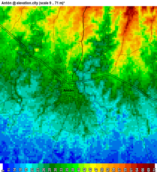
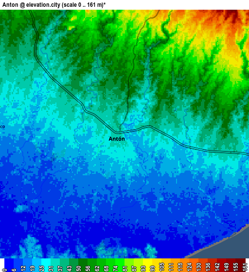
Below is the Elevation map of Antón, which displays elevation range with different colors. Scale of the first map is from 9 to 71 m (30 to 233 ft) with average elevation of 30.1 meters (=99 ft) [note 1]
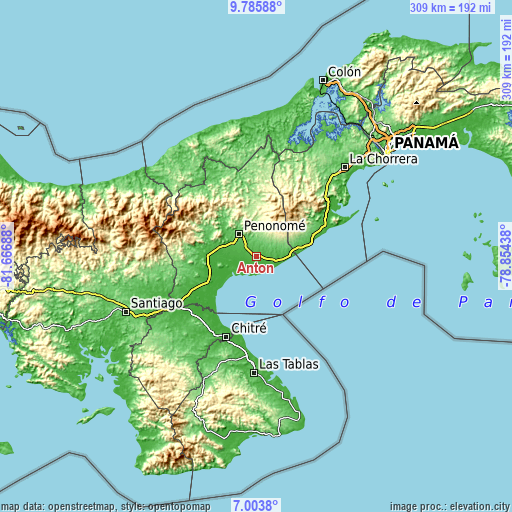
These maps also provides idea of topography and contour of this city, they are displayed at different zoom levels. More info about maps, scale and edge coordinates you can find below images.
| \ | Map #1 | Map #2 | Topo.Map |
| Scale [m] | 9..71 m | 0..161 m | × |
| Scale [ft] | 30..233 ft | 0..528 ft | × |
| Average | 30.1 m = 99 ft | 35.4 m = 116 ft | × |
| Width | 9.67 km = 6 mi | 19.34 km = 12 mi | 309.3 km = 192.2 mi |
| Height | 9.67 km = 6 mi | 19.34 km = 12 mi | 309.4 km = 192.3 mi |
| ↑Max Latitude | 8.440802° | 8.484269° | 9.78588° |
| Latitude at center | 8.39733° | 8.39733° | 8.39733° |
| ↓Min Latitude | 8.353853° | 8.310372° | 7.0038° |
| ← Min Longitude | -80.304575° | -80.348521° | -81.66688° |
| Longitude center | -80.26063° | -80.26063° | -80.26063° |
| →Max Longitude | -80.216685° | -80.172739° | -78.85438° |
Nearby cities:
Cities around Antón sort by population:
• Penonomé elevation 90 m
17.2 km,  321°
321°
• Río Hato 37 m
10.6 km,  100°
100°
• Farallón 9 m
14.3 km,  108°
108°
• Juan Díaz 63 m
7.6 km,  341°
341°
• Llano Marín 56 m
11.3 km, 321°
• Los Pollos 49 m
11.4 km,  89°
89°
• Aguas Blancas 77 m
13.1 km,  334°
334°
• El Coco 24 m
9.8 km,  269°
269°
• El Chirú 50 m
8.1 km, 88°
• El Retiro 163 m
14.9 km,  51°
51°
• Santa Rita 176 m
13.6 km,  38°
38°
• Llano Grande 79 m
7 km,  32°
32°
Multilingual:
 En español:
Antón elevación 24 m.
 En France:
Antón élévation 24 m.


Sources and notes:
- [note 1] Map square and city borders are not equal. Map elevation data is calculated only from area inside that square.
- [src 1] Elevation data from geonames database provided with same terms of usage.
- [src 2] The elevation map of Antón is generated using elevation data from NASA's 3 arcsec (90m) resolution SRTM data.
- [src 3] Base (background) map © OpenStreetMap contributors tiles are generated by Geofabrik and OpenTopoMap.
Copyright & License:
This Antón Elevation Map is licensed under CC BY-SA. You may reuse any part from this page, if you give a proper credit by linking to this URL:
 More info on terms of use page.