Arenosa elevation
Arenosa (Panamá Oeste), Panama elevation is 28 meters and Arenosa elevation in feet is 92 ft above sea level [src 1]. Arenosa is a seat of a third-order administrative division (feature code) with elevation that is 144 meters (472 ft) smaller than average city elevation in Panama.
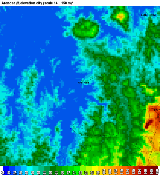
Below is the Elevation map of Arenosa, which displays elevation range with different colors. Scale of the first map is from 14 to 150 m (46 to 492 ft) with average elevation of 45.1 meters (=148 ft) [note 1]
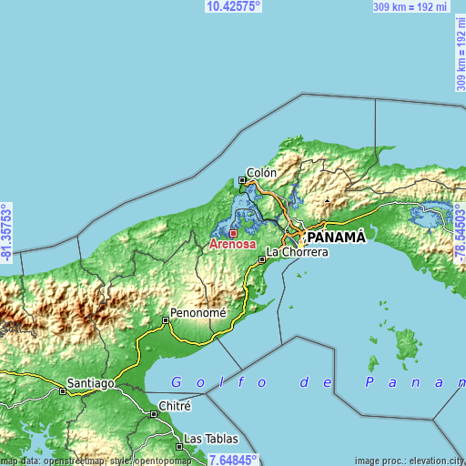
These maps also provides idea of topography and contour of this city, they are displayed at different zoom levels. More info about maps, scale and edge coordinates you can find below images.
| \ | Map #1 | Topo.Map |
| Scale [m] | 14..150 m | × |
| Scale [ft] | 46..492 ft | × |
| Average | 45.1 m = 148 ft | × |
| Width | 9.65 km = 6 mi | 308.8 km = 191.9 mi |
| Height | 9.65 km = 6 mi | 308.8 km = 191.9 mi |
| ↑Max Latitude | 9.083177° | 10.42575° |
| Latitude at center | 9.03978° | 9.03978° |
| ↓Min Latitude | 8.996378° | 7.64845° |
| ← Min Longitude | -79.995225° | -81.35753° |
| Longitude center | -79.95128° | -79.95128° |
| →Max Longitude | -79.907335° | -78.54503° |
Nearby cities:
Cities around Arenosa sort by population:
• Escobal elevation 48 m
11.6 km,  352°
352°
• Cerro Cama 119 m
5 km,  105°
105°
• Mendoza 123 m
11.4 km,  104°
104°
• El Guabo 72 m
15.1 km,  286°
286°
• La Laguna 30 m
12 km,  87°
87°
• Nueva Arenosa 126 m
19.5 km,  194°
194°
• Cirí de Los Sotos 84 m
17.2 km,  244°
244°
• Arosemena 77 m
7.8 km, 192°
• Achiote 17 m
20.2 km,  340°
340°
• Zangüengas 114 m
12.9 km,  136°
136°
• Cuipo 28 m
11.2 km, 286°
• Lagarterita 38 m
6 km,  42°
42°
Multilingual:
 En español:
Arenosa elevación 28 m.
 En France:
Arenosa élévation 28 m.


Sources and notes:
- [note 1] Map square and city borders are not equal. Map elevation data is calculated only from area inside that square.
- [src 1] Elevation data from geonames database provided with same terms of usage.
- [src 2] The elevation map of Arenosa is generated using elevation data from NASA's 3 arcsec (90m) resolution SRTM data.
- [src 3] Base (background) map © OpenStreetMap contributors tiles are generated by Geofabrik and OpenTopoMap.
Copyright & License:
This Arenosa Elevation Map is licensed under CC BY-SA. You may reuse any part from this page, if you give a proper credit by linking to this URL:
 More info on terms of use page.