Ave María elevation
Ave María (Los Santos), Panama elevation is 41 meters and Ave María elevation in feet is 135 ft above sea level [src 1]. Ave María is a seat of a third-order administrative division (feature code) with elevation that is 131 meters (430 ft) smaller than average city elevation in Panama.
Below is the Elevation map of Ave María, which displays elevation range with different colors. Scale of the first map is from 3 to 611 m (10 to 2005 ft) with average elevation of 120.1 meters (=394 ft) [note 1]
These maps also provides idea of topography and contour of this city, they are displayed at different zoom levels. More info about maps, scale and edge coordinates you can find below images.
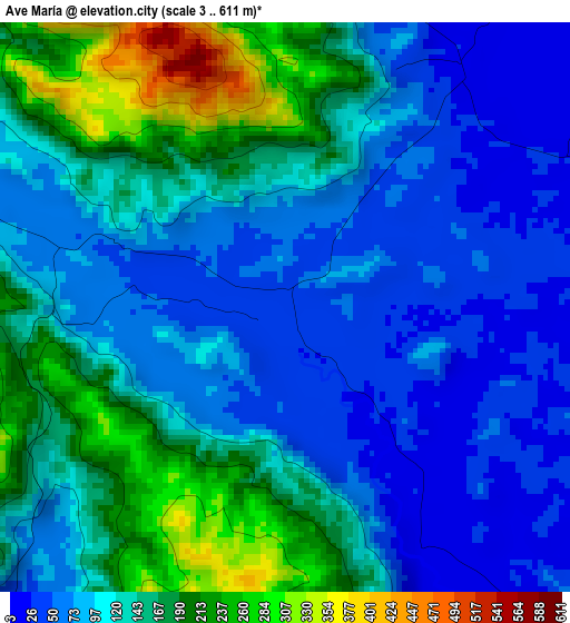
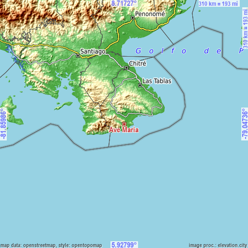
| \ | Map #1 | Topo.Map |
| Scale [m] | 3..611 m | × |
| Scale [ft] | 10..2005 ft | × |
| Average | 120.1 m = 394 ft | × |
| Width | 9.69 km = 6 mi | 310.1 km = 192.7 mi |
| Height | 9.69 km = 6 mi | 310.2 km = 192.7 mi |
| ↑Max Latitude | 7.368395° | 8.71727° |
| Latitude at center | 7.32481° | 7.32481° |
| ↓Min Latitude | 7.281221° | 5.92799° |
| ← Min Longitude | -80.497555° | -81.85986° |
| Longitude center | -80.45361° | -80.45361° |
| →Max Longitude | -80.409665° | -79.04736° |
Nearby cities:
Cities around Ave María sort by population:
• Tonosí elevation 19 m
9.2 km,  7°
7°
• Flores 29 m
18.2 km,  16°
16°
• Cambutal 18 m
7.8 km,  211°
211°
• Cañas 12 m
24.9 km,  56°
56°
• El Cacao 14 m
14.3 km, 19°
• El Cortezo 150 m
22.8 km,  299°
299°
• La Miel 168 m
29.6 km,  28°
28°
• Nuario 404 m
26.8 km, 31°
• La Tronosa 97 m
19.2 km,  310°
310°
• Bajos de Güera 114 m
30.8 km,  322°
322°
• Altos de Güera 203 m
29.4 km, 321°
• El Bebedero 19 m
9.4 km,  358°
358°
Multilingual:
 En español:
Ave María elevación 41 m.
 En France:
Ave María élévation 41 m.
 Auf Deutsch:
Ave María höhe über dem Meeresspiegel ist 41 m.

Sources and notes:
- [note 1] Map square and city borders are not equal. Map elevation data is calculated only from area inside that square.
- [src 1] Elevation data from geonames database provided with same terms of usage.
- [src 2] The elevation map of Ave María is generated using elevation data from NASA's 3 arcsec (90m) resolution SRTM data.
- [src 3] Base (background) map © OpenStreetMap contributors tiles are generated by Geofabrik and OpenTopoMap.
Copyright & License:
This Ave María Elevation Map is licensed under CC BY-SA. You may reuse any part from this page, if you give a proper credit by linking to this URL:
 More info on terms of use page.