Bahía Honda elevation
Bahía Honda (Los Santos), Panama elevation is 284 meters and Bahía Honda elevation in feet is 932 ft above sea level [src 1]. Bahía Honda is a seat of a third-order administrative division (feature code) with elevation that is 112 meters (367 ft) bigger than average city elevation in Panama.
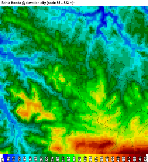
Below is the Elevation map of Bahía Honda, which displays elevation range with different colors. Scale of the first map is from 85 to 523 m (279 to 1716 ft) with average elevation of 241.6 meters (=793 ft) [note 1]
These maps also provides idea of topography and contour of this city, they are displayed at different zoom levels. More info about maps, scale and edge coordinates you can find below images.
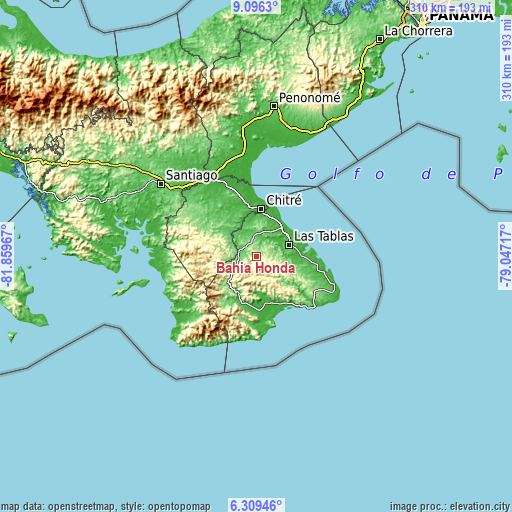
| \ | Map #1 | Topo.Map |
| Scale [m] | 85..523 m | × |
| Scale [ft] | 279..1716 ft | × |
| Average | 241.6 m = 793 ft | × |
| Width | 9.68 km = 6 mi | 309.9 km = 192.6 mi |
| Height | 9.68 km = 6 mi | 309.9 km = 192.6 mi |
| ↑Max Latitude | 7.748716° | 9.0963° |
| Latitude at center | 7.70517° | 7.70517° |
| ↓Min Latitude | 7.661619° | 6.30946° |
| ← Min Longitude | -80.497365° | -81.85967° |
| Longitude center | -80.45342° | -80.45342° |
| →Max Longitude | -80.409475° | -79.04717° |
Nearby cities:
Cities around Bahía Honda sort by population:
• Macaracas elevation 108 m
11.4 km,  284°
284°
• La Palma 193 m
7.8 km,  80°
80°
• Llano Abajo 65 m
10.1 km,  27°
27°
• Bayano 254 m
11.5 km,  136°
136°
• Las Trancas 145 m
9.3 km,  69°
69°
• Cedro Arriba 145 m
12 km,  314°
314°
• Palmira 301 m
11.6 km,  113°
113°
• Mogollón 414 m
7 km,  185°
185°
• Río Hondo 179 m
10.4 km,  85°
85°
• El Macano 288 m
6 km, 112°
• Las Palmas 157 m
5.4 km,  243°
243°
• El Espino Amarillo 320 m
3.6 km,  153°
153°
Multilingual:
 En español:
Bahía Honda elevación 284 m.
 En France:
Bahía Honda élévation 284 m.
 Auf Deutsch:
Bahía Honda höhe über dem Meeresspiegel ist 284 m.

Sources and notes:
- [note 1] Map square and city borders are not equal. Map elevation data is calculated only from area inside that square.
- [src 1] Elevation data from geonames database provided with same terms of usage.
- [src 2] The elevation map of Bahía Honda is generated using elevation data from NASA's 3 arcsec (90m) resolution SRTM data.
- [src 3] Base (background) map © OpenStreetMap contributors tiles are generated by Geofabrik and OpenTopoMap.
Copyright & License:
This Bahía Honda Elevation Map is licensed under CC BY-SA. You may reuse any part from this page, if you give a proper credit by linking to this URL:
 More info on terms of use page.