Bajo Corral elevation
Bajo Corral (Los Santos), Panama elevation is 176 meters and Bajo Corral elevation in feet is 577 ft above sea level [src 1]. Bajo Corral is a seat of a third-order administrative division (feature code) with elevation that is 4 meters (13 ft) bigger than average city elevation in Panama.
Below is the Elevation map of Bajo Corral, which displays elevation range with different colors. Scale of the first map is from 56 to 459 m (184 to 1506 ft) with average elevation of 200 meters (=656 ft) [note 1]
These maps also provides idea of topography and contour of this city, they are displayed at different zoom levels. More info about maps, scale and edge coordinates you can find below images.
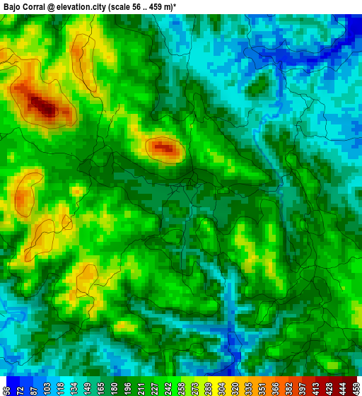
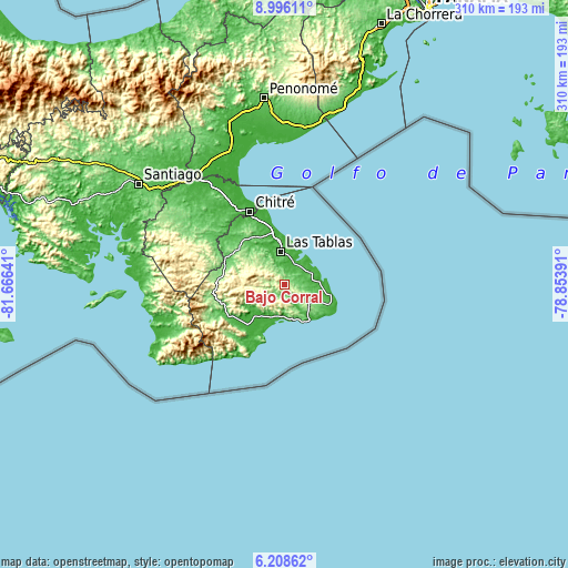
| \ | Map #1 | Topo.Map |
| Scale [m] | 56..459 m | × |
| Scale [ft] | 184..1506 ft | × |
| Average | 200 m = 656 ft | × |
| Width | 9.69 km = 6 mi | 309.9 km = 192.6 mi |
| Height | 9.69 km = 6 mi | 310 km = 192.6 mi |
| ↑Max Latitude | 7.648187° | 8.99611° |
| Latitude at center | 7.60463° | 7.60463° |
| ↓Min Latitude | 7.561069° | 6.20862° |
| ← Min Longitude | -80.304105° | -81.66641° |
| Longitude center | -80.26016° | -80.26016° |
| →Max Longitude | -80.216215° | -78.85391° |
Nearby cities:
Cities around Bajo Corral sort by population:
• La Palma elevation 38 m
11.7 km,  36°
36°
• Paritilla 77 m
10 km,  74°
74°
• San José 49 m
7.9 km,  12°
12°
• El Pedregoso 176 m
12.2 km,  322°
322°
• Vallerriquito 200 m
6.8 km,  286°
286°
• Valle Rico 193 m
10.1 km,  279°
279°
• El Muñoz 202 m
10.4 km, 319°
• El Cañafístulo 157 m
3.3 km,  63°
63°
• Oria Arriba 27 m
12.6 km,  151°
151°
• La Miel 168 m
8.9 km,  236°
236°
• Palmira 301 m
12.5 km,  301°
301°
• Nuario 404 m
11.1 km,  221°
221°
Multilingual:
 En español:
Bajo Corral elevación 176 m.
 En France:
Bajo Corral élévation 176 m.
 Auf Deutsch:
Bajo Corral höhe über dem Meeresspiegel ist 176 m.

Sources and notes:
- [note 1] Map square and city borders are not equal. Map elevation data is calculated only from area inside that square.
- [src 1] Elevation data from geonames database provided with same terms of usage.
- [src 2] The elevation map of Bajo Corral is generated using elevation data from NASA's 3 arcsec (90m) resolution SRTM data.
- [src 3] Base (background) map © OpenStreetMap contributors tiles are generated by Geofabrik and OpenTopoMap.
Copyright & License:
This Bajo Corral Elevation Map is licensed under CC BY-SA. You may reuse any part from this page, if you give a proper credit by linking to this URL:
 More info on terms of use page.