Boca Chica elevation
Boca Chica (Chiriquí), Panama elevation is 19 meters and Boca Chica elevation in feet is 62 ft above sea level [src 1]. Boca Chica is a seat of a third-order administrative division (feature code) with elevation that is 153 meters (502 ft) smaller than average city elevation in Panama.
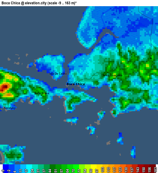
Below is the Elevation map of Boca Chica, which displays elevation range with different colors. Scale of the first map is from -9 to 163 m (-30 to 535 ft) with average elevation of 25.7 meters (=84 ft) [note 1]
These maps also provides idea of topography and contour of this city, they are displayed at different zoom levels. More info about maps, scale and edge coordinates you can find below images.
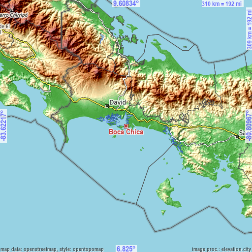
| \ | Map #1 | Topo.Map |
| Scale [m] | -9..163 m | × |
| Scale [ft] | -30..535 ft | × |
| Average | 25.7 m = 84 ft | × |
| Width | 9.67 km = 6 mi | 309.5 km = 192.3 mi |
| Height | 9.67 km = 6 mi | 309.5 km = 192.3 mi |
| ↑Max Latitude | 8.262602° | 9.60834° |
| Latitude at center | 8.21911° | 8.21911° |
| ↓Min Latitude | 8.175614° | 6.825° |
| ← Min Longitude | -82.259865° | -83.62217° |
| Longitude center | -82.21592° | -82.21592° |
| →Max Longitude | -82.171975° | -80.80967° |
Nearby cities:
Cities around Boca Chica sort by population:
• Pedregal elevation 4 m
29.1 km,  304°
304°
• Las Lomas 68 m
30 km,  321°
321°
• Chiriquí 36 m
22.5 km,  329°
329°
• San Lorenzo 38 m
15.9 km,  52°
52°
• Horconcitos 35 m
12.5 km,  34°
34°
• Rincón 63 m
28.1 km,  345°
345°
• Camarón Arriba 432 m
30.5 km, 53°
• Plan de Chorcha 256 m
27.7 km,  13°
13°
• Boca del Monte 72 m
18.6 km,  37°
37°
• Hato Corotú 160 m
29.9 km,  64°
64°
• Juay 8 m
30.5 km,  76°
76°
• San Juan 39 m
25.3 km, 75°
Multilingual:
 En español:
Boca Chica elevación 19 m.
 En France:
Boca Chica élévation 19 m.
 Auf Deutsch:
Boca Chica höhe über dem Meeresspiegel ist 19 m.

Sources and notes:
- [note 1] Map square and city borders are not equal. Map elevation data is calculated only from area inside that square.
- [src 1] Elevation data from geonames database provided with same terms of usage.
- [src 2] The elevation map of Boca Chica is generated using elevation data from NASA's 3 arcsec (90m) resolution SRTM data.
- [src 3] Base (background) map © OpenStreetMap contributors tiles are generated by Geofabrik and OpenTopoMap.
Copyright & License:
This Boca Chica Elevation Map is licensed under CC BY-SA. You may reuse any part from this page, if you give a proper credit by linking to this URL:
 More info on terms of use page.