Cacique elevation
Cacique (Colón), Panama elevation is 14 meters and Cacique elevation in feet is 46 ft above sea level [src 1]. Cacique is a seat of a third-order administrative division (feature code) with elevation that is 158 meters (518 ft) smaller than average city elevation in Panama.
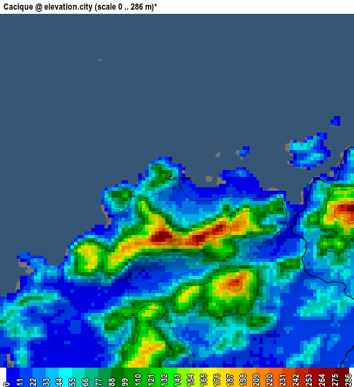
Below is the Elevation map of Cacique, which displays elevation range with different colors. Scale of the first map is from 0 to 286 m (0 to 938 ft) with average elevation of 60.2 meters (=198 ft) [note 1]
These maps also provides idea of topography and contour of this city, they are displayed at different zoom levels. More info about maps, scale and edge coordinates you can find below images.
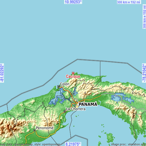
| \ | Map #1 | Topo.Map |
| Scale [m] | 0..286 m | × |
| Scale [ft] | 0..938 ft | × |
| Average | 60.2 m = 198 ft | × |
| Width | 9.64 km = 6 mi | 308.3 km = 191.6 mi |
| Height | 9.64 km = 6 mi | 308.3 km = 191.6 mi |
| ↑Max Latitude | 9.652306° | 10.99253° |
| Latitude at center | 9.60898° | 9.60898° |
| ↓Min Latitude | 9.565648° | 8.21975° |
| ← Min Longitude | -79.660615° | -81.02292° |
| Longitude center | -79.61667° | -79.61667° |
| →Max Longitude | -79.572725° | -78.21042° |
Nearby cities:
Cities around Cacique sort by population:
• Puerto Pilón elevation 22 m
33.5 km,  215°
215°
• Río Alejandro 22 m
32.4 km, 215°
• Quebrada Bonita Adentro 137 m
36.1 km,  195°
195°
• Portobelo 11 m
7.6 km, 215°
• María Chiquita 6 m
24.1 km, 218°
• Nombre de Dios 12 m
16.3 km,  101°
101°
• Viento Frío 4 m
23.2 km, 97°
• Palenque 12 m
28.1 km, 98°
• Miramar 4 m
31 km, 96°
• Playa Chiquita 5 m
35.9 km, 97°
• Sardinilla 71 m
34.6 km,  184°
184°
• Cuango 11 m
33.2 km, 98°
Multilingual:
 En español:
Cacique elevación 14 m.
 En France:
Cacique élévation 14 m.


Sources and notes:
- [note 1] Map square and city borders are not equal. Map elevation data is calculated only from area inside that square.
- [src 1] Elevation data from geonames database provided with same terms of usage.
- [src 2] The elevation map of Cacique is generated using elevation data from NASA's 3 arcsec (90m) resolution SRTM data.
- [src 3] Base (background) map © OpenStreetMap contributors tiles are generated by Geofabrik and OpenTopoMap.
Copyright & License:
This Cacique Elevation Map is licensed under CC BY-SA. You may reuse any part from this page, if you give a proper credit by linking to this URL:
 More info on terms of use page.