Cerro Viejo elevation
Cerro Viejo (Chiriquí), Panama elevation is 434 meters and Cerro Viejo elevation in feet is 1424 ft above sea level [src 1]. Cerro Viejo is a seat of a third-order administrative division (feature code) with elevation that is 262 meters (860 ft) bigger than average city elevation in Panama.
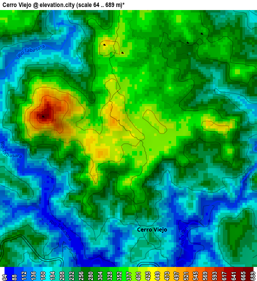
Below is the Elevation map of Cerro Viejo, which displays elevation range with different colors. Scale of the first map is from 64 to 689 m (210 to 2260 ft) with average elevation of 262.3 meters (=861 ft) [note 1]
These maps also provides idea of topography and contour of this city, they are displayed at different zoom levels. More info about maps, scale and edge coordinates you can find below images.
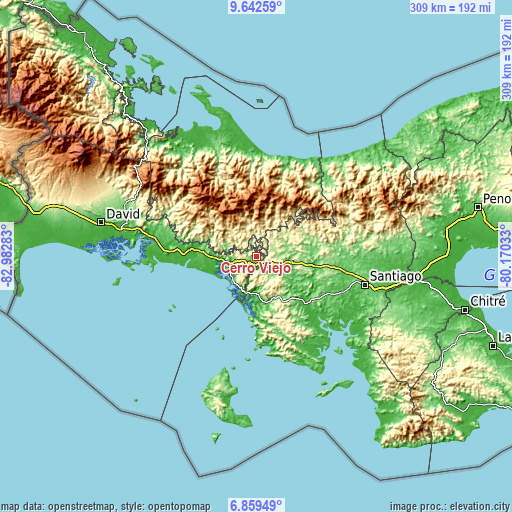
| \ | Map #1 | Topo.Map |
| Scale [m] | 64..689 m | × |
| Scale [ft] | 210..2260 ft | × |
| Average | 262.3 m = 861 ft | × |
| Width | 9.67 km = 6 mi | 309.5 km = 192.3 mi |
| Height | 9.67 km = 6 mi | 309.5 km = 192.3 mi |
| ↑Max Latitude | 8.296978° | 9.64259° |
| Latitude at center | 8.25349° | 8.25349° |
| ↓Min Latitude | 8.209997° | 6.85949° |
| ← Min Longitude | -81.620525° | -82.98283° |
| Longitude center | -81.57658° | -81.57658° |
| →Max Longitude | -81.532635° | -80.17033° |
Nearby cities:
Cities around Cerro Viejo sort by population:
• Tolé elevation 309 m
10.6 km,  261°
261°
• Pueblo Viejo 339 m
9.5 km,  268°
268°
• Veladero 286 m
8.9 km,  253°
253°
• Alto de Jesús 338 m
10.2 km,  84°
84°
• Cerro Caña 429 m
11.5 km,  341°
341°
• Alto Caballero 446 m
11.4 km,  290°
290°
• Cerro Pelado 254 m
10.9 km,  157°
157°
• El Prado 350 m
8.2 km,  102°
102°
• Cerro Iglesias 497 m
7.4 km,  10°
10°
• El Piro 237 m
7.3 km,  131°
131°
• Bella Vista 256 m
7.2 km,  223°
223°
• Cerro Venado 273 m
2.8 km,  174°
174°
Multilingual:
 En español:
Cerro Viejo elevación 434 m.
 En France:
Cerro Viejo élévation 434 m.
 Auf Deutsch:
Cerro Viejo höhe über dem Meeresspiegel ist 434 m.

Sources and notes:
- [note 1] Map square and city borders are not equal. Map elevation data is calculated only from area inside that square.
- [src 1] Elevation data from geonames database provided with same terms of usage.
- [src 2] The elevation map of Cerro Viejo is generated using elevation data from NASA's 3 arcsec (90m) resolution SRTM data.
- [src 3] Base (background) map © OpenStreetMap contributors tiles are generated by Geofabrik and OpenTopoMap.
Copyright & License:
This Cerro Viejo Elevation Map is licensed under CC BY-SA. You may reuse any part from this page, if you give a proper credit by linking to this URL:
 More info on terms of use page.