El Nancito elevation
El Nancito (Chiriquí), Panama elevation is 226 meters and El Nancito elevation in feet is 741 ft above sea level [src 1]. El Nancito is a seat of a third-order administrative division (feature code) with elevation that is 54 meters (177 ft) bigger than average city elevation in Panama.
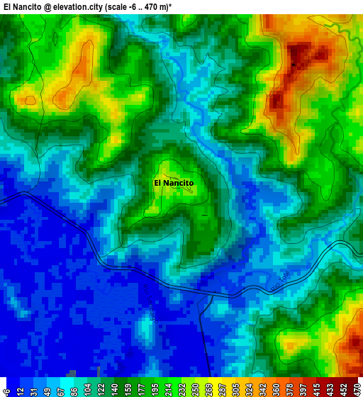
Below is the Elevation map of El Nancito, which displays elevation range with different colors. Scale of the first map is from -6 to 470 m (-20 to 1542 ft) with average elevation of 129.3 meters (=424 ft) [note 1]
These maps also provides idea of topography and contour of this city, they are displayed at different zoom levels. More info about maps, scale and edge coordinates you can find below images.
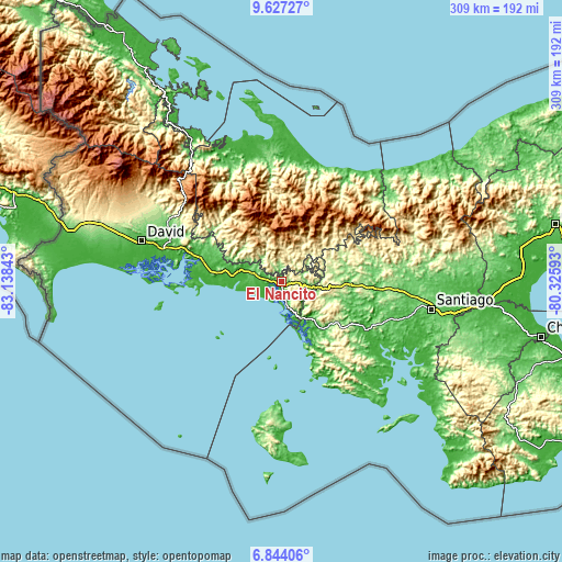
| \ | Map #1 | Topo.Map |
| Scale [m] | -6..470 m | × |
| Scale [ft] | -20..1542 ft | × |
| Average | 129.3 m = 424 ft | × |
| Width | 9.67 km = 6 mi | 309.5 km = 192.3 mi |
| Height | 9.67 km = 6 mi | 309.5 km = 192.3 mi |
| ↑Max Latitude | 8.281599° | 9.62727° |
| Latitude at center | 8.23811° | 8.23811° |
| ↓Min Latitude | 8.194616° | 6.84406° |
| ← Min Longitude | -81.776125° | -83.13843° |
| Longitude center | -81.73218° | -81.73218° |
| →Max Longitude | -81.688235° | -80.32593° |
Nearby cities:
Cities around El Nancito sort by population:
• Tolé elevation 309 m
6.7 km,  88°
88°
• Pueblo Viejo 339 m
7.8 km,  79°
79°
• Veladero 286 m
8.6 km, 94°
• Remedios 39 m
10.6 km,  261°
261°
• Lajero Arriba 233 m
7.2 km,  324°
324°
• Lajas de Tolé 340 m
8.5 km,  152°
152°
• Santa Lucia 46 m
10.4 km,  265°
265°
• Cabecera de Cerro Puerco 331 m
9.4 km,  341°
341°
• Cerro Iglesias 369 m
8.9 km,  305°
305°
• El Puerto 18 m
8.8 km,  251°
251°
• Alto Caballero 446 m
8.7 km,  48°
48°
• Potrero de Caña 456 m
7.2 km,  30°
30°
Multilingual:
 En español:
El Nancito elevación 226 m.
 En France:
El Nancito élévation 226 m.
 Auf Deutsch:
El Nancito höhe über dem Meeresspiegel ist 226 m.

Sources and notes:
- [note 1] Map square and city borders are not equal. Map elevation data is calculated only from area inside that square.
- [src 1] Elevation data from geonames database provided with same terms of usage.
- [src 2] The elevation map of El Nancito is generated using elevation data from NASA's 3 arcsec (90m) resolution SRTM data.
- [src 3] Base (background) map © OpenStreetMap contributors tiles are generated by Geofabrik and OpenTopoMap.
Copyright & License:
This El Nancito Elevation Map is licensed under CC BY-SA. You may reuse any part from this page, if you give a proper credit by linking to this URL:
 More info on terms of use page.