Hato Juli elevation
Hato Juli (Ngöbe-Buglé), Panama elevation is 372 meters and Hato Juli elevation in feet is 1220 ft above sea level [src 1]. Hato Juli is a seat of a third-order administrative division (feature code) with elevation that is 200 meters (656 ft) bigger than average city elevation in Panama.
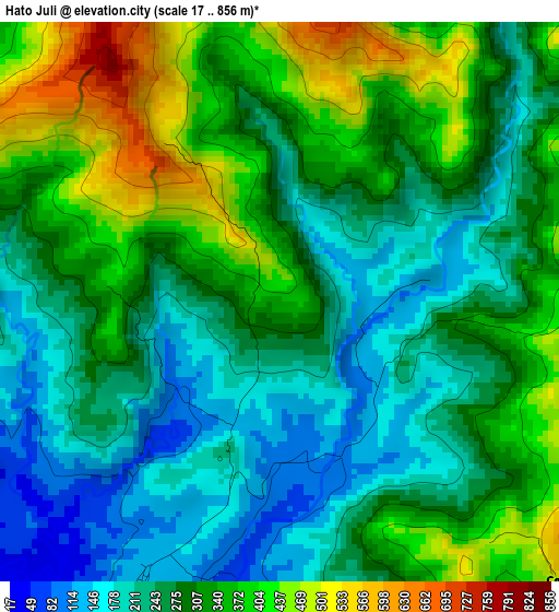
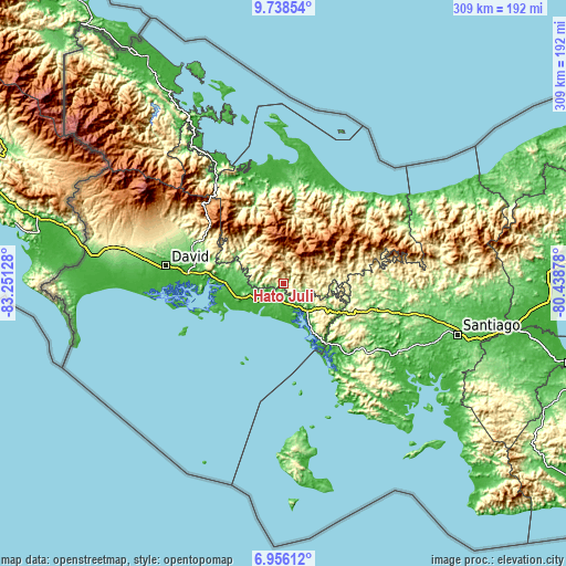
Below is the Elevation map of Hato Juli, which displays elevation range with different colors. Scale of the first map is from 17 to 856 m (56 to 2808 ft) with average elevation of 294.7 meters (=967 ft) [note 1]
These maps also provides idea of topography and contour of this city, they are displayed at different zoom levels. More info about maps, scale and edge coordinates you can find below images.
| \ | Map #1 | Topo.Map |
| Scale [m] | 17..856 m | × |
| Scale [ft] | 56..2808 ft | × |
| Average | 294.7 m = 967 ft | × |
| Width | 9.67 km = 6 mi | 309.4 km = 192.3 mi |
| Height | 9.67 km = 6 mi | 309.4 km = 192.3 mi |
| ↑Max Latitude | 8.393287° | 9.73854° |
| Latitude at center | 8.34981° | 8.34981° |
| ↓Min Latitude | 8.306328° | 6.95612° |
| ← Min Longitude | -81.888975° | -83.25128° |
| Longitude center | -81.84503° | -81.84503° |
| →Max Longitude | -81.801085° | -80.43878° |
Nearby cities:
Cities around Hato Juli sort by population:
• Quebrada Canoa elevation 669 m
11.5 km,  36°
36°
• San Félix 102 m
7 km,  200°
200°
• Las Lajas 69 m
12.3 km,  192°
192°
• Lajero Arriba 233 m
10.5 km,  128°
128°
• Oma 436 m
4.8 km,  89°
89°
• Lajas Adentro 60 m
11.7 km, 197°
• Cabecera de Cerro Puerco 331 m
10 km,  110°
110°
• Quebrada de Loro 371 m
9.1 km,  276°
276°
• Cerro Iglesias 369 m
8.8 km,  144°
144°
• Hato Jobo 463 m
6.5 km,  315°
315°
• Hato Pilón 589 m
5.8 km,  337°
337°
• Salto Dupí 159 m
4.6 km,  272°
272°
Multilingual:
 En español:
Hato Juli elevación 372 m.
 En France:
Hato Juli élévation 372 m.
 Auf Deutsch:
Hato Juli höhe über dem Meeresspiegel ist 372 m.

Sources and notes:
- [note 1] Map square and city borders are not equal. Map elevation data is calculated only from area inside that square.
- [src 1] Elevation data from geonames database provided with same terms of usage.
- [src 2] The elevation map of Hato Juli is generated using elevation data from NASA's 3 arcsec (90m) resolution SRTM data.
- [src 3] Base (background) map © OpenStreetMap contributors tiles are generated by Geofabrik and OpenTopoMap.
Copyright & License:
This Hato Juli Elevation Map is licensed under CC BY-SA. You may reuse any part from this page, if you give a proper credit by linking to this URL:
 More info on terms of use page.