La Cabima elevation
La Cabima (Panamá), Panama elevation is 156 meters and La Cabima elevation in feet is 512 ft above sea level [src 1]. La Cabima is a section of populated place (feature code) with elevation that is 16 meters (52 ft) smaller than average city elevation in Panama.
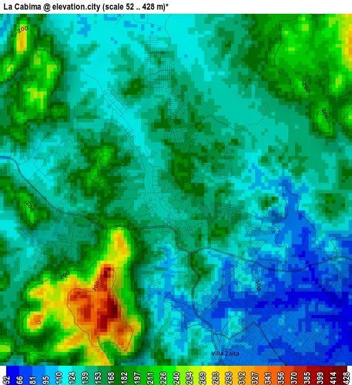
Below is the Elevation map of La Cabima, which displays elevation range with different colors. Scale of the first map is from 52 to 428 m (171 to 1404 ft) with average elevation of 153.6 meters (=504 ft) [note 1]
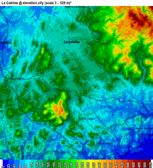
These maps also provides idea of topography and contour of this city, they are displayed at different zoom levels. More info about maps, scale and edge coordinates you can find below images.
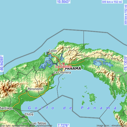
| \ | Map #1 | Map #2 | Topo.Map |
| Scale [m] | 52..428 m | 3..529 m | × |
| Scale [ft] | 171..1404 ft | 10..1736 ft | × |
| Average | 153.6 m = 504 ft | 141 m = 463 ft | × |
| Width | 9.65 km = 6 mi | 19.3 km = 12 mi | 308.7 km = 191.8 mi |
| Height | 9.65 km = 6 mi | 19.3 km = 12 mi | 308.8 km = 191.9 mi |
| ↑Max Latitude | 9.162037° | 9.205419° | 10.5043° |
| Latitude at center | 9.11865° | 9.11865° | 9.11865° |
| ↓Min Latitude | 9.075257° | 9.03186° | 7.7276° |
| ← Min Longitude | -79.580545° | -79.624491° | -80.94285° |
| Longitude center | -79.5366° | -79.5366° | -79.5366° |
| →Max Longitude | -79.492655° | -79.448709° | -78.13035° |
Nearby cities:
Cities around La Cabima sort by population:
• San Miguelito elevation 57 m
10.5 km,  136°
136°
• Juan Díaz 12 m
12.2 km,  128°
128°
• Las Cumbres 87 m
3.4 km,  164°
164°
• Chilibre 50 m
9.9 km,  291°
291°
• Río Abajo 15 m
12 km, 160°
• Alcalde Díaz 201 m
2.2 km,  274°
274°
• Villa Unida 83 m
12.4 km,  309°
309°
• San Vicente 120 m
6.7 km, 266°
• Gonzalillo 70 m
3.5 km,  147°
147°
• Calzada Larga 112 m
6.6 km,  335°
335°
• San Antonio 123 m
6.1 km,  348°
348°
• Caimitillo 121 m
4.1 km,  355°
355°
Multilingual:
 En español:
La Cabima elevación 156 m.
 En France:
La Cabima élévation 156 m.
 Auf Deutsch:
La Cabima höhe über dem Meeresspiegel ist 156 m.

Sources and notes:
- [note 1] Map square and city borders are not equal. Map elevation data is calculated only from area inside that square.
- [src 1] Elevation data from geonames database provided with same terms of usage.
- [src 2] The elevation map of La Cabima is generated using elevation data from NASA's 3 arcsec (90m) resolution SRTM data.
- [src 3] Base (background) map © OpenStreetMap contributors tiles are generated by Geofabrik and OpenTopoMap.
Copyright & License:
This La Cabima Elevation Map is licensed under CC BY-SA. You may reuse any part from this page, if you give a proper credit by linking to this URL:
 More info on terms of use page.