La Concepción elevation
La Concepción (Chiriquí), Panama elevation is 214 meters and La Concepción elevation in feet is 702 ft above sea level [src 1]. La Concepción is a seat of a second-order administrative division (feature code) with elevation that is 42 meters (138 ft) bigger than average city elevation in Panama.
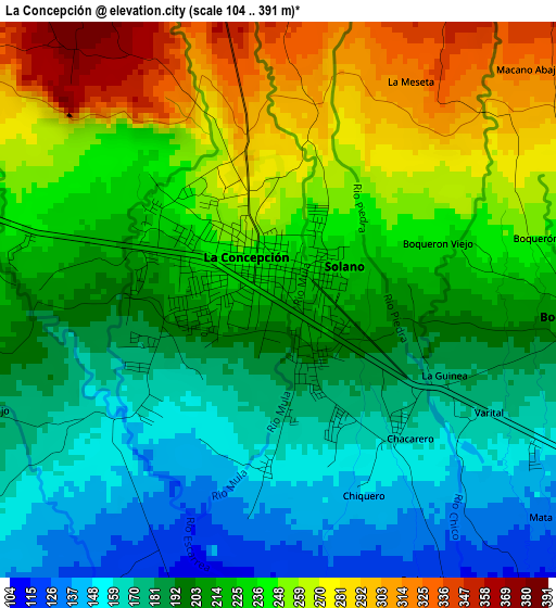
Below is the Elevation map of La Concepción, which displays elevation range with different colors. Scale of the first map is from 104 to 391 m (341 to 1283 ft) with average elevation of 217.8 meters (=715 ft) [note 1]
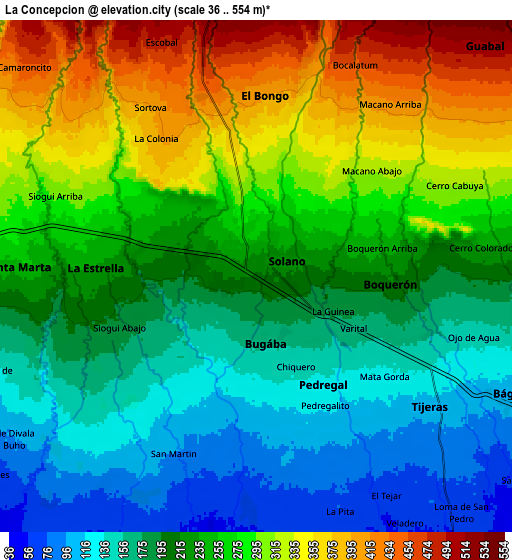
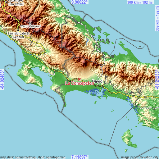
These maps also provides idea of topography and contour of this city, they are displayed at different zoom levels. More info about maps, scale and edge coordinates you can find below images.
| \ | Map #1 | Map #2 | Topo.Map |
| Scale [m] | 104..391 m | 36..554 m | × |
| Scale [ft] | 341..1283 ft | 118..1818 ft | × |
| Average | 217.8 m = 715 ft | 238.5 m = 782 ft | × |
| Width | 9.66 km = 6 mi | 19.33 km = 12 mi | 309.2 km = 192.1 mi |
| Height | 9.66 km = 6 mi | 19.33 km = 12 mi | 309.3 km = 192.2 mi |
| ↑Max Latitude | 8.555579° | 8.599033° | 9.90022° |
| Latitude at center | 8.51212° | 8.51212° | 8.51212° |
| ↓Min Latitude | 8.468656° | 8.425188° | 7.11897° |
| ← Min Longitude | -82.662525° | -82.706471° | -84.02483° |
| Longitude center | -82.61858° | -82.61858° | -82.61858° |
| →Max Longitude | -82.574635° | -82.530689° | -81.21233° |
Nearby cities:
Cities around La Concepción sort by population:
• Bugaba elevation 144 m
3.3 km,  182°
182°
• Sioguí Abajo 176 m
5.9 km,  241°
241°
• Santa Marta 246 m
8.8 km,  271°
271°
• Sortova 375 m
5.3 km,  316°
316°
• Boquerón 202 m
5.4 km,  98°
98°
• Tijeras 120 m
7.6 km,  122°
122°
• Sioguí Arriba 294 m
8 km,  291°
291°
• Bugabita Arriba 222 m
2.2 km,  297°
297°
• La Estrella 235 m
5.9 km, 273°
• El Tejar 55 m
10.4 km,  151°
151°
• Bongo Arriba 478 m
8.5 km,  357°
357°
• Chacarero 159 m
3.4 km,  139°
139°
Multilingual:
 En español:
La Concepción elevación 214 m.
 En France:
La Concepción élévation 214 m.
 Auf Deutsch:
La Concepción höhe über dem Meeresspiegel ist 214 m.

Sources and notes:
- [note 1] Map square and city borders are not equal. Map elevation data is calculated only from area inside that square.
- [src 1] Elevation data from geonames database provided with same terms of usage.
- [src 2] The elevation map of La Concepción is generated using elevation data from NASA's 3 arcsec (90m) resolution SRTM data.
- [src 3] Base (background) map © OpenStreetMap contributors tiles are generated by Geofabrik and OpenTopoMap.
Copyright & License:
This La Concepción Elevation Map is licensed under CC BY-SA. You may reuse any part from this page, if you give a proper credit by linking to this URL:
 More info on terms of use page.