La Mitra elevation
La Mitra (Panamá Oeste), Panama elevation is 91 meters and La Mitra elevation in feet is 299 ft above sea level [src 1]. La Mitra is a seat of a third-order administrative division (feature code) with elevation that is 81 meters (266 ft) smaller than average city elevation in Panama.
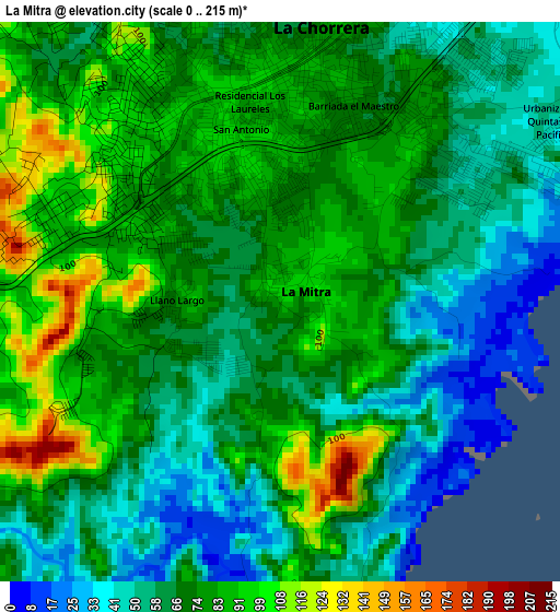
Below is the Elevation map of La Mitra, which displays elevation range with different colors. Scale of the first map is from 0 to 215 m (0 to 705 ft) with average elevation of 71.5 meters (=235 ft) [note 1]
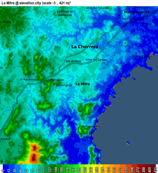
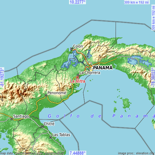
These maps also provides idea of topography and contour of this city, they are displayed at different zoom levels. More info about maps, scale and edge coordinates you can find below images.
| \ | Map #1 | Map #2 | Topo.Map |
| Scale [m] | 0..215 m | -3..421 m | × |
| Scale [ft] | 0..705 ft | -10..1381 ft | × |
| Average | 71.5 m = 235 ft | 76.2 m = 250 ft | × |
| Width | 9.66 km = 6 mi | 19.31 km = 12 mi | 309 km = 192 mi |
| Height | 9.66 km = 6 mi | 19.31 km = 12 mi | 309 km = 192 mi |
| ↑Max Latitude | 8.884331° | 8.927746° | 10.2277° |
| Latitude at center | 8.84091° | 8.84091° | 8.84091° |
| ↓Min Latitude | 8.797484° | 8.754053° | 7.44888° |
| ← Min Longitude | -79.830425° | -79.874371° | -81.19273° |
| Longitude center | -79.78648° | -79.78648° | -79.78648° |
| →Max Longitude | -79.742535° | -79.698589° | -78.38023° |
Nearby cities:
Cities around La Mitra sort by population:
• La Chorrera elevation 81 m
4.4 km,  4°
4°
• El Coco 93 m
3.8 km,  329°
329°
• Altos de San Francisco 84 m
2.3 km,  350°
350°
• La Pesa 90 m
4.2 km,  284°
284°
• Guadalupe 92 m
3.4 km,  296°
296°
• La Herradura 68 m
2.1 km,  293°
293°
• Puerto Caimito 10 m
8.6 km,  67°
67°
• Potrero Grande 80 m
6.3 km,  314°
314°
• Alto del Espino 73 m
6.5 km,  271°
271°
• El Espino 96 m
6.9 km, 267°
• Llano Largo 70 m
2.4 km,  253°
253°
• Playa Leona 28 m
6.5 km,  169°
169°
Multilingual:
 En español:
La Mitra elevación 91 m.
 En France:
La Mitra élévation 91 m.


Sources and notes:
- [note 1] Map square and city borders are not equal. Map elevation data is calculated only from area inside that square.
- [src 1] Elevation data from geonames database provided with same terms of usage.
- [src 2] The elevation map of La Mitra is generated using elevation data from NASA's 3 arcsec (90m) resolution SRTM data.
- [src 3] Base (background) map © OpenStreetMap contributors tiles are generated by Geofabrik and OpenTopoMap.
Copyright & License:
This La Mitra Elevation Map is licensed under CC BY-SA. You may reuse any part from this page, if you give a proper credit by linking to this URL:
 More info on terms of use page.