Lídice elevation
Lídice (Panamá), Panama elevation is 128 meters and Lídice elevation in feet is 420 ft above sea level [src 1]. Lídice is a populated place (feature code) with elevation that is 44 meters (144 ft) smaller than average city elevation in Panama.
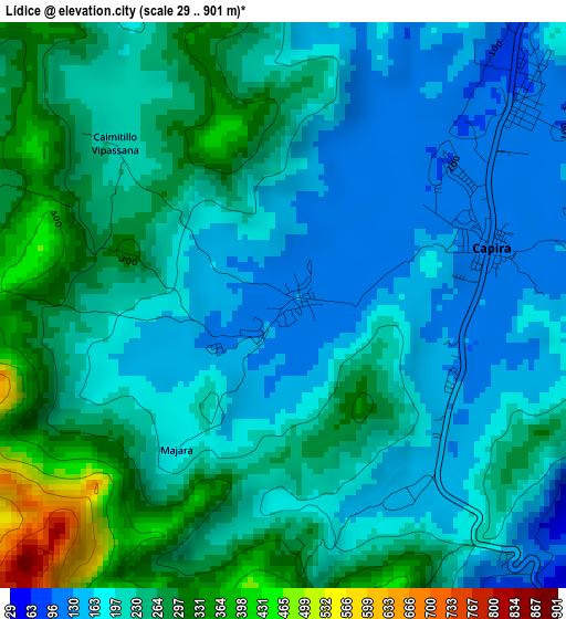
Below is the Elevation map of Lídice, which displays elevation range with different colors. Scale of the first map is from 29 to 901 m (95 to 2956 ft) with average elevation of 221 meters (=725 ft) [note 1]
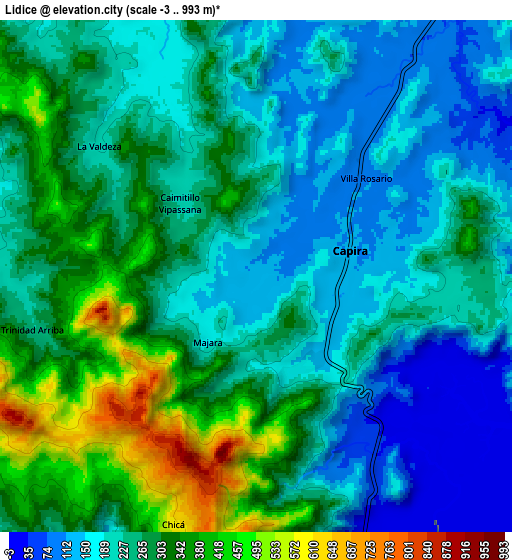
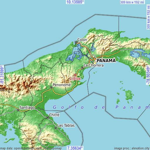
These maps also provides idea of topography and contour of this city, they are displayed at different zoom levels. More info about maps, scale and edge coordinates you can find below images.
| \ | Map #1 | Map #2 | Topo.Map |
| Scale [m] | 29..901 m | -3..993 m | × |
| Scale [ft] | 95..2956 ft | -10..3258 ft | × |
| Average | 221 m = 725 ft | 250.8 m = 823 ft | × |
| Width | 9.66 km = 6 mi | 19.32 km = 12 mi | 309.1 km = 192.1 mi |
| Height | 9.66 km = 6 mi | 19.32 km = 12 mi | 309.1 km = 192.1 mi |
| ↑Max Latitude | 8.792121° | 8.835548° | 10.13585° |
| Latitude at center | 8.74869° | 8.74869° | 8.74869° |
| ↓Min Latitude | 8.705253° | 8.661812° | 7.35634° |
| ← Min Longitude | -79.953685° | -79.997631° | -81.31599° |
| Longitude center | -79.90974° | -79.90974° | -79.90974° |
| →Max Longitude | -79.865795° | -79.821849° | -78.50349° |
Nearby cities:
Cities around Lídice sort by population:
• Villa Rosario elevation 109 m
4.7 km,  53°
53°
• Alto del Espino 73 m
12.6 km,  34°
34°
• Capira 114 m
3.4 km,  75°
75°
• El Espino 96 m
11.9 km, 33°
• El Espavé 18 m
10.4 km,  158°
158°
• Villa Carmen 92 m
7.1 km,  38°
38°
• Santa Rita 98 m
12.5 km,  15°
15°
• Cermeño 207 m
6.3 km,  97°
97°
• Caimito 178 m
8.1 km,  329°
329°
• El Cacao 204 m
11.4 km,  277°
277°
• Buenos Aires 232 m
13.7 km,  197°
197°
• Las Ollas Arriba 137 m
6.5 km,  356°
356°
Multilingual:
 En español:
Lídice elevación 128 m.
 En France:
Lídice élévation 128 m.


Sources and notes:
- [note 1] Map square and city borders are not equal. Map elevation data is calculated only from area inside that square.
- [src 1] Elevation data from geonames database provided with same terms of usage.
- [src 2] The elevation map of Lídice is generated using elevation data from NASA's 3 arcsec (90m) resolution SRTM data.
- [src 3] Base (background) map © OpenStreetMap contributors tiles are generated by Geofabrik and OpenTopoMap.
Copyright & License:
This Lídice Elevation Map is licensed under CC BY-SA. You may reuse any part from this page, if you give a proper credit by linking to this URL:
 More info on terms of use page.