Pedregal elevation
Pedregal (Panamá), Panama elevation is 34 meters and Pedregal elevation in feet is 112 ft above sea level [src 1]. Pedregal is a populated place (feature code) with elevation that is 138 meters (453 ft) smaller than average city elevation in Panama.
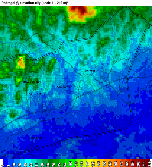
Below is the Elevation map of Pedregal, which displays elevation range with different colors. Scale of the first map is from 1 to 219 m (3 to 719 ft) with average elevation of 36.5 meters (=120 ft) [note 1]
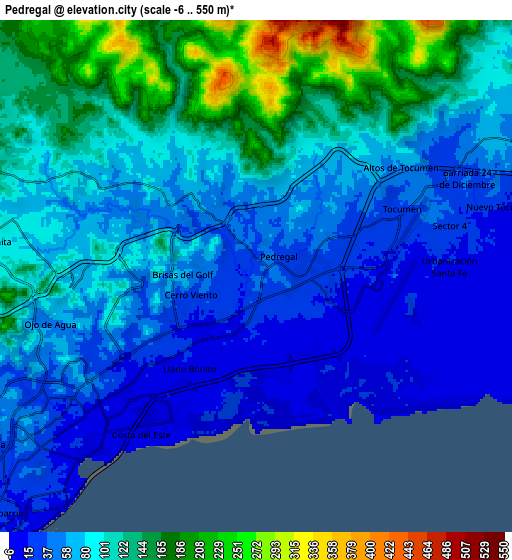
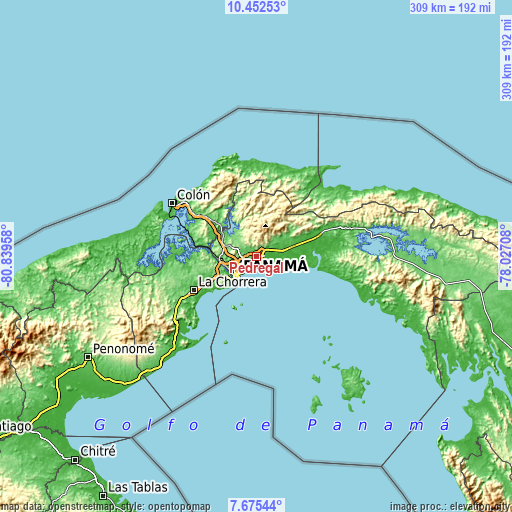
These maps also provides idea of topography and contour of this city, they are displayed at different zoom levels. More info about maps, scale and edge coordinates you can find below images.
| \ | Map #1 | Map #2 | Topo.Map |
| Scale [m] | 1..219 m | -6..550 m | × |
| Scale [ft] | 3..719 ft | -20..1804 ft | × |
| Average | 36.5 m = 120 ft | 85.6 m = 281 ft | × |
| Width | 9.65 km = 6 mi | 19.3 km = 12 mi | 308.8 km = 191.9 mi |
| Height | 9.65 km = 6 mi | 19.3 km = 12 mi | 308.8 km = 191.9 mi |
| ↑Max Latitude | 9.110064° | 9.153452° | 10.45253° |
| Latitude at center | 9.06667° | 9.06667° | 9.06667° |
| ↓Min Latitude | 9.023271° | 8.979867° | 7.67544° |
| ← Min Longitude | -79.477275° | -79.521221° | -80.83958° |
| Longitude center | -79.43333° | -79.43333° | -79.43333° |
| →Max Longitude | -79.389385° | -79.345439° | -78.02708° |
Nearby cities:
Cities around Pedregal sort by population:
• San Miguelito elevation 57 m
4.5 km,  246°
246°
• Juan Díaz 12 m
2.6 km,  224°
224°
• Las Cumbres 87 m
10.7 km,  283°
283°
• Tocumen 35 m
6.1 km,  65°
65°
• Parque Lefevre 8 m
7.8 km, 224°
• Río Abajo 15 m
9.2 km,  232°
232°
• Nuevo Belén 19 m
4.4 km, 71°
• Gonzalillo 70 m
9.8 km,  286°
286°
• Vista Hermosa 45 m
9.4 km,  57°
57°
• Cabra Número Uno 44 m
11.6 km, 66°
• Cerro Azul 559 m
10.2 km,  7°
7°
• La Colorada 64 m
4.4 km,  25°
25°
Multilingual:
 En español:
Pedregal elevación 34 m.
 En France:
Pedregal élévation 34 m.


Sources and notes:
- [note 1] Map square and city borders are not equal. Map elevation data is calculated only from area inside that square.
- [src 1] Elevation data from geonames database provided with same terms of usage.
- [src 2] The elevation map of Pedregal is generated using elevation data from NASA's 3 arcsec (90m) resolution SRTM data.
- [src 3] Base (background) map © OpenStreetMap contributors tiles are generated by Geofabrik and OpenTopoMap.
Copyright & License:
This Pedregal Elevation Map is licensed under CC BY-SA. You may reuse any part from this page, if you give a proper credit by linking to this URL:
 More info on terms of use page.