Púcuro elevation
Púcuro (Darién), Panama elevation is 60 meters and Púcuro elevation in feet is 197 ft above sea level [src 1]. Púcuro is a seat of a third-order administrative division (feature code) with elevation that is 112 meters (367 ft) smaller than average city elevation in Panama.
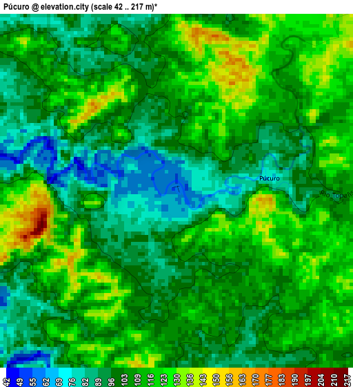
Below is the Elevation map of Púcuro, which displays elevation range with different colors. Scale of the first map is from 42 to 217 m (138 to 712 ft) with average elevation of 105.3 meters (=345 ft) [note 1]
These maps also provides idea of topography and contour of this city, they are displayed at different zoom levels. More info about maps, scale and edge coordinates you can find below images.
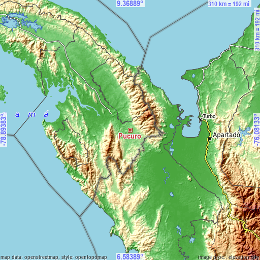
| \ | Map #1 | Topo.Map |
| Scale [m] | 42..217 m | × |
| Scale [ft] | 138..712 ft | × |
| Average | 105.3 m = 345 ft | × |
| Width | 9.68 km = 6 mi | 309.7 km = 192.4 mi |
| Height | 9.68 km = 6 mi | 309.7 km = 192.4 mi |
| ↑Max Latitude | 8.022278° | 9.36889° |
| Latitude at center | 7.97876° | 7.97876° |
| ↓Min Latitude | 7.935238° | 6.58389° |
| ← Min Longitude | -77.531525° | -78.89383° |
| Longitude center | -77.48758° | -77.48758° |
| →Max Longitude | -77.443635° | -76.08133° |
Nearby cities:
Cities around Púcuro sort by population:
• Unión Chocó elevation 61 m
12.8 km,  335°
335°
• Yaviza 10 m
30.1 km,  311°
311°
• Boca de Cupé 33 m
12.6 km,  296°
296°
• Corozal 25 m
27.5 km,  334°
334°
• Camogantí 9 m
44.5 km,  279°
279°
• Yape 19 m
18 km,  317°
317°
• Chepigana 76 m
70.9 km, 298°
• Jingurudó 63 m
65.8 km,  260°
260°
• Lajas Blancas 20 m
60.2 km, 323°
• Tucutí 74 m
50.8 km, 263°
• Pinogana 17 m
26.7 km, 304°
• Paya 97 m
13.8 km,  128°
128°
Multilingual:
 En español:
Púcuro elevación 60 m.
 En France:
Púcuro élévation 60 m.


Sources and notes:
- [note 1] Map square and city borders are not equal. Map elevation data is calculated only from area inside that square.
- [src 1] Elevation data from geonames database provided with same terms of usage.
- [src 2] The elevation map of Púcuro is generated using elevation data from NASA's 3 arcsec (90m) resolution SRTM data.
- [src 3] Base (background) map © OpenStreetMap contributors tiles are generated by Geofabrik and OpenTopoMap.
Copyright & License:
This Púcuro Elevation Map is licensed under CC BY-SA. You may reuse any part from this page, if you give a proper credit by linking to this URL:
 More info on terms of use page.