Salud elevation
Salud (Colón), Panama elevation is 6 meters and Salud elevation in feet is 20 ft above sea level [src 1]. Salud is a seat of a third-order administrative division (feature code) with elevation that is 166 meters (545 ft) smaller than average city elevation in Panama.
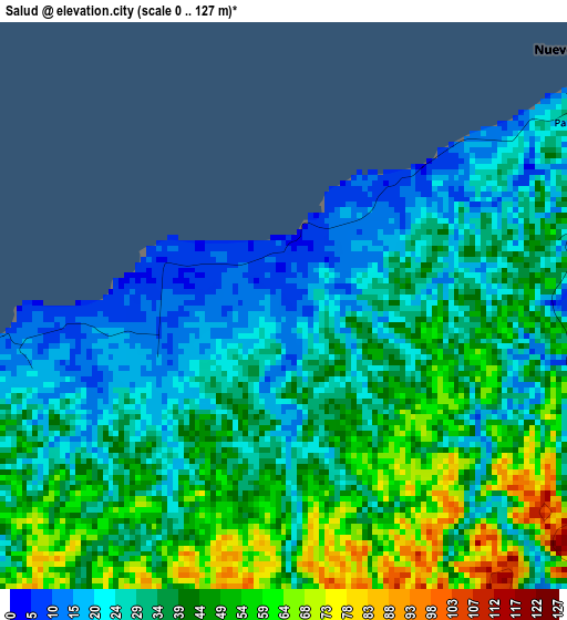
Below is the Elevation map of Salud, which displays elevation range with different colors. Scale of the first map is from 0 to 127 m (0 to 417 ft) with average elevation of 37 meters (=121 ft) [note 1]
These maps also provides idea of topography and contour of this city, they are displayed at different zoom levels. More info about maps, scale and edge coordinates you can find below images.
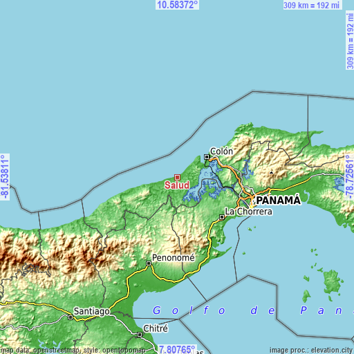
| \ | Map #1 | Topo.Map |
| Scale [m] | 0..127 m | × |
| Scale [ft] | 0..417 ft | × |
| Average | 37 m = 121 ft | × |
| Width | 9.65 km = 6 mi | 308.7 km = 191.8 mi |
| Height | 9.65 km = 6 mi | 308.7 km = 191.8 mi |
| ↑Max Latitude | 9.241788° | 10.58372° |
| Latitude at center | 9.19841° | 9.19841° |
| ↓Min Latitude | 9.155027° | 7.80765° |
| ← Min Longitude | -80.175805° | -81.53811° |
| Longitude center | -80.13186° | -80.13186° |
| →Max Longitude | -80.087915° | -78.72561° |
Nearby cities:
Cities around Salud sort by population:
• Puerto Escondido elevation 23 m
4.8 km,  96°
96°
• Escobal 48 m
19.4 km,  108°
108°
• Palmas Bellas 34 m
6.1 km,  57°
57°
• Nuevo Chagres 24 m
7.1 km,  49°
49°
• El Guabo 72 m
14.4 km,  158°
158°
• Cirí de Los Sotos 84 m
25.5 km,  170°
170°
• Miguel de La Borda 11 m
19.5 km,  252°
252°
• Cuipo 28 m
17 km,  147°
147°
• La Encantada 6 m
14 km,  207°
207°
• Gobea 42 m
13.7 km, 251°
• Achiote 17 m
13.1 km,  83°
83°
• Boca de Río Indio 4 m
6.7 km,  255°
255°
Multilingual:
 En español:
Salud elevación 6 m.
 En France:
Salud élévation 6 m.


Sources and notes:
- [note 1] Map square and city borders are not equal. Map elevation data is calculated only from area inside that square.
- [src 1] Elevation data from geonames database provided with same terms of usage.
- [src 2] The elevation map of Salud is generated using elevation data from NASA's 3 arcsec (90m) resolution SRTM data.
- [src 3] Base (background) map © OpenStreetMap contributors tiles are generated by Geofabrik and OpenTopoMap.
Copyright & License:
This Salud Elevation Map is licensed under CC BY-SA. You may reuse any part from this page, if you give a proper credit by linking to this URL:
 More info on terms of use page.