Vista Alegre elevation
Vista Alegre (Panamá Oeste), Panama elevation is 33 meters and Vista Alegre elevation in feet is 108 ft above sea level [src 1]. Vista Alegre is a seat of a third-order administrative division (feature code) with elevation that is 139 meters (456 ft) smaller than average city elevation in Panama.
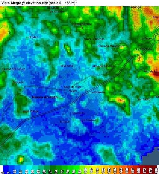
Below is the Elevation map of Vista Alegre, which displays elevation range with different colors. Scale of the first map is from 0 to 186 m (0 to 610 ft) with average elevation of 42.2 meters (=138 ft) [note 1]
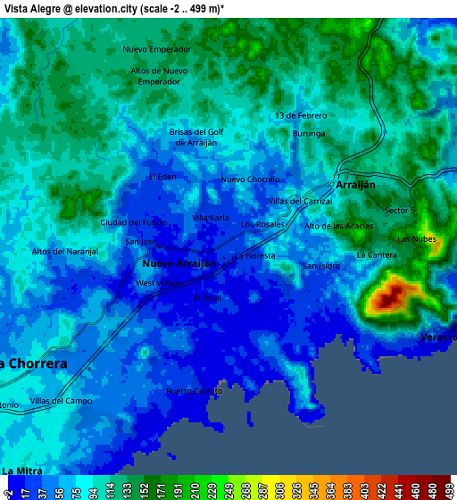
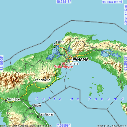
These maps also provides idea of topography and contour of this city, they are displayed at different zoom levels. More info about maps, scale and edge coordinates you can find below images.
| \ | Map #1 | Map #2 | Topo.Map |
| Scale [m] | 0..186 m | -2..499 m | × |
| Scale [ft] | 0..610 ft | -7..1637 ft | × |
| Average | 42.2 m = 138 ft | 85.4 m = 280 ft | × |
| Width | 9.65 km = 6 mi | 19.31 km = 12 mi | 308.9 km = 191.9 mi |
| Height | 9.65 km = 6 mi | 19.31 km = 12 mi | 308.9 km = 191.9 mi |
| ↑Max Latitude | 8.97113° | 9.014535° | 10.31416° |
| Latitude at center | 8.92772° | 8.92772° | 8.92772° |
| ↓Min Latitude | 8.884305° | 8.840884° | 7.53599° |
| ← Min Longitude | -79.746745° | -79.790691° | -81.10905° |
| Longitude center | -79.7028° | -79.7028° | -79.7028° |
| →Max Longitude | -79.658855° | -79.614909° | -78.29655° |
Nearby cities:
Cities around Vista Alegre sort by population:
• Arraiján elevation 98 m
5.4 km,  60°
60°
• La Chorrera 81 m
10.3 km,  239°
239°
• Veracruz 12 m
9.4 km,  116°
116°
• Nuevo Arraiján 16 m
1.9 km,  259°
259°
• Altos de San Francisco 84 m
12.1 km,  232°
232°
• Puerto Caimito 10 m
6.5 km,  191°
191°
• San José 20 m
3.4 km,  280°
280°
• Nuevo Emperador 125 m
8.9 km,  339°
339°
• San Vicente de Bique 20 m
3.7 km, 119°
• Hato Montaña 43 m
4.1 km, 256°
• Howard 18 m
12.4 km,  83°
83°
• Río Congo 130 m
7.7 km,  304°
304°
Multilingual:
 En español:
Vista Alegre elevación 33 m.
 En France:
Vista Alegre élévation 33 m.
 Auf Deutsch:
Vista Alegre höhe über dem Meeresspiegel ist 33 m.

Sources and notes:
- [note 1] Map square and city borders are not equal. Map elevation data is calculated only from area inside that square.
- [src 1] Elevation data from geonames database provided with same terms of usage.
- [src 2] The elevation map of Vista Alegre is generated using elevation data from NASA's 3 arcsec (90m) resolution SRTM data.
- [src 3] Base (background) map © OpenStreetMap contributors tiles are generated by Geofabrik and OpenTopoMap.
Copyright & License:
This Vista Alegre Elevation Map is licensed under CC BY-SA. You may reuse any part from this page, if you give a proper credit by linking to this URL:
 More info on terms of use page.