Askøy elevation
Askøy (Hordaland), Norway elevation is 1 meters and Askøy elevation in feet is 3 ft above sea level [src 1]. Askøy is a populated place (feature code) with elevation that is 100 meters (328 ft) smaller than average city elevation in Norway.
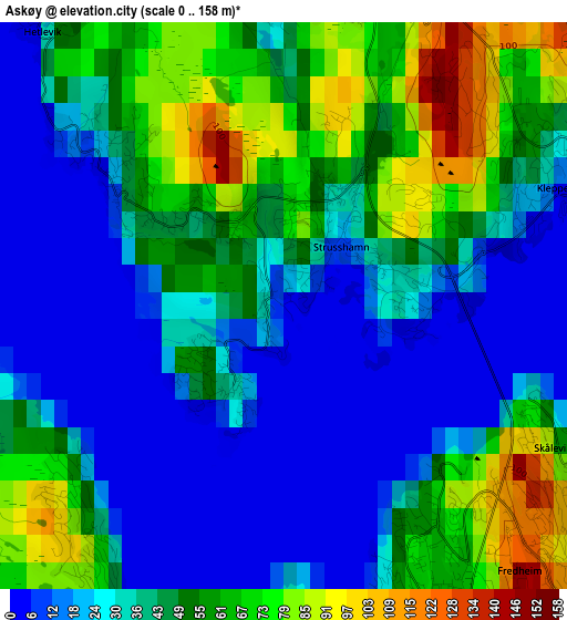
Below is the Elevation map of Askøy, which displays elevation range with different colors. Scale of the first map is from 0 to 158 m (0 to 518 ft) with average elevation of 40.3 meters (=132 ft) [note 1]
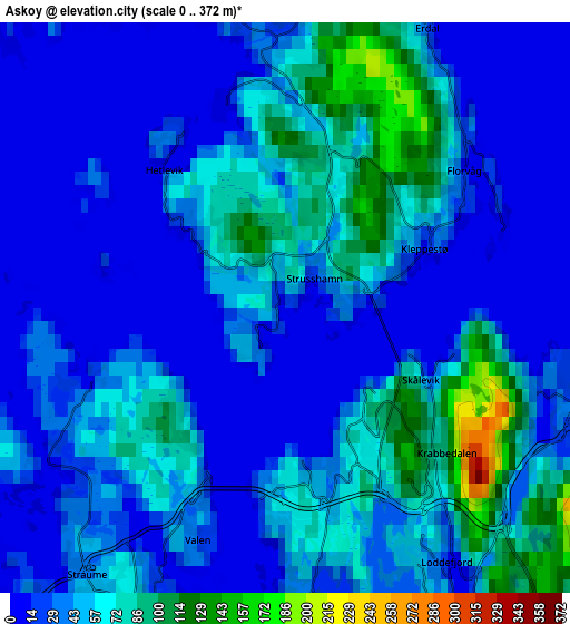
These maps also provides idea of topography and contour of this city, they are displayed at different zoom levels. More info about maps, scale and edge coordinates you can find below images.
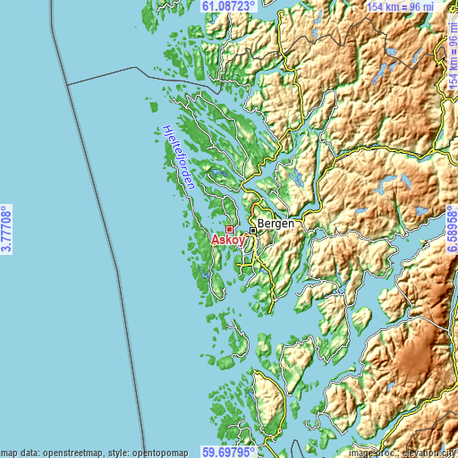
| \ | Map #1 | Map #2 | Topo.Map |
| Scale [m] | 0..158 m | 0..372 m | × |
| Scale [ft] | 0..518 ft | 0..1220 ft | × |
| Average | 40.3 m = 132 ft | 41.1 m = 135 ft | × |
| Width | 4.83 km = 3 mi | 9.65 km = 6 mi | 154.5 km = 96 mi |
| Height | 4.83 km = 3 mi | 9.65 km = 6 mi | 154.5 km = 96 mi |
| ↑Max Latitude | 60.421699° | 60.443384° | 61.08723° |
| Latitude at center | 60.4° | 60.4° | 60.4° |
| ↓Min Latitude | 60.378286° | 60.356558° | 59.69795° |
| ← Min Longitude | 5.139385° | 5.095439° | 3.77708° |
| Longitude center | 5.18333° | 5.18333° | 5.18333° |
| →Max Longitude | 5.227275° | 5.271221° | 6.58958° |
Nearby cities:
Cities around Askøy sort by population:
• Bergen elevation 20 m
7.8 km,  95°
95°
• Ytrebygda 60 m
11.9 km,  152°
152°
• Indre Arna 234 m
15.9 km,  82°
82°
• Ytre Arna 3 m
15.3 km,  63°
63°
• Hylkje 15 m
15.4 km,  37°
37°
• Espeland 120 m
15.6 km, 97°
• Frekhaug 1 m
13 km,  14°
14°
• Ågotnes 20 m
9 km,  272°
272°
• Sandsli 40 m
12.1 km, 152°
• Knappskog 1 m
7.4 km,  251°
251°
• Straume 40 m
5.5 km,  218°
218°
• Kleppestø 3 m
2.6 km,  68°
68°
Multilingual:
 En español:
Askøy elevación 1 m.
 En France:
Askøy élévation 1 m.


Sources and notes:
- [note 1] Map square and city borders are not equal. Map elevation data is calculated only from area inside that square.
- [src 1] Elevation data from geonames database provided with same terms of usage.
- [src 2] The elevation map of Askøy is generated using GMTED2010 database with 7.5 arcsec (225m) resolution.
- [src 3] Base (background) map © OpenStreetMap contributors tiles are generated by Geofabrik and OpenTopoMap.
Copyright & License:
This Askøy Elevation Map is licensed under CC BY-SA. You may reuse any part from this page, if you give a proper credit by linking to this URL:
 More info on terms of use page.