Ålen elevation
Ålen (Trøndelag, Holtålen), Norway elevation is 460 meters and Ålen elevation in feet is 1509 ft above sea level [src 1]. Ålen is a seat of a second-order administrative division (feature code) with elevation that is 359 meters (1178 ft) bigger than average city elevation in Norway.
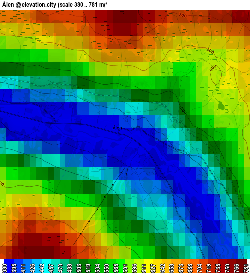
Below is the Elevation map of Ålen, which displays elevation range with different colors. Scale of the first map is from 380 to 781 m (1247 to 2562 ft) with average elevation of 538.8 meters (=1768 ft) [note 1]
These maps also provides idea of topography and contour of this city, they are displayed at different zoom levels. More info about maps, scale and edge coordinates you can find below images.
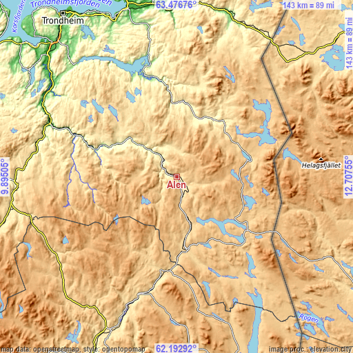
| \ | Map #1 | Topo.Map |
| Scale [m] | 380..781 m | × |
| Scale [ft] | 1247..2562 ft | × |
| Average | 538.8 m = 1768 ft | × |
| Width | 4.46 km = 2.8 mi | 142.7 km = 88.7 mi |
| Height | 4.46 km = 2.8 mi | 142.7 km = 88.7 mi |
| ↑Max Latitude | 62.861902° | 63.47676° |
| Latitude at center | 62.84185° | 62.84185° |
| ↓Min Latitude | 62.821784° | 62.19292° |
| ← Min Longitude | 11.257355° | 9.89505° |
| Longitude center | 11.3013° | 11.3013° |
| →Max Longitude | 11.345245° | 12.70755° |
Nearby cities:
Cities around Ålen sort by population:
• Hommelvik elevation 12 m
68.2 km,  338°
338°
• Røros 640 m
30 km,  171°
171°
• Tynset 483 m
68.3 km,  202°
202°
• Lundamo 47 m
61.8 km,  303°
303°
• Meråker 206 m
67.4 km,  19°
19°
• Berkåk 470 m
65.5 km,  268°
268°
• Tolga 560 m
50.6 km, 197°
• Os 613 m
38.6 km,  185°
185°
• Klæbu 140 m
65.3 km,  320°
320°
• Støren 82 m
55.9 km,  293°
293°
• Mebonden 215 m
45.3 km, 342°
• Aas 440 m
29.1 km,  37°
37°
Multilingual:
 En español:
Ålen elevación 460 m.
 En France:
Ålen élévation 460 m.


Sources and notes:
- [note 1] Map square and city borders are not equal. Map elevation data is calculated only from area inside that square.
- [src 1] Elevation data from geonames database provided with same terms of usage.
- [src 2] The elevation map of Ålen is generated using GMTED2010 database with 7.5 arcsec (225m) resolution.
- [src 3] Base (background) map © OpenStreetMap contributors tiles are generated by Geofabrik and OpenTopoMap.
Copyright & License:
This Ålen Elevation Map is licensed under CC BY-SA. You may reuse any part from this page, if you give a proper credit by linking to this URL:
 More info on terms of use page.