Kongsvinger elevation
Kongsvinger (Hedmark), Norway elevation is 157 meters and Kongsvinger elevation in feet is 515 ft above sea level [src 1]. Kongsvinger is a seat of a second-order administrative division (feature code) with elevation that is 56 meters (184 ft) bigger than average city elevation in Norway.
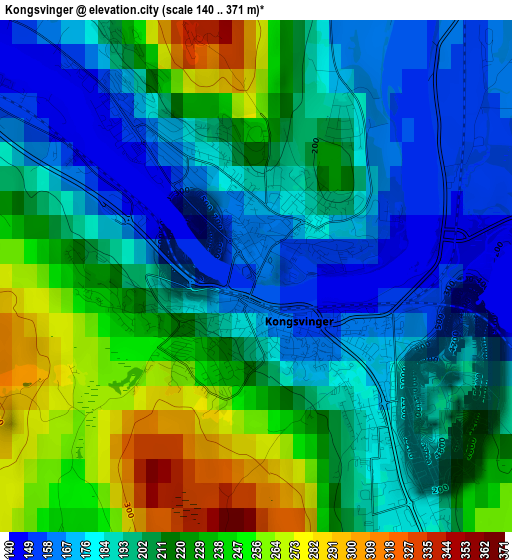
Below is the Elevation map of Kongsvinger, which displays elevation range with different colors. Scale of the first map is from 140 to 371 m (459 to 1217 ft) with average elevation of 206.1 meters (=676 ft) [note 1]
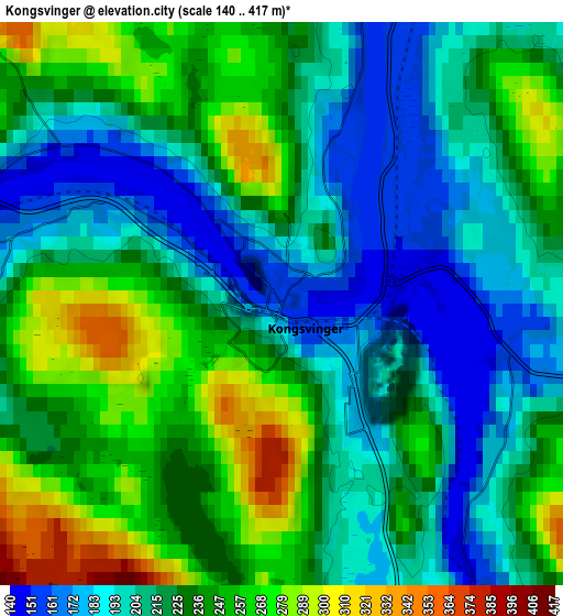
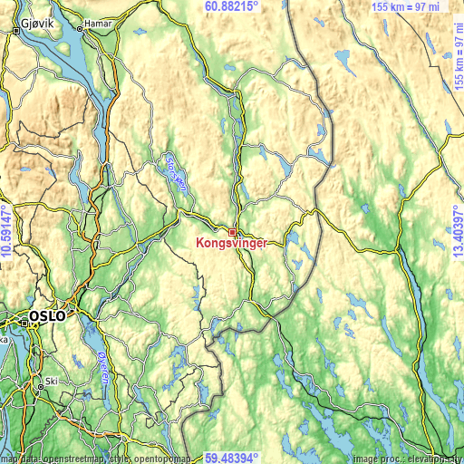
These maps also provides idea of topography and contour of this city, they are displayed at different zoom levels. More info about maps, scale and edge coordinates you can find below images.
| \ | Map #1 | Map #2 | Topo.Map |
| Scale [m] | 140..371 m | 140..417 m | × |
| Scale [ft] | 459..1217 ft | 459..1368 ft | × |
| Average | 206.1 m = 676 ft | 223.9 m = 735 ft | × |
| Width | 4.86 km = 3 mi | 9.72 km = 6 mi | 155.5 km = 96.6 mi |
| Height | 4.86 km = 3 mi | 9.72 km = 6 mi | 155.4 km = 96.6 mi |
| ↑Max Latitude | 60.212329° | 60.234153° | 60.88215° |
| Latitude at center | 60.19049° | 60.19049° | 60.19049° |
| ↓Min Latitude | 60.168637° | 60.146769° | 59.48394° |
| ← Min Longitude | 11.953775° | 11.909829° | 10.59147° |
| Longitude center | 11.99772° | 11.99772° | 11.99772° |
| →Max Longitude | 12.041665° | 12.085611° | 13.40397° |
Nearby cities:
Cities around Kongsvinger sort by population:
• Årnes elevation 140 m
30.2 km,  255°
255°
• Auli 161 m
39.3 km,  243°
243°
• Bjørkelangen 137 m
41.8 km,  215°
215°
• Aursmoen 180 m
42.5 km,  226°
226°
• Skarnes 140 m
18.7 km,  292°
292°
• Spetalen 230 m
5.5 km, 261°
• Skotterud 144 m
24.2 km,  162°
162°
• Kirkenær 157 m
29.9 km,  6°
6°
• Neskollen 174 m
37.2 km, 258°
• Fjellfoten 182 m
31.2 km,  248°
248°
• Sand 160 m
33.7 km,  311°
311°
• Eidsvoll 160 m
43.5 km, 291°
Multilingual:
 En español:
Kongsvinger elevación 157 m.
 En France:
Kongsvinger élévation 157 m.
 Auf Deutsch:
Kongsvinger höhe über dem Meeresspiegel ist 157 m.

Sources and notes:
- [note 1] Map square and city borders are not equal. Map elevation data is calculated only from area inside that square.
- [src 1] Elevation data from geonames database provided with same terms of usage.
- [src 2] The elevation map of Kongsvinger is generated using GMTED2010 database with 7.5 arcsec (225m) resolution.
- [src 3] Base (background) map © OpenStreetMap contributors tiles are generated by Geofabrik and OpenTopoMap.
Copyright & License:
This Kongsvinger Elevation Map is licensed under CC BY-SA. You may reuse any part from this page, if you give a proper credit by linking to this URL:
 More info on terms of use page.