Nærbø elevation
Nærbø (Rogaland, Hå), Norway elevation is 35 meters and Nærbø elevation in feet is 115 ft above sea level [src 1]. Nærbø is a populated place (feature code) with elevation that is 66 meters (217 ft) smaller than average city elevation in Norway.
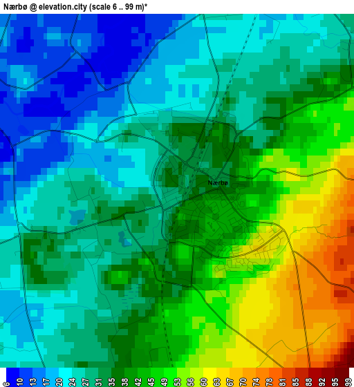
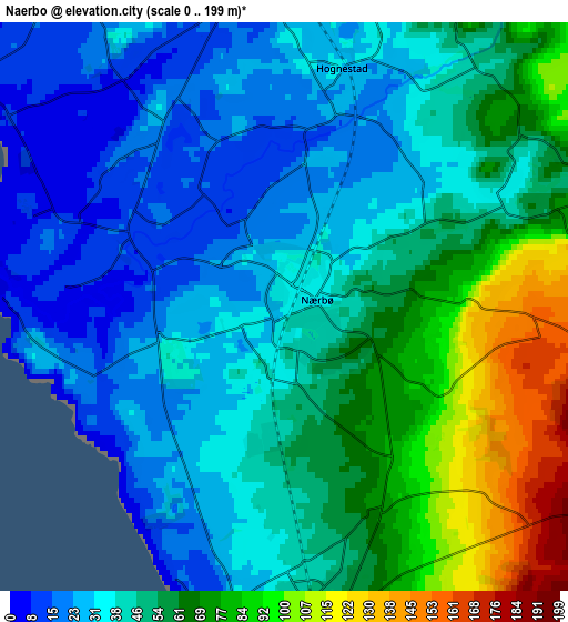
Below is the Elevation map of Nærbø, which displays elevation range with different colors. Scale of the first map is from 6 to 99 m (20 to 325 ft) with average elevation of 35.2 meters (=115 ft) [note 1]
These maps also provides idea of topography and contour of this city, they are displayed at different zoom levels. More info about maps, scale and edge coordinates you can find below images.
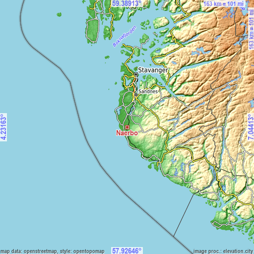
| \ | Map #1 | Map #2 | Topo.Map |
| Scale [m] | 6..99 m | 0..199 m | × |
| Scale [ft] | 20..325 ft | 0..653 ft | × |
| Average | 35.2 m = 115 ft | 48.7 m = 160 ft | × |
| Width | 5.08 km = 3.2 mi | 10.16 km = 6.3 mi | 162.6 km = 101 mi |
| Height | 5.08 km = 3.2 mi | 10.16 km = 6.3 mi | 162.6 km = 101 mi |
| ↑Max Latitude | 58.688306° | 58.711136° | 59.38913° |
| Latitude at center | 58.66546° | 58.66546° | 58.66546° |
| ↓Min Latitude | 58.642599° | 58.619724° | 57.92646° |
| ← Min Longitude | 5.593935° | 5.549989° | 4.23163° |
| Longitude center | 5.63788° | 5.63788° | 5.63788° |
| →Max Longitude | 5.681825° | 5.725771° | 7.04413° |
Nearby cities:
Cities around Nærbø sort by population:
• Sandnes elevation 8 m
21.5 km,  15°
15°
• Egersund 4 m
31.7 km,  138°
138°
• Bryne 33 m
7.8 km,  4°
4°
• Tananger 19 m
30.3 km,  353°
353°
• Hommersåk 19 m
31.4 km, 23°
• Varhaug 57 m
5.4 km,  168°
168°
• Lyefjell 118 m
9.6 km,  36°
36°
• Vigrestad 30 m
10.8 km, 166°
• Vikeså 97 m
26.4 km,  96°
96°
• Sola 11 m
24.8 km, 1°
• Ålgård 116 m
16.6 km,  48°
48°
• Kleppe 44 m
12.1 km,  357°
357°
Multilingual:
 En español:
Nærbø elevación 35 m.
 En France:
Nærbø élévation 35 m.


Sources and notes:
- [note 1] Map square and city borders are not equal. Map elevation data is calculated only from area inside that square.
- [src 1] Elevation data from geonames database provided with same terms of usage.
- [src 2] The elevation map of Nærbø is generated using elevation data from NASA's 3 arcsec (90m) resolution SRTM data.
- [src 3] Base (background) map © OpenStreetMap contributors tiles are generated by Geofabrik and OpenTopoMap.
Copyright & License:
This Nærbø Elevation Map is licensed under CC BY-SA. You may reuse any part from this page, if you give a proper credit by linking to this URL:
 More info on terms of use page.