Odda elevation
Odda (Hordaland), Norway elevation is 53 meters and Odda elevation in feet is 174 ft above sea level [src 1]. Odda is a seat of a second-order administrative division (feature code) with elevation that is 48 meters (157 ft) smaller than average city elevation in Norway.
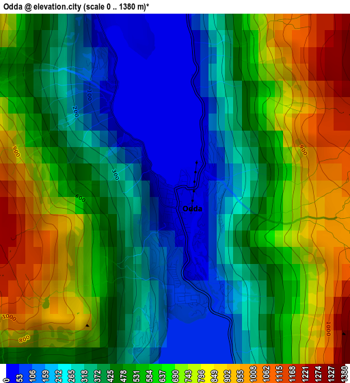
Below is the Elevation map of Odda, which displays elevation range with different colors. Scale of the first map is from 0 to 1380 m (0 to 4528 ft) with average elevation of 499.8 meters (=1640 ft) [note 1]
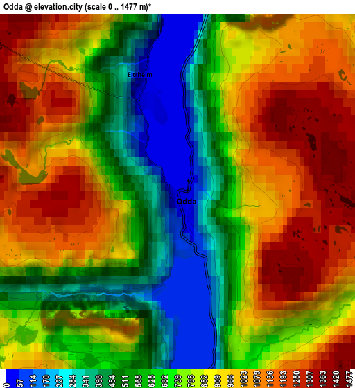
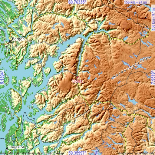
These maps also provides idea of topography and contour of this city, they are displayed at different zoom levels. More info about maps, scale and edge coordinates you can find below images.
| \ | Map #1 | Map #2 | Topo.Map |
| Scale [m] | 0..1380 m | 0..1477 m | × |
| Scale [ft] | 0..4528 ft | 0..4846 ft | × |
| Average | 499.8 m = 1640 ft | 798.2 m = 2619 ft | × |
| Width | 4.88 km = 3 mi | 9.75 km = 6.1 mi | 156 km = 96.9 mi |
| Height | 4.88 km = 3 mi | 9.75 km = 6.1 mi | 156 km = 96.9 mi |
| ↑Max Latitude | 60.091039° | 60.112944° | 60.76335° |
| Latitude at center | 60.06912° | 60.06912° | 60.06912° |
| ↓Min Latitude | 60.047186° | 60.025237° | 59.35997° |
| ← Min Longitude | 6.501705° | 6.457759° | 5.1394° |
| Longitude center | 6.54565° | 6.54565° | 6.54565° |
| →Max Longitude | 6.589595° | 6.633541° | 7.9519° |
Nearby cities:
Cities around Odda sort by population:
• Sauda elevation 11 m
47.7 km,  192°
192°
• Norheimsund 3 m
40.2 km,  326°
326°
• Øystese 5 m
40.5 km, 331°
• Etne 8 m
56.3 km,  217°
217°
• Rosendal 10 m
31.1 km,  252°
252°
• Eidfjord 25 m
53 km,  33°
33°
• Granvin 200 m
51.5 km,  10°
10°
• Kinsarvik 70 m
35.4 km,  15°
15°
• Eikelandsosen 53 m
48.3 km,  293°
293°
• Uggdal 150 m
56.9 km,  262°
262°
• Tysse 293 m
55.1 km,  307°
307°
• Jondal 48 m
28.1 km,  324°
324°
Multilingual:
 En español:
Odda elevación 53 m.
 En France:
Odda élévation 53 m.


Sources and notes:
- [note 1] Map square and city borders are not equal. Map elevation data is calculated only from area inside that square.
- [src 1] Elevation data from geonames database provided with same terms of usage.
- [src 2] The elevation map of Odda is generated using GMTED2010 database with 7.5 arcsec (225m) resolution.
- [src 3] Base (background) map © OpenStreetMap contributors tiles are generated by Geofabrik and OpenTopoMap.
Copyright & License:
This Odda Elevation Map is licensed under CC BY-SA. You may reuse any part from this page, if you give a proper credit by linking to this URL:
 More info on terms of use page.