Oslo elevation
Oslo, Norway elevation is 26 meters and Oslo elevation in feet is 85 ft above sea level [src 1]. Oslo is a capital of a political entity (feature code) with elevation that is 75 meters (246 ft) smaller than average city elevation in Norway.
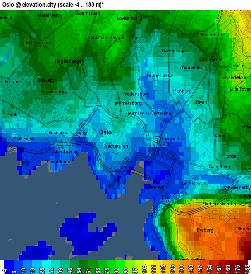
Below is the Elevation map of Oslo, which displays elevation range with different colors. Scale of the first map is from -4 to 183 m (-13 to 600 ft) with average elevation of 49.5 meters (=162 ft) [note 1]
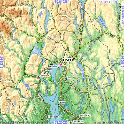
These maps also provides idea of topography and contour of this city, they are displayed at different zoom levels. More info about maps, scale and edge coordinates you can find below images.
| \ | Map #1 | Map #2 | Topo.Map |
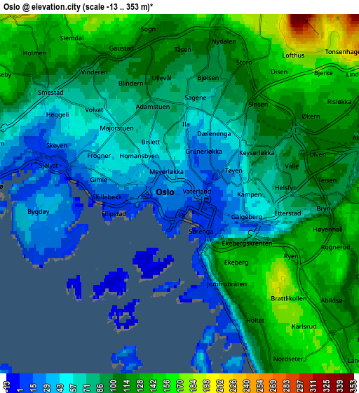
| Scale [m] | -4..183 m | -13..353 m | × |
| Scale [ft] | -13..600 ft | -43..1158 ft | × |
| Average | 49.5 m = 162 ft | 91.2 m = 299 ft | × |
| Width | 4.9 km = 3 mi | 9.8 km = 6.1 mi | 156.8 km = 97.4 mi |
| Height | 4.9 km = 3 mi | 9.8 km = 6.1 mi | 156.8 km = 97.4 mi |
| ↑Max Latitude | 59.934753° | 59.956762° | 60.61026° |
| Latitude at center | 59.91273° | 59.91273° | 59.91273° |
| ↓Min Latitude | 59.890692° | 59.86864° | 59.20023° |
| ← Min Longitude | 10.702145° | 10.658199° | 9.33984° |
| Longitude center | 10.74609° | 10.74609° | 10.74609° |
| →Max Longitude | 10.790035° | 10.833981° | 12.15234° |
Nearby cities:
Cities around Oslo sort by population:
• Lillestrøm elevation 116 m
17.6 km,  74°
74°
• Nesoddtangen 60 m
7.3 km,  219°
219°
• Rotnes 190 m
17.3 km,  21°
21°
• Skui 60 m
16.7 km,  275°
275°
• Lysaker 50 m
6.2 km,  267°
267°
• Billingstad 45 m
15.3 km,  254°
254°
• Blakstad 25 m
18.9 km,  236°
236°
• Sjølyststranda 13 m
3.8 km, 284°
• Fjerdingby 204 m
17.9 km,  85°
85°
• Sandvika 13 m
12.4 km,  258°
258°
• Kolbotn 112 m
11.8 km,  164°
164°
• Kjenn 181 m
11.7 km,  80°
80°
Multilingual:
 En español:
Oslo elevación 26 m.
 En France:
Oslo élévation 26 m.


Sources and notes:
- [note 1] Map square and city borders are not equal. Map elevation data is calculated only from area inside that square.
- [src 1] Elevation data from geonames database provided with same terms of usage.
- [src 2] The elevation map of Oslo is generated using elevation data from NASA's 3 arcsec (90m) resolution SRTM data.
- [src 3] Base (background) map © OpenStreetMap contributors tiles are generated by Geofabrik and OpenTopoMap.
Copyright & License:
This Oslo Elevation Map is licensed under CC BY-SA. You may reuse any part from this page, if you give a proper credit by linking to this URL:
 More info on terms of use page.