Sunndalsøra elevation
Sunndalsøra (Møre og Romsdal, Sunndal), Norway elevation is 346 meters and Sunndalsøra elevation in feet is 1135 ft above sea level [src 1]. Sunndalsøra is a seat of a second-order administrative division (feature code) with elevation that is 245 meters (804 ft) bigger than average city elevation in Norway.
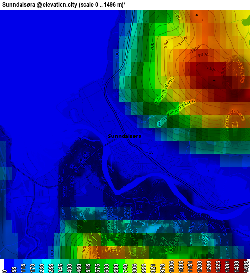
Below is the Elevation map of Sunndalsøra, which displays elevation range with different colors. Scale of the first map is from 0 to 1496 m (0 to 4908 ft) with average elevation of 284.1 meters (=932 ft) [note 1]
These maps also provides idea of topography and contour of this city, they are displayed at different zoom levels. More info about maps, scale and edge coordinates you can find below images.
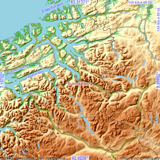
| \ | Map #1 | Map #2 | Topo.Map |
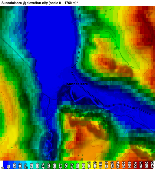
| Scale [m] | 0..1496 m | 0..1760 m | × |
| Scale [ft] | 0..4908 ft | 0..5774 ft | × |
| Average | 284.1 m = 932 ft | 572.2 m = 1877 ft | × |
| Width | 4.49 km = 2.8 mi | 8.97 km = 5.6 mi | 143.6 km = 89.2 mi |
| Height | 4.49 km = 2.8 mi | 8.97 km = 5.6 mi | 143.5 km = 89.2 mi |
| ↑Max Latitude | 62.695356° | 62.715507° | 63.31371° |
| Latitude at center | 62.67519° | 62.67519° | 62.67519° |
| ↓Min Latitude | 62.655011° | 62.634818° | 62.0226° |
| ← Min Longitude | 8.519325° | 8.475379° | 7.15702° |
| Longitude center | 8.56327° | 8.56327° | 8.56327° |
| →Max Longitude | 8.607215° | 8.651161° | 9.96952° |
Nearby cities:
Cities around Sunndalsøra sort by population:
• Oppdal elevation 550 m
58.3 km,  98°
98°
• Rensvik 40 m
60.3 km,  321°
321°
• Åndalsnes 19 m
46.4 km,  255°
255°
• Eide 10 m
62.8 km,  295°
295°
• Hjelset 7 m
55.8 km,  282°
282°
• Tingvoll 40 m
32.1 km,  325°
325°
• Eidsvåg 12 m
27.8 km,  293°
293°
• Rindal 160 m
53.6 km,  37°
37°
• Batnfjordsøra 3 m
51.4 km, 298°
• Bruhagen 20 m
63.1 km,  311°
311°
• Liabøen 75 m
51.3 km,  345°
345°
• Surnadal 124 m
34.2 km,  13°
13°
Multilingual:
 En español:
Sunndalsøra elevación 346 m.
 En France:
Sunndalsøra élévation 346 m.
 Auf Deutsch:
Sunndalsøra höhe über dem Meeresspiegel ist 346 m.

Sources and notes:
- [note 1] Map square and city borders are not equal. Map elevation data is calculated only from area inside that square.
- [src 1] Elevation data from geonames database provided with same terms of usage.
- [src 2] The elevation map of Sunndalsøra is generated using GMTED2010 database with 7.5 arcsec (225m) resolution.
- [src 3] Base (background) map © OpenStreetMap contributors tiles are generated by Geofabrik and OpenTopoMap.
Copyright & License:
This Sunndalsøra Elevation Map is licensed under CC BY-SA. You may reuse any part from this page, if you give a proper credit by linking to this URL:
 More info on terms of use page.