Trondheim elevation
Trondheim (Trøndelag), Norway elevation is 18 meters and Trondheim elevation in feet is 59 ft above sea level [src 1]. Trondheim is a seat of a second-order administrative division (feature code) with elevation that is 83 meters (272 ft) smaller than average city elevation in Norway.
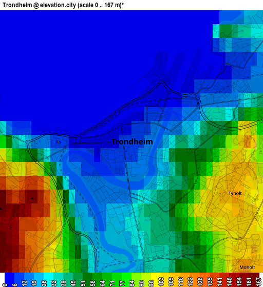
Below is the Elevation map of Trondheim, which displays elevation range with different colors. Scale of the first map is from 0 to 167 m (0 to 548 ft) with average elevation of 38.3 meters (=126 ft) [note 1]
These maps also provides idea of topography and contour of this city, they are displayed at different zoom levels. More info about maps, scale and edge coordinates you can find below images.
| \ | Map #1 | Map #2 | Topo.Map |
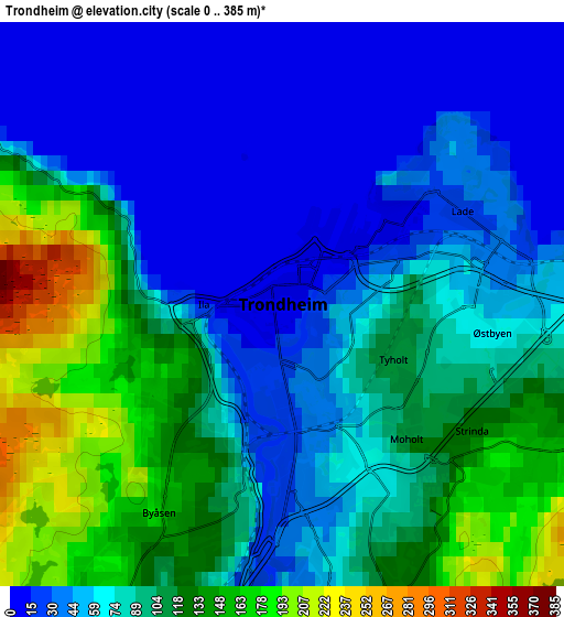
| Scale [m] | 0..167 m | 0..385 m | × |
| Scale [ft] | 0..548 ft | 0..1263 ft | × |
| Average | 38.3 m = 126 ft | 80.3 m = 263 ft | × |
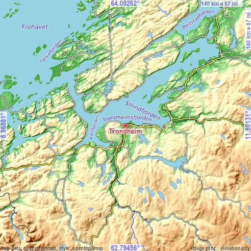
| Width | 4.37 km = 2.7 mi | 8.74 km = 5.4 mi | 139.9 km = 86.9 mi |
| Height | 4.37 km = 2.7 mi | 8.74 km = 5.4 mi | 139.9 km = 86.9 mi |
| ↑Max Latitude | 63.450139° | 63.469775° | 64.05262° |
| Latitude at center | 63.43049° | 63.43049° | 63.43049° |
| ↓Min Latitude | 63.410827° | 63.391151° | 62.79456° |
| ← Min Longitude | 10.351115° | 10.307169° | 8.98881° |
| Longitude center | 10.39506° | 10.39506° | 10.39506° |
| →Max Longitude | 10.439005° | 10.482951° | 11.80131° |
Nearby cities:
Cities around Trondheim sort by population:
• Stjørdalshalsen elevation 15 m
26.7 km,  80°
80°
• Malvik 84 m
14.3 km,  88°
88°
• Melhus 40 m
17.1 km,  199°
199°
• Hommelvik 12 m
20 km,  96°
96°
• Frosta 60 m
24.6 km,  44°
44°
• Skaun 160 m
26.2 km,  220°
220°
• Orkanger 100 m
30.4 km,  243°
243°
• Leksvik 1 m
29.2 km,  22°
22°
• Rissa 33 m
27.5 km,  308°
308°
• Stjørdal 12 m
26.3 km, 80°
• Børsa 1 m
19.9 km,  234°
234°
• Klæbu 140 m
15.4 km,  163°
163°
Multilingual:
 En español:
Trondheim elevación 18 m.
 En France:
Trondheim élévation 18 m.
 Auf Deutsch:
Trondheim höhe über dem Meeresspiegel ist 18 m.

Sources and notes:
- [note 1] Map square and city borders are not equal. Map elevation data is calculated only from area inside that square.
- [src 1] Elevation data from geonames database provided with same terms of usage.
- [src 2] The elevation map of Trondheim is generated using GMTED2010 database with 7.5 arcsec (225m) resolution.
- [src 3] Base (background) map © OpenStreetMap contributors tiles are generated by Geofabrik and OpenTopoMap.
Copyright & License:
This Trondheim Elevation Map is licensed under CC BY-SA. You may reuse any part from this page, if you give a proper credit by linking to this URL:
 More info on terms of use page.