Hengstdal elevation
Hengstdal (Gelderland, Gemeente Nijmegen), Netherlands elevation is 44 meters and Hengstdal elevation in feet is 144 ft above sea level [src 1]. Hengstdal is a section of populated place (feature code) with elevation that is 29 meters (95 ft) bigger than average city elevation in Netherlands.
Below is the Elevation map of Hengstdal, which displays elevation range with different colors. Scale of the first map is from 1 to 102 m (3 to 335 ft) with average elevation of 34.2 meters (=112 ft) [note 1]
These maps also provides idea of topography and contour of this city, they are displayed at different zoom levels. More info about maps, scale and edge coordinates you can find below images.
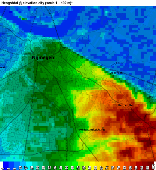
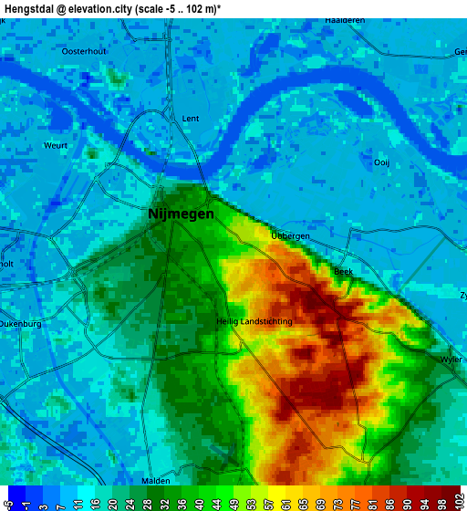
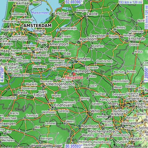
| \ | Map #1 | Map #2 | Topo.Map |
| Scale [m] | 1..102 m | -5..102 m | × |
| Scale [ft] | 3..335 ft | -16..335 ft | × |
| Average | 34.2 m = 112 ft | 23.9 m = 78 ft | × |
| Width | 6.04 km = 3.8 mi | 12.08 km = 7.5 mi | 193.3 km = 120.1 mi |
| Height | 6.04 km = 3.8 mi | 12.08 km = 7.5 mi | 193.2 km = 120 mi |
| ↑Max Latitude | 51.860478° | 51.887609° | 52.69396° |
| Latitude at center | 51.83333° | 51.83333° | 51.83333° |
| ↓Min Latitude | 51.806166° | 51.778985° | 50.95593° |
| ← Min Longitude | 5.839385° | 5.795439° | 4.47708° |
| Longitude center | 5.88333° | 5.88333° | 5.88333° |
| →Max Longitude | 5.927275° | 5.971221° | 7.28958° |
Nearby cities:
Cities around Hengstdal sort by population:
• Nijmegen elevation 25 m
2.3 km,  295°
295°
• Lindenholt 8 m
6.2 km,  269°
269°
• Bemmel 13 m
6.6 km,  9°
9°
• Hatert 13 m
4.7 km,  230°
230°
• Lent 11 m
3.4 km,  340°
340°
• Hunnerberg 41 m
1 km, 342°
• Brakkenstein 25 m
2.6 km,  208°
208°
• Hees 10 m
3.9 km,  283°
283°
• Oosterhout 11 m
6.5 km,  323°
323°
• Ooij 12 m
4.5 km,  58°
58°
• Berg en Dal 95 m
2.6 km,  119°
119°
• Haalderen 10 m
6.8 km,  27°
27°
Multilingual:
 En español:
Hengstdal elevación 44 m.
 En France:
Hengstdal élévation 44 m.
 Auf Deutsch:
Hengstdal höhe über dem Meeresspiegel ist 44 m.

Sources and notes:
- [note 1] Map square and city borders are not equal. Map elevation data is calculated only from area inside that square.
- [src 1] Elevation data from geonames database provided with same terms of usage.
- [src 2] The elevation map of Hengstdal is generated using elevation data from NASA's 3 arcsec (90m) resolution SRTM data.
- [src 3] Base (background) map © OpenStreetMap contributors tiles are generated by Geofabrik and OpenTopoMap.
Copyright & License:
This Hengstdal Elevation Map is licensed under CC BY-SA. You may reuse any part from this page, if you give a proper credit by linking to this URL:
 More info on terms of use page.