Ootmarsum elevation
Ootmarsum (Overijssel, Gemeente Dinkelland), Netherlands elevation is 36 meters and Ootmarsum elevation in feet is 118 ft above sea level [src 1]. Ootmarsum is a populated place (feature code) with elevation that is 21 meters (69 ft) bigger than average city elevation in Netherlands.
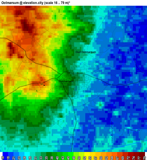
Below is the Elevation map of Ootmarsum, which displays elevation range with different colors. Scale of the first map is from 16 to 79 m (52 to 259 ft) with average elevation of 35.2 meters (=115 ft) [note 1]
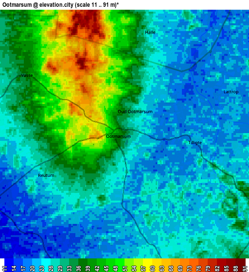
These maps also provides idea of topography and contour of this city, they are displayed at different zoom levels. More info about maps, scale and edge coordinates you can find below images.
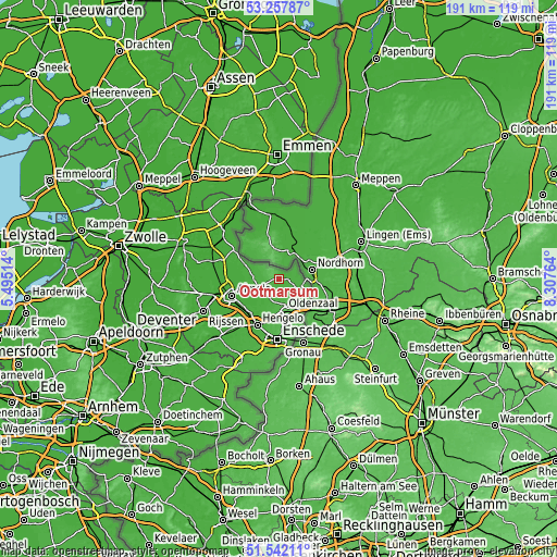
| \ | Map #1 | Map #2 | Topo.Map |
| Scale [m] | 16..79 m | 11..91 m | × |
| Scale [ft] | 52..259 ft | 36..299 ft | × |
| Average | 35.2 m = 115 ft | 30.9 m = 101 ft | × |
| Width | 5.96 km = 3.7 mi | 11.92 km = 7.4 mi | 190.8 km = 118.6 mi |
| Height | 5.96 km = 3.7 mi | 11.92 km = 7.4 mi | 190.8 km = 118.6 mi |
| ↑Max Latitude | 52.43513° | 52.461913° | 53.25787° |
| Latitude at center | 52.40833° | 52.40833° | 52.40833° |
| ↓Min Latitude | 52.381514° | 52.354681° | 51.54211° |
| ← Min Longitude | 6.857445° | 6.813499° | 5.49514° |
| Longitude center | 6.90139° | 6.90139° | 6.90139° |
| →Max Longitude | 6.945335° | 6.989281° | 8.30764° |
Nearby cities:
Cities around Ootmarsum sort by population:
• Hengelo elevation 18 m
17.5 km,  204°
204°
• Almelo 15 m
17.2 km,  250°
250°
• Oldenzaal 48 m
10.7 km,  169°
169°
• Losser 37 m
17.8 km,  156°
156°
• Borne 18 m
15.8 km,  221°
221°
• Tubbergen 25 m
7.9 km,  269°
269°
• Vriezenveen 10 m
18.9 km, 270°
• Zuid-Berghuizen 45 m
12.1 km, 169°
• Nijrees 12 m
18.1 km,  243°
243°
• Woolde 18 m
18 km,  212°
212°
• Klein Driene 20 m
16.5 km, 200°
• Rossum 28 m
6.5 km, 167°
Multilingual:
 En español:
Ootmarsum elevación 36 m.
 En France:
Ootmarsum élévation 36 m.
 Auf Deutsch:
Ootmarsum höhe über dem Meeresspiegel ist 36 m.

Sources and notes:
- [note 1] Map square and city borders are not equal. Map elevation data is calculated only from area inside that square.
- [src 1] Elevation data from geonames database provided with same terms of usage.
- [src 2] The elevation map of Ootmarsum is generated using elevation data from NASA's 3 arcsec (90m) resolution SRTM data.
- [src 3] Base (background) map © OpenStreetMap contributors tiles are generated by Geofabrik and OpenTopoMap.
Copyright & License:
This Ootmarsum Elevation Map is licensed under CC BY-SA. You may reuse any part from this page, if you give a proper credit by linking to this URL:
 More info on terms of use page.