Roermond elevation
Roermond (Limburg, Gemeente Roermond), Netherlands elevation is 31 meters and Roermond elevation in feet is 102 ft above sea level [src 1]. Roermond is a populated place (feature code) with elevation that is 16 meters (52 ft) bigger than average city elevation in Netherlands.
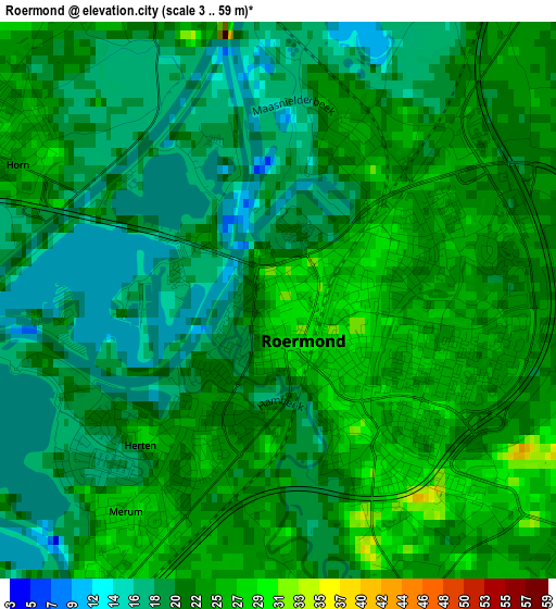
Below is the Elevation map of Roermond, which displays elevation range with different colors. Scale of the first map is from 3 to 59 m (10 to 194 ft) with average elevation of 21.6 meters (=71 ft) [note 1]
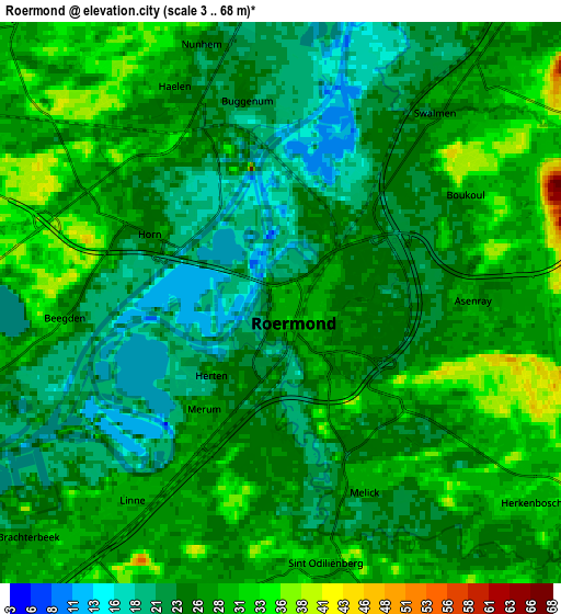
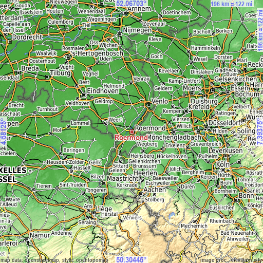
These maps also provides idea of topography and contour of this city, they are displayed at different zoom levels. More info about maps, scale and edge coordinates you can find below images.
| \ | Map #1 | Map #2 | Topo.Map |
| Scale [m] | 3..59 m | 3..68 m | × |
| Scale [ft] | 10..194 ft | 10..223 ft | × |
| Average | 21.6 m = 71 ft | 25.4 m = 83 ft | × |
| Width | 6.12 km = 3.8 mi | 12.25 km = 7.6 mi | 196 km = 121.8 mi |
| Height | 6.12 km = 3.8 mi | 12.25 km = 7.6 mi | 196 km = 121.8 mi |
| ↑Max Latitude | 51.221702° | 51.249217° | 52.06703° |
| Latitude at center | 51.19417° | 51.19417° | 51.19417° |
| ↓Min Latitude | 51.166622° | 51.139058° | 50.30445° |
| ← Min Longitude | 5.943555° | 5.899609° | 4.58125° |
| Longitude center | 5.9875° | 5.9875° | 5.9875° |
| →Max Longitude | 6.031445° | 6.075391° | 7.39375° |
Nearby cities:
Cities around Roermond sort by population:
• Haelen elevation 26 m
5.1 km,  335°
335°
• Heel 29 m
6.7 km,  255°
255°
• Herkenbosch 32 m
7 km,  130°
130°
• Melick 28 m
4.4 km,  152°
152°
• Linne 29 m
5.5 km,  217°
217°
• Herten 23 m
2.3 km,  229°
229°
• Montfort 30 m
8.1 km,  199°
199°
• Sint Odiliënberg 31 m
5.7 km,  171°
171°
• Merum 27 m
3 km, 219°
• Beegden 32 m
4.8 km, 263°
• Brachterbeek 28 m
7.8 km, 227°
• Leeuwen 25 m
2 km,  23°
23°
Multilingual:
 En español:
Roermond elevación 31 m.
 En France:
Ruremonde élévation 31 m.


Sources and notes:
- [note 1] Map square and city borders are not equal. Map elevation data is calculated only from area inside that square.
- [src 1] Elevation data from geonames database provided with same terms of usage.
- [src 2] The elevation map of Roermond is generated using elevation data from NASA's 3 arcsec (90m) resolution SRTM data.
- [src 3] Base (background) map © OpenStreetMap contributors tiles are generated by Geofabrik and OpenTopoMap.
Copyright & License:
This Roermond Elevation Map is licensed under CC BY-SA. You may reuse any part from this page, if you give a proper credit by linking to this URL:
 More info on terms of use page.