El Jicaral elevation
El Jicaral (León), Nicaragua elevation is 122 meters and El Jicaral elevation in feet is 400 ft above sea level [src 1]. El Jicaral is a seat of a second-order administrative division (feature code) with elevation that is 219 meters (719 ft) smaller than average city elevation in Nicaragua.
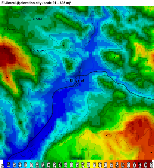
Below is the Elevation map of El Jicaral, which displays elevation range with different colors. Scale of the first map is from 91 to 693 m (299 to 2274 ft) with average elevation of 276.5 meters (=907 ft) [note 1]
These maps also provides idea of topography and contour of this city, they are displayed at different zoom levels. More info about maps, scale and edge coordinates you can find below images.
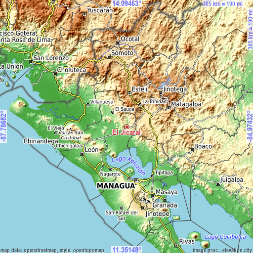
| \ | Map #1 | Topo.Map |
| Scale [m] | 91..693 m | × |
| Scale [ft] | 299..2274 ft | × |
| Average | 276.5 m = 907 ft | × |
| Width | 9.53 km = 5.9 mi | 305 km = 189.5 mi |
| Height | 9.53 km = 5.9 mi | 305 km = 189.5 mi |
| ↑Max Latitude | 12.769622° | 14.09463° |
| Latitude at center | 12.72676° | 12.72676° |
| ↓Min Latitude | 12.683891° | 11.35148° |
| ← Min Longitude | -86.424515° | -87.78682° |
| Longitude center | -86.38057° | -86.38057° |
| →Max Longitude | -86.336625° | -84.97432° |
Nearby cities:
Cities around El Jicaral sort by population:
• Estelí elevation 840 m
40.7 km,  4°
4°
• Ciudad Darío 456 m
27.8 km,  88°
88°
• El Sauce 173 m
24.7 km,  316°
316°
• Larreynaga 97 m
21.5 km,  255°
255°
• Santa Rosa del Peñón 176 m
8.4 km,  7°
7°
• Valle San Francisco 110 m
25.6 km,  155°
155°
• Malpaisillo 119 m
35.6 km,  245°
245°
• Sébaco 475 m
33.9 km,  65°
65°
• La Trinidad 611 m
31.2 km,  30°
30°
• San Isidro 484 m
30.2 km,  41°
41°
• San Francisco Libre 50 m
26.2 km, 160°
• San Nicolás 990 m
23.1 km, 8°
Multilingual:
 En español:
El Jicaral elevación 122 m.
 En France:
El Jicaral élévation 122 m.
 Auf Deutsch:
El Jicaral höhe über dem Meeresspiegel ist 122 m.

Sources and notes:
- [note 1] Map square and city borders are not equal. Map elevation data is calculated only from area inside that square.
- [src 1] Elevation data from geonames database provided with same terms of usage.
- [src 2] The elevation map of El Jicaral is generated using elevation data from NASA's 3 arcsec (90m) resolution SRTM data.
- [src 3] Base (background) map © OpenStreetMap contributors tiles are generated by Geofabrik and OpenTopoMap.
Copyright & License:
This El Jicaral Elevation Map is licensed under CC BY-SA. You may reuse any part from this page, if you give a proper credit by linking to this URL:
 More info on terms of use page.